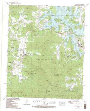
Hiawassee Topo Map Georgia
To zoom in, hover over the map of Hiawassee
USGS Topo Quad 34083h7 - 1:24,000 scale
| Topo Map Name: | Hiawassee |
| USGS Topo Quad ID: | 34083h7 |
| Print Size: | ca. 21 1/4" wide x 27" high |
| Southeast Coordinates: | 34.875° N latitude / 83.75° W longitude |
| Map Center Coordinates: | 34.9375° N latitude / 83.8125° W longitude |
| U.S. States: | GA, NC |
| Filename: | o34083h7.jpg |
| Download Map JPG Image: | Hiawassee topo map 1:24,000 scale |
| Map Type: | Topographic |
| Topo Series: | 7.5´ |
| Map Scale: | 1:24,000 |
| Source of Map Images: | United States Geological Survey (USGS) |
| Alternate Map Versions: |
Hiawassee GA 1935 Download PDF Buy paper map Hiawassee GA 1941 Download PDF Buy paper map Hiawassee GA 1941, updated 1965 Download PDF Buy paper map Hiawassee GA 1942 Download PDF Buy paper map Hiawassee GA 1942 Download PDF Buy paper map Hiawassee GA 1966, updated 1968 Download PDF Buy paper map Hiawassee GA 1988, updated 1988 Download PDF Buy paper map Hiawassee GA 1988, updated 1988 Download PDF Buy paper map Hiawassee GA 2011 Download PDF Buy paper map Hiawassee GA 2014 Download PDF Buy paper map |
| FStopo: | US Forest Service topo Hiawassee is available: Download FStopo PDF Download FStopo TIF |
1:24,000 Topo Quads surrounding Hiawassee
> Back to 34083e1 at 1:100,000 scale
> Back to 34082a1 at 1:250,000 scale
> Back to U.S. Topo Maps home
Hiawassee topo map: Gazetteer
Hiawassee: Basins
Big Bald Cove elevation 867m 2844′Harris Cove elevation 663m 2175′
Kirby Cove elevation 693m 2273′
Hiawassee: Bays
Bayless Cove elevation 726m 2381′Burrell Cove elevation 588m 1929′
Dayton Cove elevation 588m 1929′
McClure Cove elevation 588m 1929′
McIntosh Cove elevation 588m 1929′
Rocky Cove elevation 757m 2483′
Swanson Cove elevation 584m 1916′
Walnut Cove elevation 620m 2034′
Woods Creek elevation 589m 1932′
Hiawassee: Cliffs
Sheep Nose elevation 636m 2086′Hiawassee: Falls
Haynes Falls elevation 670m 2198′Hiawassee: Gaps
Brasstown Gap elevation 668m 2191′Carrol Gap elevation 847m 2778′
Cove Gap elevation 1041m 3415′
Crow Gap elevation 774m 2539′
Flat Gap elevation 886m 2906′
Jones Gap elevation 812m 2664′
Low Gap elevation 1093m 3585′
Mining Gap elevation 702m 2303′
Nelson Gap elevation 796m 2611′
Norton Gap elevation 931m 3054′
Salt Gap elevation 731m 2398′
Sims Gap elevation 906m 2972′
Woodring Gap elevation 749m 2457′
Hiawassee: Guts
Woods Creek elevation 588m 1929′Hiawassee: Islands
Brown Island elevation 588m 1929′Hiawassee: Parks
Chatuge State Park elevation 607m 1991′Lake Chatuge Recreation Area elevation 593m 1945′
Plott Cove Reserve Nature Area elevation 955m 3133′
Towns County Park elevation 624m 2047′
Young Harris College Historic District elevation 583m 1912′
Hiawassee: Populated Places
Campagne (historical) elevation 614m 2014′Cedar Cliff elevation 605m 1984′
Friendship elevation 607m 1991′
Hiawassee elevation 601m 1971′
Hunt (historical) elevation 588m 1929′
Jacksonville elevation 593m 1945′
Sunnyside elevation 614m 2014′
Townsend Mill elevation 574m 1883′
Trackrock (historical) elevation 597m 1958′
Young Harris elevation 586m 1922′
Hiawassee: Reservoirs
Sanders Pond elevation 575m 1886′Hiawassee: Ridges
Brushy Ridge elevation 949m 3113′Buck Ridge elevation 1072m 3517′
Buzzard Ridge elevation 1151m 3776′
Dave Ridge elevation 813m 2667′
Double Knob Ridge elevation 912m 2992′
Long Ridge elevation 773m 2536′
Red Banks elevation 607m 1991′
Tarkiln Ridge elevation 954m 3129′
Hiawassee: Streams
Bare Branch elevation 589m 1932′Beech Branch elevation 560m 1837′
Bell Creek elevation 588m 1929′
Berry Branch elevation 634m 2080′
Bitter Creek elevation 575m 1886′
Burch Branch elevation 588m 1929′
Byers Creek elevation 555m 1820′
Caldwell Branch elevation 582m 1909′
Corn Creek elevation 553m 1814′
Emerson Branch elevation 539m 1768′
Green Branch elevation 632m 2073′
Hog Creek elevation 607m 1991′
Hooper Branch elevation 606m 1988′
Johnson Branch elevation 560m 1837′
Jones Branch elevation 618m 2027′
Keys Branch elevation 547m 1794′
Kirby Branch elevation 613m 2011′
Left Prong Brasstown Creek elevation 633m 2076′
Long Bullet Branch elevation 589m 1932′
Long Bullet Creek elevation 588m 1929′
Mud Branch elevation 563m 1847′
Mud Branch elevation 565m 1853′
Norton Branch elevation 592m 1942′
Puncheon Camp Branch elevation 690m 2263′
Reed Branch elevation 588m 1929′
Right Fork Arkaqua Creek elevation 662m 2171′
Right Fork Fodder Creek elevation 662m 2171′
Rocky Branch elevation 627m 2057′
Sneaking Creek elevation 588m 1929′
Sneaking Creek elevation 588m 1929′
Stephens Branch elevation 598m 1961′
Sutton Branch elevation 590m 1935′
Wilson Cove Creek elevation 595m 1952′
Woodring Branch elevation 594m 1948′
Woods Creek elevation 588m 1929′
Yewell Branch elevation 565m 1853′
Hiawassee: Summits
Bayless Knob elevation 903m 2962′Cedar Knob elevation 985m 3231′
Chimney Top elevation 1286m 4219′
Davy Mountain elevation 890m 2919′
Double Knob elevation 1224m 4015′
Granny Knob elevation 870m 2854′
Harris Mountain elevation 993m 3257′
Ivy Mountain elevation 783m 2568′
Jones Mountain elevation 971m 3185′
Little Bald Mountain elevation 1345m 4412′
Old Rocky Knob elevation 1119m 3671′
Ramey Mountain elevation 965m 3166′
Rattlesnake Knob elevation 845m 2772′
Rocky Knob elevation 1014m 3326′
Sharp Hill elevation 709m 2326′
Shewbird Mountain elevation 872m 2860′
Swanson Mountain elevation 707m 2319′
Wike Knob elevation 776m 2545′
Hiawassee: Trails
Arkaquah Trail elevation 1108m 3635′Hiawassee: Valleys
Chestnut Cove elevation 988m 3241′Cold Hollow elevation 672m 2204′
Darr Cove elevation 623m 2043′
Dean Cove elevation 570m 1870′
Felix Hollow elevation 593m 1945′
Grassy Branch Cove elevation 770m 2526′
Little Bald Cove elevation 701m 2299′
Patterson Cove elevation 590m 1935′
Peabottom Cove elevation 692m 2270′
Plott Cove elevation 632m 2073′
Waterfall Cove elevation 643m 2109′
Wilson Cove elevation 637m 2089′
Hiawassee digital topo map on disk
Buy this Hiawassee topo map showing relief, roads, GPS coordinates and other geographical features, as a high-resolution digital map file on DVD:
South Carolina, Western North Carolina & Northeastern Georgia
Buy digital topo maps: South Carolina, Western North Carolina & Northeastern Georgia


