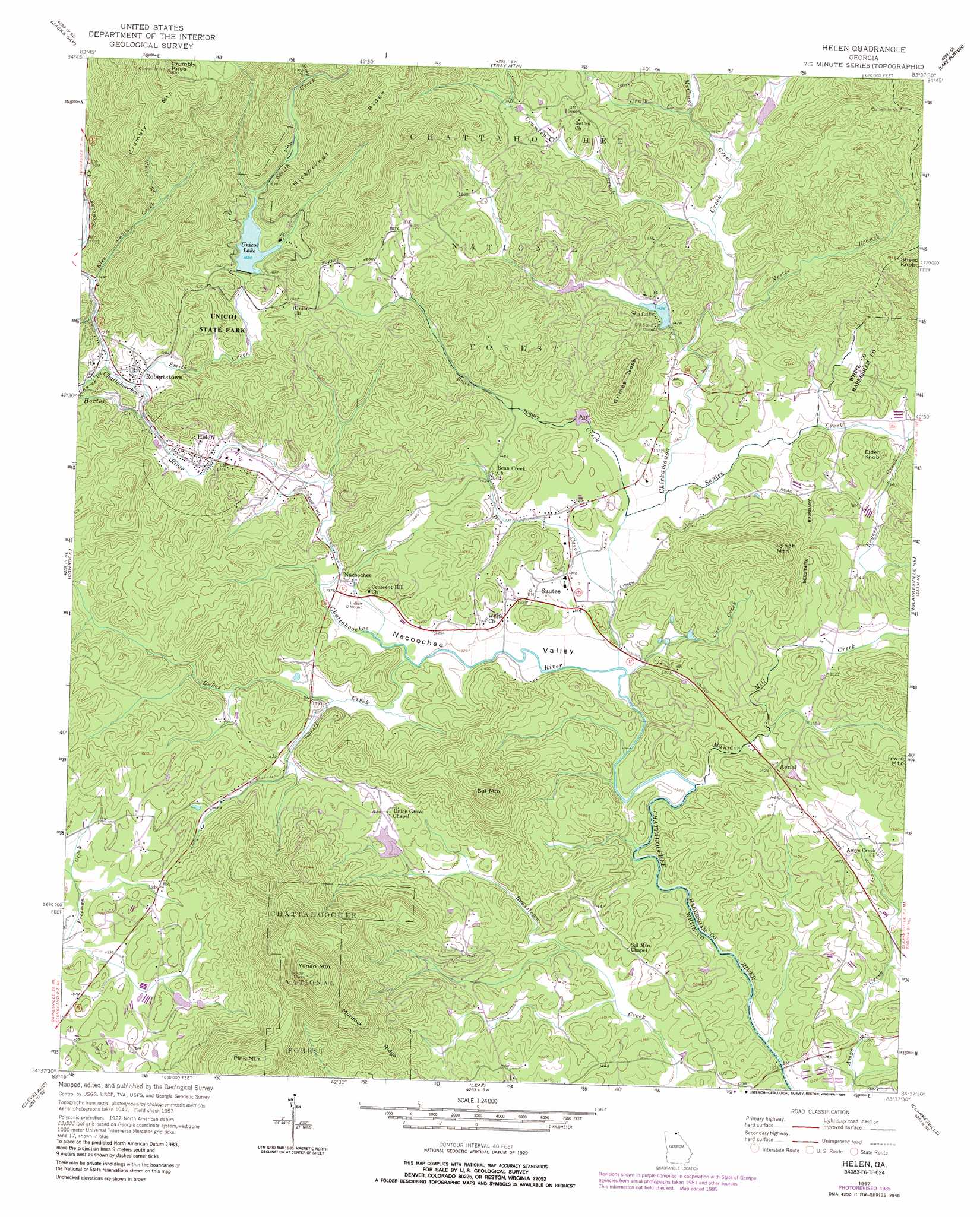
Helen Topo Map Georgia
To zoom in, hover over the map of Helen
USGS Topo Quad 34083f6 - 1:24,000 scale
| Topo Map Name: | Helen |
| USGS Topo Quad ID: | 34083f6 |
| Print Size: | ca. 21 1/4" wide x 27" high |
| Southeast Coordinates: | 34.625° N latitude / 83.625° W longitude |
| Map Center Coordinates: | 34.6875° N latitude / 83.6875° W longitude |
| U.S. State: | GA |
| Filename: | o34083f6.jpg |
| Download Map JPG Image: | Helen topo map 1:24,000 scale |
| Map Type: | Topographic |
| Topo Series: | 7.5´ |
| Map Scale: | 1:24,000 |
| Source of Map Images: | United States Geological Survey (USGS) |
| Alternate Map Versions: |
Helen GA 1957, updated 1958 Download PDF Buy paper map Helen GA 1957, updated 1968 Download PDF Buy paper map Helen GA 1957, updated 1983 Download PDF Buy paper map Helen GA 1957, updated 1986 Download PDF Buy paper map Helen GA 2011 Download PDF Buy paper map Helen GA 2014 Download PDF Buy paper map |
| FStopo: | US Forest Service topo Helen is available: Download FStopo PDF Download FStopo TIF |
1:24,000 Topo Quads surrounding Helen
Blairsville |
Hiawassee |
Macedonia |
Hightower Bald |
Dillard |
Coosa Bald |
Jacks Gap |
Tray Mountain |
Lake Burton |
Tiger |
Neels Gap |
Cowrock |
Helen |
Clarkesville Ne |
Tallulah Falls |
Dahlonega |
Cleveland |
Leaf |
Clarkesville |
Ayersville |
Murrayville |
Clermont |
Lula |
Baldwin |
Russell Lake |
> Back to 34083e1 at 1:100,000 scale
> Back to 34082a1 at 1:250,000 scale
> Back to U.S. Topo Maps home
Helen topo map: Gazetteer
Helen: Cliffs
Grimes Nose elevation 563m 1847′Helen: Dams
Chambers Lake Dam elevation 473m 1551′Mays Lake Dam elevation 503m 1650′
Royal Lake Dam elevation 433m 1420′
Sautee Creek Watershed Number 12 Dam elevation 452m 1482′
Sautee Creek Watershed Number 13 Dam elevation 424m 1391′
Sautee Watershed Number 10 Dam elevation 514m 1686′
Sky Lake Dam elevation 432m 1417′
Unicoi State Park Lake Dam elevation 492m 1614′
Helen: Mines
Childs Mine elevation 473m 1551′Lot Ten Mine elevation 437m 1433′
White County Mine elevation 465m 1525′
Helen: Parks
Sautee Valley Historic District elevation 411m 1348′Unicoi State Park elevation 538m 1765′
Helen: Populated Places
Aerial elevation 434m 1423′Helen elevation 441m 1446′
Lynch (historical) elevation 427m 1400′
Mauldins (historical) elevation 423m 1387′
Nacoochee elevation 416m 1364′
Naguchee (historical) elevation 413m 1354′
Robertstown elevation 442m 1450′
Sautee elevation 422m 1384′
Helen: Post Offices
Helen Post Office elevation 433m 1420′Helen: Reservoirs
Chambers Lake elevation 473m 1551′Mays Lake elevation 503m 1650′
Royal Lake elevation 433m 1420′
Sautee Creek Watershed Number 12 Lake elevation 452m 1482′
Sautee Creek Watershed Number 13 Lake elevation 424m 1391′
Sautee Watershed Number 10 Lake elevation 514m 1686′
Sky Lake elevation 432m 1417′
Unicoi Lake elevation 494m 1620′
Unicoi State Park Lake elevation 494m 1620′
Helen: Ridges
Murdock Ridge elevation 608m 1994′Helen: Streams
Bean Creek elevation 410m 1345′Ben Creek elevation 402m 1318′
Car Creek elevation 396m 1299′
Chickamauga Branch elevation 449m 1473′
Chickamauga Creek elevation 396m 1299′
Church Branch elevation 443m 1453′
Craig Creek elevation 451m 1479′
Crumley Creek elevation 430m 1410′
Dukes Creek elevation 406m 1332′
Horton Creek elevation 445m 1459′
Mauldin Mill Creek elevation 398m 1305′
McClure Creek elevation 438m 1437′
Nester Branch elevation 424m 1391′
Rice Cabin Creek elevation 459m 1505′
Rogers Creek elevation 423m 1387′
Sautee Creek elevation 409m 1341′
Smith Creek elevation 443m 1453′
Spoilcane Creek elevation 458m 1502′
Steep Creek elevation 533m 1748′
White Branch elevation 509m 1669′
Helen: Summits
Crumbly Knob elevation 906m 2972′Crumbly Mountain elevation 831m 2726′
Elder Knob elevation 478m 1568′
Lynch Mountain elevation 636m 2086′
Nacoochee Indian Mound elevation 412m 1351′
Pink Mountain elevation 796m 2611′
Sal Mountain elevation 683m 2240′
Sheep Knob elevation 584m 1916′
Yonah Mountain elevation 958m 3143′
Helen: Valleys
Nacoochee Valley elevation 396m 1299′Scorpion Hollow elevation 448m 1469′
Helen digital topo map on disk
Buy this Helen topo map showing relief, roads, GPS coordinates and other geographical features, as a high-resolution digital map file on DVD:
South Carolina, Western North Carolina & Northeastern Georgia
Buy digital topo maps: South Carolina, Western North Carolina & Northeastern Georgia