Grayson Topo Map Alabama
To zoom in, hover over the map of Grayson
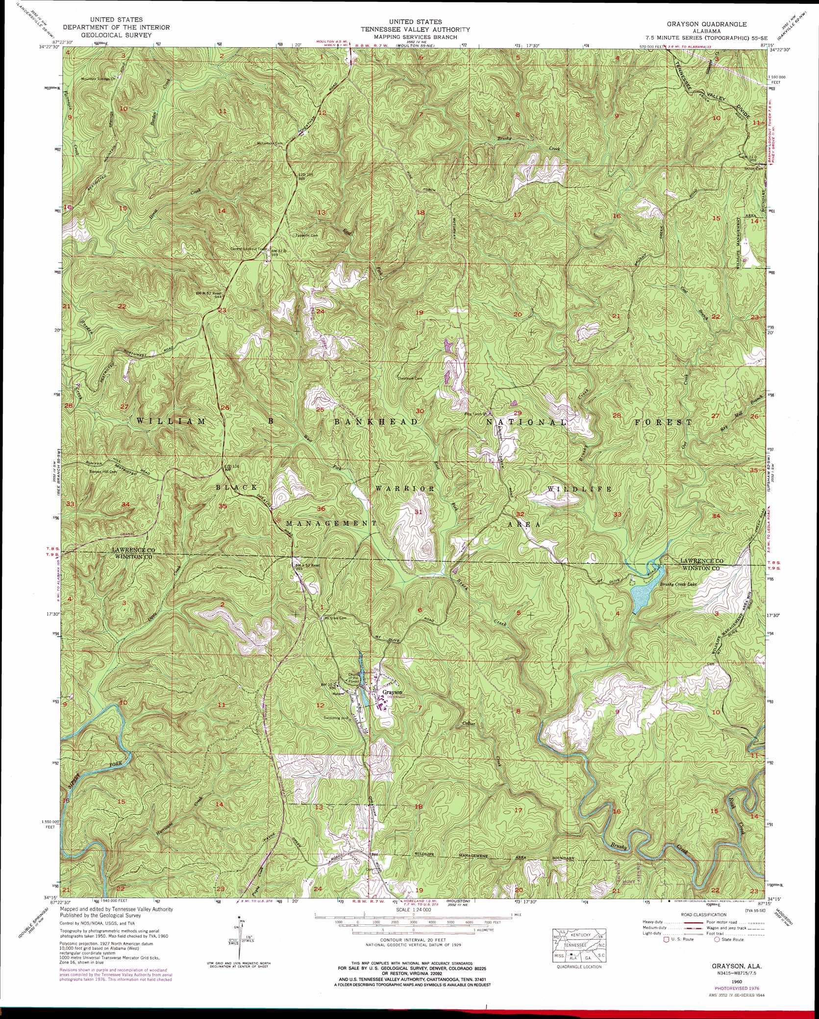
USGS Topo Quad 34087c3 - 1:24,000 scale
| Topo Map Name: | Grayson |
| USGS Topo Quad ID: | 34087c3 |
| Print Size: | ca. 21 1/4" wide x 27" high |
| Southeast Coordinates: | 34.25° N latitude / 87.25° W longitude |
| Map Center Coordinates: | 34.3125° N latitude / 87.3125° W longitude |
| U.S. State: | AL |
| Filename: | o34087c3.jpg |
| Download Map JPG Image: | Grayson topo map 1:24,000 scale |
| Map Type: | Topographic |
| Topo Series: | 7.5´ |
| Map Scale: | 1:24,000 |
| Source of Map Images: | United States Geological Survey (USGS) |
| Alternate Map Versions: |
Grayson AL 1960, updated 1961 Download PDF Buy paper map Grayson AL 1960, updated 1974 Download PDF Buy paper map Grayson AL 1960, updated 1977 Download PDF Buy paper map Grayson AL 2000, updated 2003 Download PDF Buy paper map Grayson AL 2011 Download PDF Buy paper map Grayson AL 2014 Download PDF Buy paper map |
| FStopo: | US Forest Service topo Grayson is available: Download FStopo PDF Download FStopo TIF |
1:24,000 Topo Quads surrounding Grayson
Old Bethel |
Hatton |
Masterson |
Caddo |
Trinity |
Newburg |
Landersville |
Moulton |
Oakville |
Danville |
Kinlock Spring |
Bee Branch |
Grayson |
Upshaw |
Massey |
Haleyville East |
Double Springs |
Houston |
Addison |
Jones Chapel |
Lynn |
Poplar Springs |
Black Pond |
Arley |
Crane Hill |
> Back to 34087a1 at 1:100,000 scale
> Back to 34086a1 at 1:250,000 scale
> Back to U.S. Topo Maps home
Grayson topo map: Gazetteer
Grayson: Dams
Brushy Creek Lake Dam elevation 190m 623′Grayson Lake Dam elevation 245m 803′
Grayson: Parks
Black Warrior Wildlife Management Area elevation 276m 905′Brushy Creek Recreational Area elevation 192m 629′
Grayson: Populated Places
Ellaville elevation 264m 866′Grayson elevation 258m 846′
Hepsidam elevation 296m 971′
Grayson: Post Offices
Collier Creek Post Office (historical) elevation 272m 892′Ellaville Post Office (historical) elevation 264m 866′
Grayson Post Office (historical) elevation 259m 849′
Grayson: Reservoirs
Brushy Creek Lake elevation 192m 629′Grayson Lake elevation 245m 803′
Grayson: Ridges
McDougal Ridge elevation 294m 964′Grayson: Streams
Beech Creek elevation 183m 600′Coal Branch elevation 207m 679′
Collier Creek elevation 176m 577′
Davis Creek elevation 162m 531′
East Fork Beech Creek elevation 190m 623′
Horse Creek elevation 181m 593′
Hurricane Creek elevation 160m 524′
Key Mill Branch elevation 198m 649′
Lloyds Creek elevation 165m 541′
Montgomery Creek elevation 187m 613′
Owl Creek elevation 191m 626′
Rush Creek elevation 169m 554′
West Fork Beech Creek elevation 190m 623′
Grayson: Valleys
Collier Creek Canyon elevation 177m 580′Lloyds Canyon elevation 165m 541′
Grayson digital topo map on disk
Buy this Grayson topo map showing relief, roads, GPS coordinates and other geographical features, as a high-resolution digital map file on DVD: