Malone Topo Map Mississippi
To zoom in, hover over the map of Malone
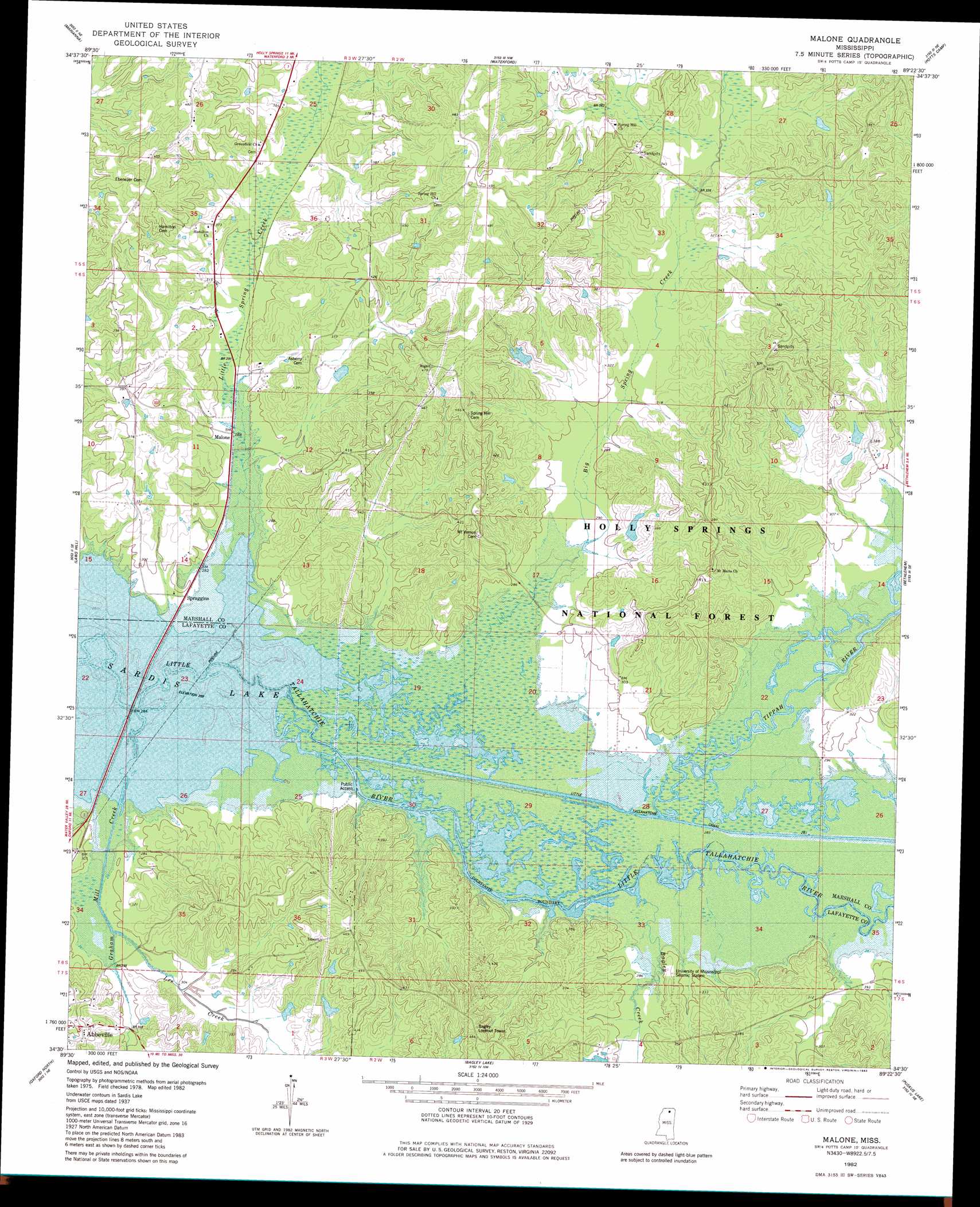
USGS Topo Quad 34089e4 - 1:24,000 scale
| Topo Map Name: | Malone |
| USGS Topo Quad ID: | 34089e4 |
| Print Size: | ca. 21 1/4" wide x 27" high |
| Southeast Coordinates: | 34.5° N latitude / 89.375° W longitude |
| Map Center Coordinates: | 34.5625° N latitude / 89.4375° W longitude |
| U.S. State: | MS |
| Filename: | o34089e4.jpg |
| Download Map JPG Image: | Malone topo map 1:24,000 scale |
| Map Type: | Topographic |
| Topo Series: | 7.5´ |
| Map Scale: | 1:24,000 |
| Source of Map Images: | United States Geological Survey (USGS) |
| Alternate Map Versions: |
Malone MS 1982, updated 1983 Download PDF Buy paper map Malone MS 2000, updated 2003 Download PDF Buy paper map Malone MS 2012 Download PDF Buy paper map Malone MS 2015 Download PDF Buy paper map |
| FStopo: | US Forest Service topo Malone is available: Download FStopo PDF Download FStopo TIF |
1:24,000 Topo Quads surrounding Malone
Byhalia |
Red Banks |
Holly Springs |
Holly Springs Se |
Ashland |
Wyatte |
Marianna |
Waterford |
Potts Camp |
Chilli Creek |
Tyro |
Laws Hill |
Malone |
Bethlehem |
Hickory Flat |
Coles Point |
Oxford North |
Bagley Lake |
Puskus Lake |
Etta |
Splinter |
Oxford South |
Yocona |
Denmark |
Thaxton |
> Back to 34089e1 at 1:100,000 scale
> Back to 34088a1 at 1:250,000 scale
> Back to U.S. Topo Maps home
Malone topo map: Gazetteer
Malone: Crossings
Dukes Ferry (historical) elevation 81m 265′Malone: Dams
Gaylon Lake Dam elevation 100m 328′Morgan Lake Dam elevation 129m 423′
Morgan Lake Dam elevation 105m 344′
Watkins Lake Dam elevation 121m 396′
Malone: Parks
Graham Wildlife Management Area elevation 81m 265′Tallahatchie Experimental Forest elevation 127m 416′
Malone: Populated Places
Malone elevation 87m 285′Spraggins elevation 85m 278′
Malone: Streams
Bagley Creek elevation 81m 265′Big Spring Creek elevation 85m 278′
Graham Mill Creek elevation 81m 265′
Lee Creek elevation 84m 275′
Little Spring Creek elevation 81m 265′
Morgan Branch elevation 81m 265′
Tippah River elevation 81m 265′
Malone digital topo map on disk
Buy this Malone topo map showing relief, roads, GPS coordinates and other geographical features, as a high-resolution digital map file on DVD: