Chilli Creek Topo Map Mississippi
To zoom in, hover over the map of Chilli Creek
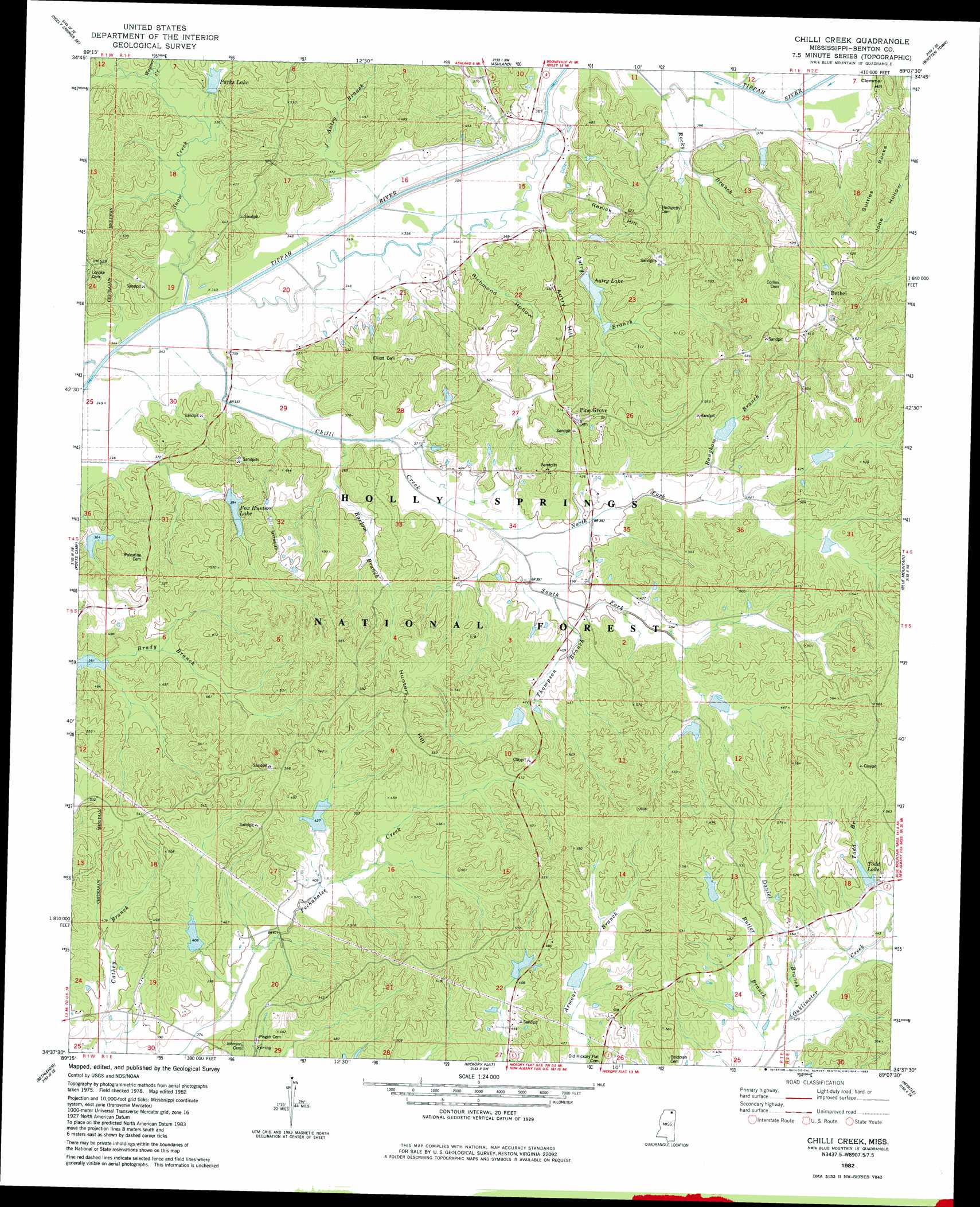
USGS Topo Quad 34089f2 - 1:24,000 scale
| Topo Map Name: | Chilli Creek |
| USGS Topo Quad ID: | 34089f2 |
| Print Size: | ca. 21 1/4" wide x 27" high |
| Southeast Coordinates: | 34.625° N latitude / 89.125° W longitude |
| Map Center Coordinates: | 34.6875° N latitude / 89.1875° W longitude |
| U.S. State: | MS |
| Filename: | o34089f2.jpg |
| Download Map JPG Image: | Chilli Creek topo map 1:24,000 scale |
| Map Type: | Topographic |
| Topo Series: | 7.5´ |
| Map Scale: | 1:24,000 |
| Source of Map Images: | United States Geological Survey (USGS) |
| Alternate Map Versions: |
Chilli Creek MS 1982, updated 1983 Download PDF Buy paper map Chilli Creek MS 2000, updated 2003 Download PDF Buy paper map Chilli Creek MS 2012 Download PDF Buy paper map Chilli Creek MS 2015 Download PDF Buy paper map |
| FStopo: | US Forest Service topo Chilli Creek is available: Download FStopo PDF Download FStopo TIF |
1:24,000 Topo Quads surrounding Chilli Creek
Slayden |
Lamar |
Canaan |
Camp Hill |
Walnut |
Holly Springs |
Holly Springs Se |
Ashland |
Whitten Town |
Falkner |
Waterford |
Potts Camp |
Chilli Creek |
Blue Mountain |
Ripley |
Malone |
Bethlehem |
Hickory Flat |
Myrtle |
Keownville |
Bagley Lake |
Puskus Lake |
Etta |
New Albany West |
New Albany East |
> Back to 34089e1 at 1:100,000 scale
> Back to 34088a1 at 1:250,000 scale
> Back to U.S. Topo Maps home
Chilli Creek topo map: Gazetteer
Chilli Creek: Dams
Cannon Lake Dam elevation 116m 380′LT 7-8 Dam elevation 143m 469′
LT 8-7 Dam elevation 134m 439′
LT 8-8 Dam elevation 148m 485′
LT 8-9 Dam elevation 144m 472′
Massengill Lake Dam elevation 140m 459′
Oaklimeter Watershed LT 8-14 Dam elevation 133m 436′
Oaklimeter Watershed LT 8-16 Dam elevation 135m 442′
Oaklimeter Watershed LT 8-4 elevation 136m 446′
Oaklimeter Watershed LT 8-5 Dam elevation 135m 442′
Oaklimeter Watershed LT 8-6 Dam elevation 132m 433′
Parks Lake Dam elevation 116m 380′
Tippah River Watershed LT 7-17 Dam elevation 149m 488′
Tippah River Watershed LT 7-18 Dam elevation 122m 400′
Tippah River Watershed LT 7-9 Dam elevation 125m 410′
United States Forest Service Lake Dam elevation 153m 501′
United States Forest Service Lake Dam elevation 136m 446′
Chilli Creek: Forests
Holly Springs National Forest elevation 148m 485′Chilli Creek: Populated Places
Bethel elevation 177m 580′Pine Grove elevation 159m 521′
Chilli Creek: Reservoirs
Autry Lake elevation 115m 377′Baugham Lake elevation 134m 439′
Buck Rucker Lake elevation 124m 406′
Chilli Lake elevation 134m 439′
Fox Hunters Lake elevation 121m 396′
LT 8-9 Lake elevation 144m 472′
North Chilli Lake elevation 134m 439′
Parks Lake elevation 112m 367′
South Chilli Lake elevation 129m 423′
Todd Lake elevation 141m 462′
Upper Pechahallee Lake elevation 128m 419′
Chilli Creek: Streams
Autry Branch elevation 105m 344′Barlow Branch elevation 111m 364′
Baugham Branch elevation 122m 400′
Butler Branch elevation 130m 426′
Chilli Creek elevation 105m 344′
Curtis Creek elevation 110m 360′
Daniel Branch elevation 129m 423′
J Autry Branch elevation 104m 341′
North Fork Chilli Creek elevation 112m 367′
Rocky Branch elevation 109m 357′
Snow Creek elevation 104m 341′
South Fork Chilli Creek elevation 112m 367′
Thompson Branch elevation 116m 380′
Wagner Creek elevation 104m 341′
Yellow Rabbit Creek elevation 111m 364′
Chilli Creek: Summits
Clemmer Hill elevation 157m 515′Hunters Hill elevation 178m 583′
Renick Hill elevation 161m 528′
Suttles Rocks elevation 177m 580′
Chilli Creek: Valleys
Richmond Hollow elevation 110m 360′Chilli Creek digital topo map on disk
Buy this Chilli Creek topo map showing relief, roads, GPS coordinates and other geographical features, as a high-resolution digital map file on DVD: