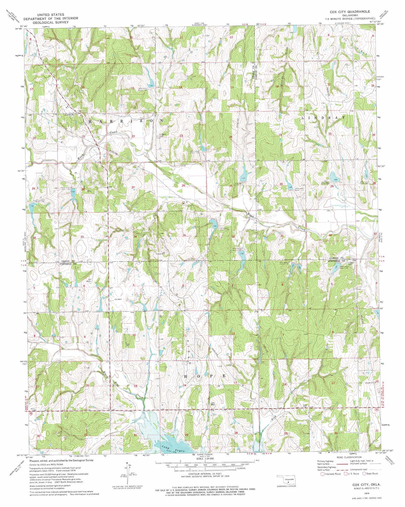
Cox City Topo Map Oklahoma
To zoom in, hover over the map of Cox City
USGS Topo Quad 34097f6 - 1:24,000 scale
| Topo Map Name: | Cox City |
| USGS Topo Quad ID: | 34097f6 |
| Print Size: | ca. 21 1/4" wide x 27" high |
| Southeast Coordinates: | 34.625° N latitude / 97.625° W longitude |
| Map Center Coordinates: | 34.6875° N latitude / 97.6875° W longitude |
| U.S. State: | OK |
| Filename: | o34097f6.jpg |
| Download Map JPG Image: | Cox City topo map 1:24,000 scale |
| Map Type: | Topographic |
| Topo Series: | 7.5´ |
| Map Scale: | 1:24,000 |
| Source of Map Images: | United States Geological Survey (USGS) |
| Alternate Map Versions: |
Cox City OK 1974, updated 1977 Download PDF Buy paper map Cox City OK 2009 Download PDF Buy paper map Cox City OK 2012 Download PDF Buy paper map Cox City OK 2016 Download PDF Buy paper map |
1:24,000 Topo Quads surrounding Cox City
East Ninnekah |
Alex |
Bradley |
Criner |
Stealy |
Rush Springs |
East Roaring Creek |
Lindsay Sw |
Lindsay |
Maysville |
Marlow |
Bray |
Cox City |
Purdy |
Elmore City North |
Duncan North |
Hope |
Lake Fuqua |
Pernell |
Elmore City South |
Duncan South |
Harrisburg |
Velma |
Ratliff City |
Tatums |
> Back to 34097e1 at 1:100,000 scale
> Back to 34096a1 at 1:250,000 scale
> Back to U.S. Topo Maps home
Cox City topo map: Gazetteer
Cox City: Dams
Ok Number Name 137094 Dam elevation 353m 1158′Oknoname 051050 Dam elevation 351m 1151′
Oknoname 137049 Dam elevation 360m 1181′
Oknoname 137050 Dam elevation 345m 1131′
Oknoname 137079 Dam elevation 350m 1148′
Oknoname 137082 Dam elevation 355m 1164′
Rush Creek Site 19 Dam elevation 347m 1138′
Rush Creek Site 20 Dam elevation 349m 1145′
Rush Creek Site 22 Dam elevation 353m 1158′
Rush Creek Site 23 Dam elevation 358m 1174′
Rush Creek Site 25 Dam elevation 336m 1102′
Rush Creek Site 27 Dam elevation 369m 1210′
Rush Creek Site 40 Dam elevation 334m 1095′
Rush Creek Site 41 Dam elevation 335m 1099′
Rush Creek Site 42 Dam elevation 331m 1085′
Rush Creek Site 46 Dam elevation 344m 1128′
Rush Creek Site Number 21 Dam elevation 370m 1213′
Upper Clear Boggy Number 27 Dam elevation 354m 1161′
Cox City: Populated Places
Cox City elevation 369m 1210′Cox City: Reservoirs
Oknoname 051050 Reservoir elevation 351m 1151′Oknoname 137049 Reservoir elevation 360m 1181′
Oknoname 137050 Reservoir elevation 345m 1131′
Oknoname 137079 Reservoir elevation 350m 1148′
Oknoname 137082 Reservoir elevation 355m 1164′
Oknoname 137094 Reservoir elevation 353m 1158′
Rush Creek Site 19 Reservoir elevation 347m 1138′
Rush Creek Site 20 Reservoir elevation 349m 1145′
Rush Creek Site 22 Reservoir elevation 353m 1158′
Rush Creek Site 23 Reservoir elevation 358m 1174′
Rush Creek Site 25 Reservoir elevation 336m 1102′
Rush Creek Site 27 Reservoir elevation 369m 1210′
Rush Creek Site 40 Reservoir elevation 334m 1095′
Rush Creek Site 41 Reservoir elevation 335m 1099′
Rush Creek Site 42 Reservoir elevation 331m 1085′
Rush Creek Site 46 Reservoir elevation 344m 1128′
Rush Creek Site Number 21 Reservoir elevation 370m 1213′
Upper Clear Boggy Number 27 Reservoir elevation 354m 1161′
Cox City: Streams
Fish Creek elevation 328m 1076′Cox City digital topo map on disk
Buy this Cox City topo map showing relief, roads, GPS coordinates and other geographical features, as a high-resolution digital map file on DVD: