Rush Springs Topo Map Oklahoma
To zoom in, hover over the map of Rush Springs
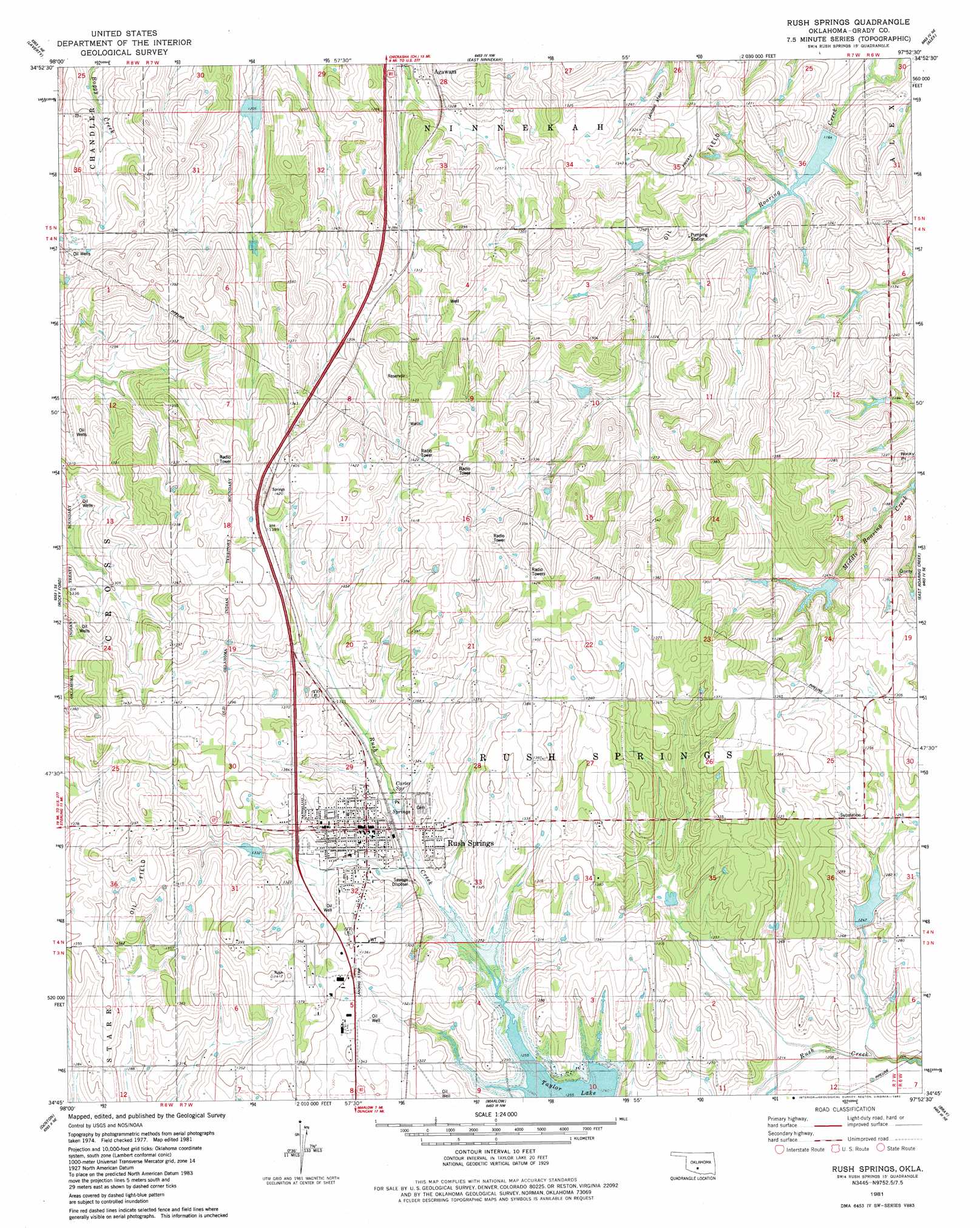
USGS Topo Quad 34097g8 - 1:24,000 scale
| Topo Map Name: | Rush Springs |
| USGS Topo Quad ID: | 34097g8 |
| Print Size: | ca. 21 1/4" wide x 27" high |
| Southeast Coordinates: | 34.75° N latitude / 97.875° W longitude |
| Map Center Coordinates: | 34.8125° N latitude / 97.9375° W longitude |
| U.S. State: | OK |
| Filename: | o34097g8.jpg |
| Download Map JPG Image: | Rush Springs topo map 1:24,000 scale |
| Map Type: | Topographic |
| Topo Series: | 7.5´ |
| Map Scale: | 1:24,000 |
| Source of Map Images: | United States Geological Survey (USGS) |
| Alternate Map Versions: |
Rush Springs SW OK 1975, updated 1976 Download PDF Buy paper map Rush Springs OK 1981, updated 1982 Download PDF Buy paper map Rush Springs OK 2010 Download PDF Buy paper map Rush Springs OK 2012 Download PDF Buy paper map Rush Springs OK 2016 Download PDF Buy paper map |
1:24,000 Topo Quads surrounding Rush Springs
Anadarko East |
Verden |
Chickasha |
Tabler |
Dibble |
Cyril |
Laverty |
East Ninnekah |
Alex |
Bradley |
Fletcher |
Rocky Ford |
Rush Springs |
East Roaring Creek |
Lindsay Sw |
Sterling |
Denton |
Marlow |
Bray |
Cox City |
Letitia |
Nellie |
Duncan North |
Hope |
Lake Fuqua |
> Back to 34097e1 at 1:100,000 scale
> Back to 34096a1 at 1:250,000 scale
> Back to U.S. Topo Maps home
Rush Springs topo map: Gazetteer
Rush Springs: Dams
Little Washita Site 13 Dam elevation 387m 1269′Little Washita Site 8 Dam elevation 370m 1213′
Little Washita Site 9 Dam elevation 367m 1204′
Roaring Creek Site 102 Dam elevation 396m 1299′
Roaring Creek Site 103 Dam elevation 387m 1269′
Roaring Creek Site 104 Dam elevation 367m 1204′
Roaring Creek Site 16a Dam elevation 379m 1243′
Roaring Creek Site 9 Dam elevation 355m 1164′
Rush Creek Site 3 Dam elevation 384m 1259′
Rush Creek Site 49 Dam elevation 402m 1318′
Rush Creek Site 5 Dam elevation 391m 1282′
Rush Creek Site 6 Dam elevation 385m 1263′
Rush Springs: Populated Places
Agawam elevation 376m 1233′Rush Springs elevation 412m 1351′
Rush Springs: Reservoirs
Little Washita Site 13 Reservoir elevation 387m 1269′Little Washita Site 8 Reservoir elevation 370m 1213′
Little Washita Site 9 Reservoir elevation 367m 1204′
Roaring Creek Site 102 Reservoir elevation 396m 1299′
Roaring Creek Site 103 Reservoir elevation 387m 1269′
Roaring Creek Site 104 Reservoir elevation 367m 1204′
Roaring Creek Site 16a Reservoir elevation 379m 1243′
Roaring Creek Site 9 Reservoir elevation 355m 1164′
Rush Creek Site 3 Reservoir elevation 384m 1259′
Rush Creek Site 49 Reservoir elevation 402m 1318′
Rush Creek Site 5 Reservoir elevation 391m 1282′
Rush Creek Site 6 Reservoir elevation 385m 1263′
Rush Springs: Springs
Carter Spring elevation 397m 1302′Rush Springs digital topo map on disk
Buy this Rush Springs topo map showing relief, roads, GPS coordinates and other geographical features, as a high-resolution digital map file on DVD: