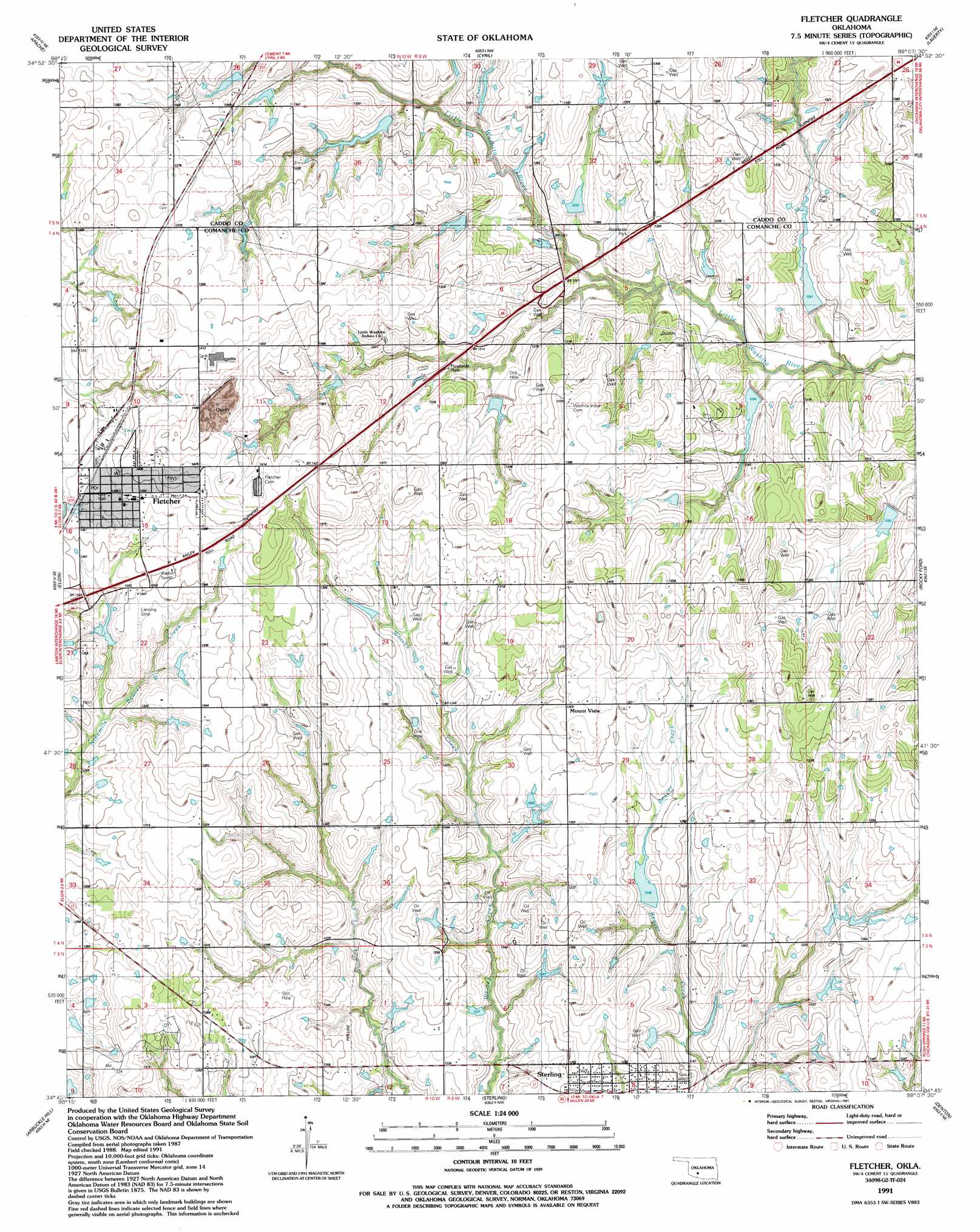
Fletcher Topo Map Oklahoma
To zoom in, hover over the map of Fletcher
USGS Topo Quad 34098g2 - 1:24,000 scale
| Topo Map Name: | Fletcher |
| USGS Topo Quad ID: | 34098g2 |
| Print Size: | ca. 21 1/4" wide x 27" high |
| Southeast Coordinates: | 34.75° N latitude / 98.125° W longitude |
| Map Center Coordinates: | 34.8125° N latitude / 98.1875° W longitude |
| U.S. State: | OK |
| Filename: | o34098g2.jpg |
| Download Map JPG Image: | Fletcher topo map 1:24,000 scale |
| Map Type: | Topographic |
| Topo Series: | 7.5´ |
| Map Scale: | 1:24,000 |
| Source of Map Images: | United States Geological Survey (USGS) |
| Alternate Map Versions: |
Fletcher OK 1956, updated 1959 Download PDF Buy paper map Fletcher OK 1956, updated 1976 Download PDF Buy paper map Fletcher OK 1991, updated 1991 Download PDF Buy paper map Fletcher OK 2010 Download PDF Buy paper map Fletcher OK 2012 Download PDF Buy paper map Fletcher OK 2016 Download PDF Buy paper map |
1:24,000 Topo Quads surrounding Fletcher
Fort Cobb |
Anadarko West |
Anadarko East |
Verden |
Chickasha |
Boone |
Apache |
Cyril |
Laverty |
East Ninnekah |
Richards Spur |
Elgin |
Fletcher |
Rocky Ford |
Rush Springs |
Fort Sill |
Arbuckle Hill |
Sterling |
Denton |
Marlow |
Lawton |
Ninemile Creek |
Letitia |
Nellie |
Duncan North |
> Back to 34098e1 at 1:100,000 scale
> Back to 34098a1 at 1:250,000 scale
> Back to U.S. Topo Maps home
Fletcher topo map: Gazetteer
Fletcher: Dams
Cleuts White Dam elevation 383m 1256′Little Washita Creek Site 19 Dam elevation 382m 1253′
Little Washita Creek Site 21 Dam elevation 391m 1282′
Little Washita Creek Site 22 Dam elevation 401m 1315′
Little Washita Creek Site 23 Dam elevation 394m 1292′
Little Washita Creek Site 24 Dam elevation 389m 1276′
Little Washita Creek Site 28 Dam elevation 384m 1259′
Little Washita Creek Site 29 Dam elevation 411m 1348′
Little Washita Creek Site 31 Dam elevation 371m 1217′
Little Washita River Site 30 Dam elevation 379m 1243′
Lonell Hays Dam elevation 393m 1289′
Oknoname 031009 Dam elevation 378m 1240′
Oknoname 031010 Dam elevation 376m 1233′
Oknoname 031015 Dam elevation 409m 1341′
Fletcher: Populated Places
Fletcher elevation 422m 1384′Mount View elevation 399m 1309′
Sterling elevation 375m 1230′
Fletcher: Reservoirs
Cletus White Reservoir elevation 383m 1256′Little Washita Creek Site 19 Reservoir elevation 382m 1253′
Little Washita Creek Site 21 Reservoir elevation 391m 1282′
Little Washita Creek Site 22 Reservoir elevation 401m 1315′
Little Washita Creek Site 23 Reservoir elevation 394m 1292′
Little Washita Creek Site 24 Reservoir elevation 389m 1276′
Little Washita Creek Site 28 Reservoir elevation 384m 1259′
Little Washita Creek Site 29 Reservoir elevation 411m 1348′
Little Washita Creek Site 31 Reservoir elevation 371m 1217′
Little Washita River Site 30 Reservoir elevation 379m 1243′
Lonell Hays Reservoir elevation 393m 1289′
Oknoname 031009 Reservoir elevation 378m 1240′
Oknoname 031010 Reservoir elevation 376m 1233′
Oknoname 031015 Reservoir elevation 409m 1341′
Fletcher: Streams
Chetonia Creek elevation 379m 1243′Fletcher digital topo map on disk
Buy this Fletcher topo map showing relief, roads, GPS coordinates and other geographical features, as a high-resolution digital map file on DVD: