Clarendon Sw Topo Map Texas
To zoom in, hover over the map of Clarendon Sw
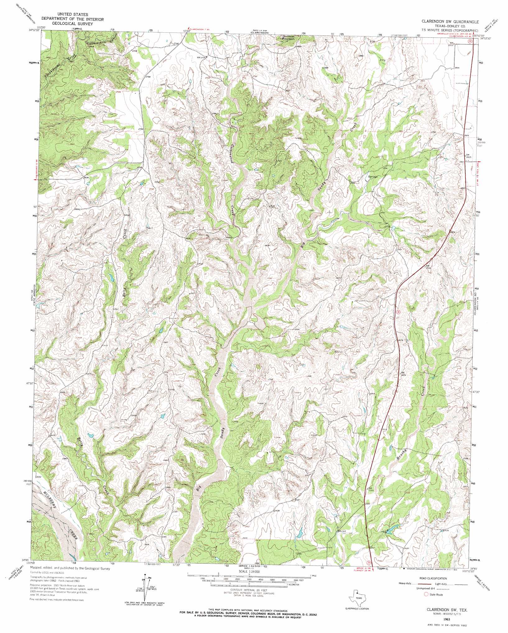
USGS Topo Quad 34100g8 - 1:24,000 scale
| Topo Map Name: | Clarendon Sw |
| USGS Topo Quad ID: | 34100g8 |
| Print Size: | ca. 21 1/4" wide x 27" high |
| Southeast Coordinates: | 34.75° N latitude / 100.875° W longitude |
| Map Center Coordinates: | 34.8125° N latitude / 100.9375° W longitude |
| U.S. State: | TX |
| Filename: | o34100g8.jpg |
| Download Map JPG Image: | Clarendon Sw topo map 1:24,000 scale |
| Map Type: | Topographic |
| Topo Series: | 7.5´ |
| Map Scale: | 1:24,000 |
| Source of Map Images: | United States Geological Survey (USGS) |
| Alternate Map Versions: |
Clarendon SW TX 1963, updated 1966 Download PDF Buy paper map Clarendon SW TX 2010 Download PDF Buy paper map Clarendon SW TX 2012 Download PDF Buy paper map Clarendon SW TX 2016 Download PDF Buy paper map |
1:24,000 Topo Quads surrounding Clarendon Sw
Goodnight |
Ashtola |
Roach Ranch |
Griffin Ranch |
Troublesome Creek |
Blue Hole Springs |
Buffalo Arroyo |
Clarendon |
Lelia Lake |
Lelia Lake Creek |
Paloduro |
Tate Arroyo |
Clarendon Sw |
Clarendon Se |
Hedley |
Hardscrabble Creek |
Willow Arroyo |
Brice |
Lesley |
Memphis Nw |
Indian Peak |
Schott Mountain |
Hughes Canyon |
Heel Fly Draw |
Plaska |
> Back to 34100e1 at 1:100,000 scale
> Back to 34100a1 at 1:250,000 scale
> Back to U.S. Topo Maps home
Clarendon Sw topo map: Gazetteer
Clarendon Sw: Dams
Soil Conservation Service Site 1 Dam elevation 717m 2352′Soil Conservation Service Site 2 Dam elevation 736m 2414′
Clarendon Sw: Reservoirs
Soil Conservation Service Site 1 Reservoir elevation 717m 2352′Soil Conservation Service Site 2 Reservoir elevation 736m 2414′
Clarendon Sw: Streams
Cottonwood Creek elevation 729m 2391′Clarendon Sw: Valleys
Troublesome Canyon elevation 766m 2513′Clarendon Sw digital topo map on disk
Buy this Clarendon Sw topo map showing relief, roads, GPS coordinates and other geographical features, as a high-resolution digital map file on DVD: