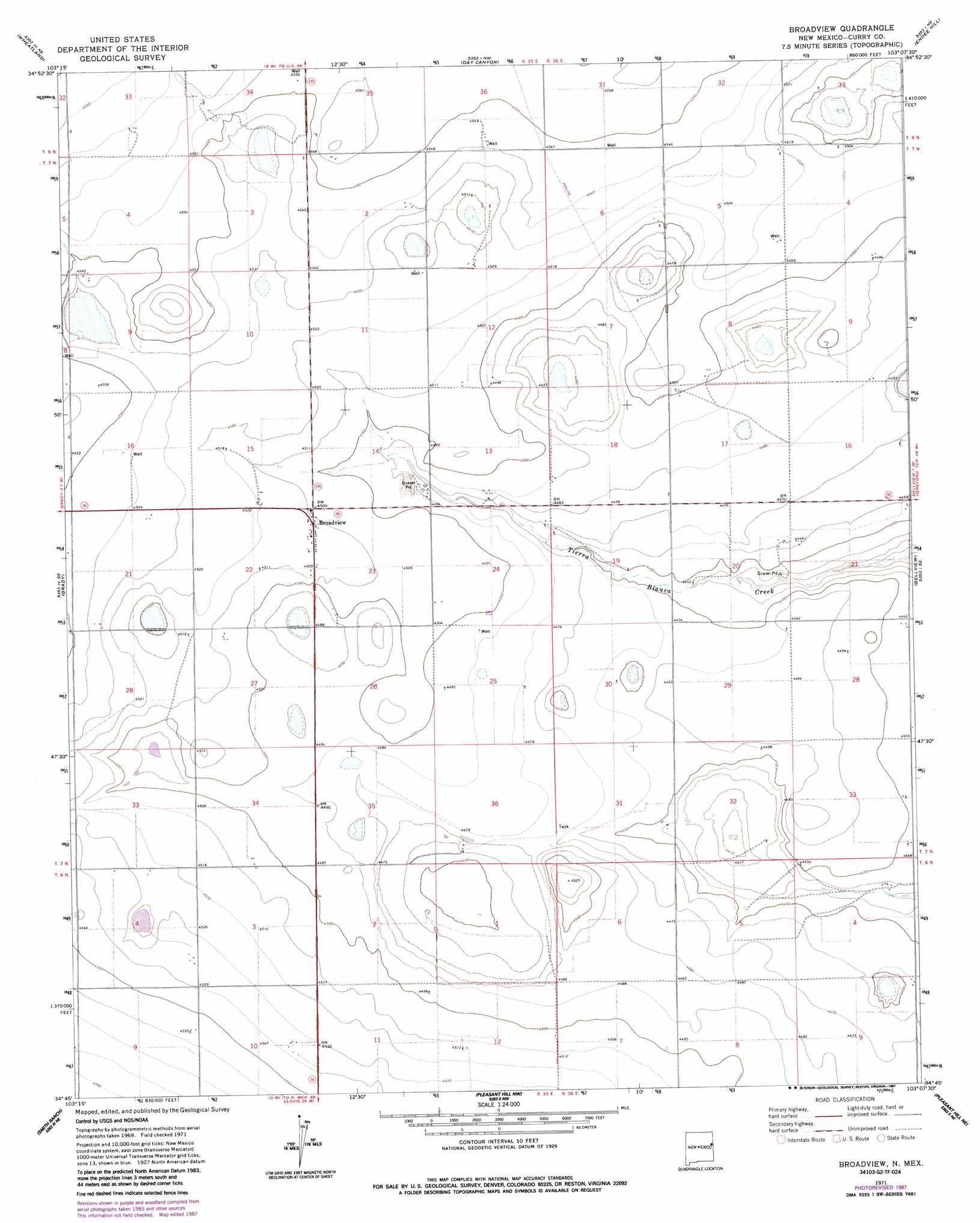
Broadview Topo Map New Mexico
To zoom in, hover over the map of Broadview
USGS Topo Quad 34103g2 - 1:24,000 scale
| Topo Map Name: | Broadview |
| USGS Topo Quad ID: | 34103g2 |
| Print Size: | ca. 21 1/4" wide x 27" high |
| Southeast Coordinates: | 34.75° N latitude / 103.125° W longitude |
| Map Center Coordinates: | 34.8125° N latitude / 103.1875° W longitude |
| U.S. State: | NM |
| Filename: | o34103g2.jpg |
| Download Map JPG Image: | Broadview topo map 1:24,000 scale |
| Map Type: | Topographic |
| Topo Series: | 7.5´ |
| Map Scale: | 1:24,000 |
| Source of Map Images: | United States Geological Survey (USGS) |
| Alternate Map Versions: |
Broadview NM 1971, updated 1974 Download PDF Buy paper map Broadview NM 1971, updated 1987 Download PDF Buy paper map Broadview NM 2010 Download PDF Buy paper map Broadview NM 2013 Download PDF Buy paper map Broadview NM 2017 Download PDF Buy paper map |
1:24,000 Topo Quads surrounding Broadview
Bedford Hill |
San Jon |
Riley Camp |
Rock Camp |
Sand Point |
Apache Canyon |
Wheatland |
Day Canyon |
Endee Hill |
Mustang Lake |
Grady Sw |
Grady |
Broadview |
Bellview |
Garcia Lake |
Hammond Ranch |
Smith Ranch |
Pleasant Hill Nw |
Pleasant Hill Ne |
Rhea |
Hammond Ranch Sw |
Garrett Ranch |
Ned Houk Park |
Pleasant Hill |
Bovina |
> Back to 34103e1 at 1:100,000 scale
> Back to 34102a1 at 1:250,000 scale
> Back to U.S. Topo Maps home
Broadview topo map: Gazetteer
Broadview: Populated Places
Broadview elevation 1376m 4514′Broadview: Post Offices
Broadview Post Office elevation 1376m 4514′Broadview: Wells
10101 Water Well elevation 1380m 4527′10204 Water Well elevation 1393m 4570′
10221 Water Well elevation 1376m 4514′
10223 Water Well elevation 1387m 4550′
10225 Water Well elevation 1368m 4488′
10226 Water Well elevation 1374m 4507′
10230 Water Well elevation 1378m 4520′
10246 Water Well elevation 1374m 4507′
10251 Water Well elevation 1355m 4445′
10765 Water Well elevation 1384m 4540′
10917 Water Well elevation 1381m 4530′
10923 Water Well elevation 1387m 4550′
10924 Water Well elevation 1365m 4478′
10925 Water Well elevation 1376m 4514′
10926 Water Well elevation 1361m 4465′
10928 Water Well elevation 1368m 4488′
10931 Water Well elevation 1366m 4481′
11447 Water Well elevation 1378m 4520′
11448 Water Well elevation 1372m 4501′
11449 Water Well elevation 1388m 4553′
11453 Water Well elevation 1358m 4455′
11475 Water Well elevation 1378m 4520′
11476 Water Well elevation 1367m 4484′
11477 Water Well elevation 1365m 4478′
11478 Water Well elevation 1357m 4452′
11482 Water Well elevation 1388m 4553′
11488 Water Well elevation 1374m 4507′
11503 Water Well elevation 1389m 4557′
11506 Water Well elevation 1372m 4501′
Broadview digital topo map on disk
Buy this Broadview topo map showing relief, roads, GPS coordinates and other geographical features, as a high-resolution digital map file on DVD: