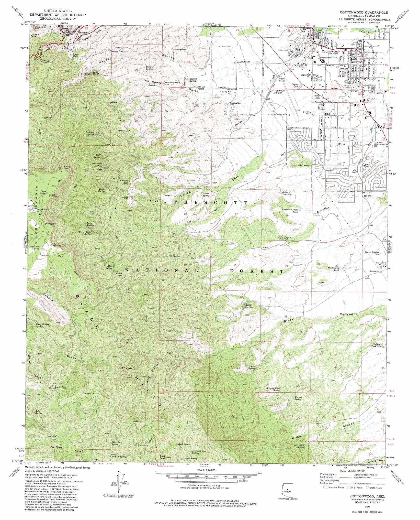
Cottonwood Topo Map Arizona
To zoom in, hover over the map of Cottonwood
USGS Topo Quad 34112f1 - 1:24,000 scale
| Topo Map Name: | Cottonwood |
| USGS Topo Quad ID: | 34112f1 |
| Print Size: | ca. 21 1/4" wide x 27" high |
| Southeast Coordinates: | 34.625° N latitude / 112° W longitude |
| Map Center Coordinates: | 34.6875° N latitude / 112.0625° W longitude |
| U.S. State: | AZ |
| Filename: | o34112f1.jpg |
| Download Map JPG Image: | Cottonwood topo map 1:24,000 scale |
| Map Type: | Topographic |
| Topo Series: | 7.5´ |
| Map Scale: | 1:24,000 |
| Source of Map Images: | United States Geological Survey (USGS) |
| Alternate Map Versions: |
Cottonwood AZ 1973, updated 1977 Download PDF Buy paper map Cottonwood AZ 1973, updated 1983 Download PDF Buy paper map Cottonwood AZ 1973, updated 1983 Download PDF Buy paper map Cottonwood AZ 2012 Download PDF Buy paper map Cottonwood AZ 2014 Download PDF Buy paper map |
| FStopo: | US Forest Service topo Cottonwood is available: Download FStopo PDF Download FStopo TIF |
1:24,000 Topo Quads surrounding Cottonwood
Hell Point |
Perkinsville |
Sycamore Basin |
Loy Butte |
Wilson Mountain |
King Canyon |
Munds Draw |
Clarkdale |
Page Springs |
Sedona |
Prescott Valley North |
Hickey Mountain |
Cottonwood |
Cornville |
Lake Montezuma |
Prescott Valley South |
Humboldt |
Cherry |
Middle Verde |
Camp Verde |
Poland Junction |
Mayer |
Estler Peak |
Arnold Mesa |
Horner Mountain |
> Back to 34112e1 at 1:100,000 scale
> Back to 34112a1 at 1:250,000 scale
> Back to U.S. Topo Maps home
Cottonwood topo map: Gazetteer
Cottonwood: Airports
Cottonwood Airport elevation 1082m 3549′Marcus J Lawrence Medical Center Heliport elevation 1060m 3477′
Cottonwood: Canals
Cottonwood Ditch elevation 1005m 3297′Cottonwood: Mines
Brindle Pup Mine elevation 1999m 6558′C and J Shaft elevation 1496m 4908′
Copper Chief Mine elevation 1713m 5620′
Gadsden Shaft elevation 1438m 4717′
Iron King Mine elevation 1720m 5643′
Jerome-Del Monte Shaft elevation 1321m 4333′
United Verde Mine elevation 1638m 5374′
Verde Central Shaft elevation 1673m 5488′
Verde Combination Shaft elevation 1428m 4685′
Cottonwood: Parks
Cottonwood Kids Park elevation 1023m 3356′Garrison Park elevation 1041m 3415′
Lions Club Park elevation 1025m 3362′
Cottonwood: Populated Places
Clemenceau elevation 1058m 3471′Cottonwood elevation 1014m 3326′
Jerome elevation 1544m 5065′
Verde Village elevation 1054m 3458′
Cottonwood: Post Offices
Cottonwood Post Office elevation 1032m 3385′Cottonwood: Reservoirs
Christina Draw Tank elevation 1118m 3667′Dry Lake Tank elevation 2323m 7621′
Goddard Tank Number One elevation 1097m 3599′
Goddard Tank Number Two elevation 1152m 3779′
Montezuma Tank elevation 1102m 3615′
Trick Tank elevation 1908m 6259′
Trick Tank elevation 1987m 6519′
Trick Tank elevation 1950m 6397′
Cottonwood: Springs
Alex Spring elevation 1843m 6046′Allen Spring elevation 1854m 6082′
Ash Spring elevation 1859m 6099′
Baltimore Spring elevation 1833m 6013′
Black Canyon Spring elevation 1989m 6525′
Blowout Spring elevation 1806m 5925′
Boat Spring elevation 1804m 5918′
Brushy Wash Spring elevation 1258m 4127′
Buck Spring elevation 1829m 6000′
Cliff Spring elevation 1811m 5941′
Columbine Spring elevation 1743m 5718′
Copper Chief Spring elevation 1880m 6167′
Fields Spring elevation 1663m 5456′
Goat Camp Springs elevation 1334m 4376′
Haskell Spring elevation 1189m 3900′
Hasket Spring elevation 1363m 4471′
Indian Spring elevation 1320m 4330′
Little Ranch Spring elevation 1359m 4458′
Lower Slick Rock Spring elevation 1780m 5839′
Maverick Gap Spring elevation 1832m 6010′
Morgan Spring elevation 1259m 4130′
Oak Spring elevation 1776m 5826′
Oxbow Spring elevation 1318m 4324′
Quail Springs elevation 1271m 4169′
Rock Spring elevation 1276m 4186′
Silver Spring elevation 1882m 6174′
Slick Rock Spring elevation 1816m 5958′
Twin Springs elevation 1879m 6164′
Cottonwood: Streams
Blowout Creek elevation 1007m 3303′Oak Wash elevation 1009m 3310′
Cottonwood: Summits
Goat Peak elevation 2024m 6640′Cottonwood: Valleys
Burnt Canyon elevation 1862m 6108′Christina Draw elevation 1032m 3385′
Del Monte Gulch elevation 1094m 3589′
Gaddes Canyon elevation 1826m 5990′
Hull Canyon elevation 1467m 4812′
Silver Spring Gulch elevation 1098m 3602′
Ward Pocket elevation 1450m 4757′
Cottonwood: Wells
Pasture Well elevation 1155m 3789′Cottonwood digital topo map on disk
Buy this Cottonwood topo map showing relief, roads, GPS coordinates and other geographical features, as a high-resolution digital map file on DVD: