Pikeville Topo Map Tennessee
To zoom in, hover over the map of Pikeville
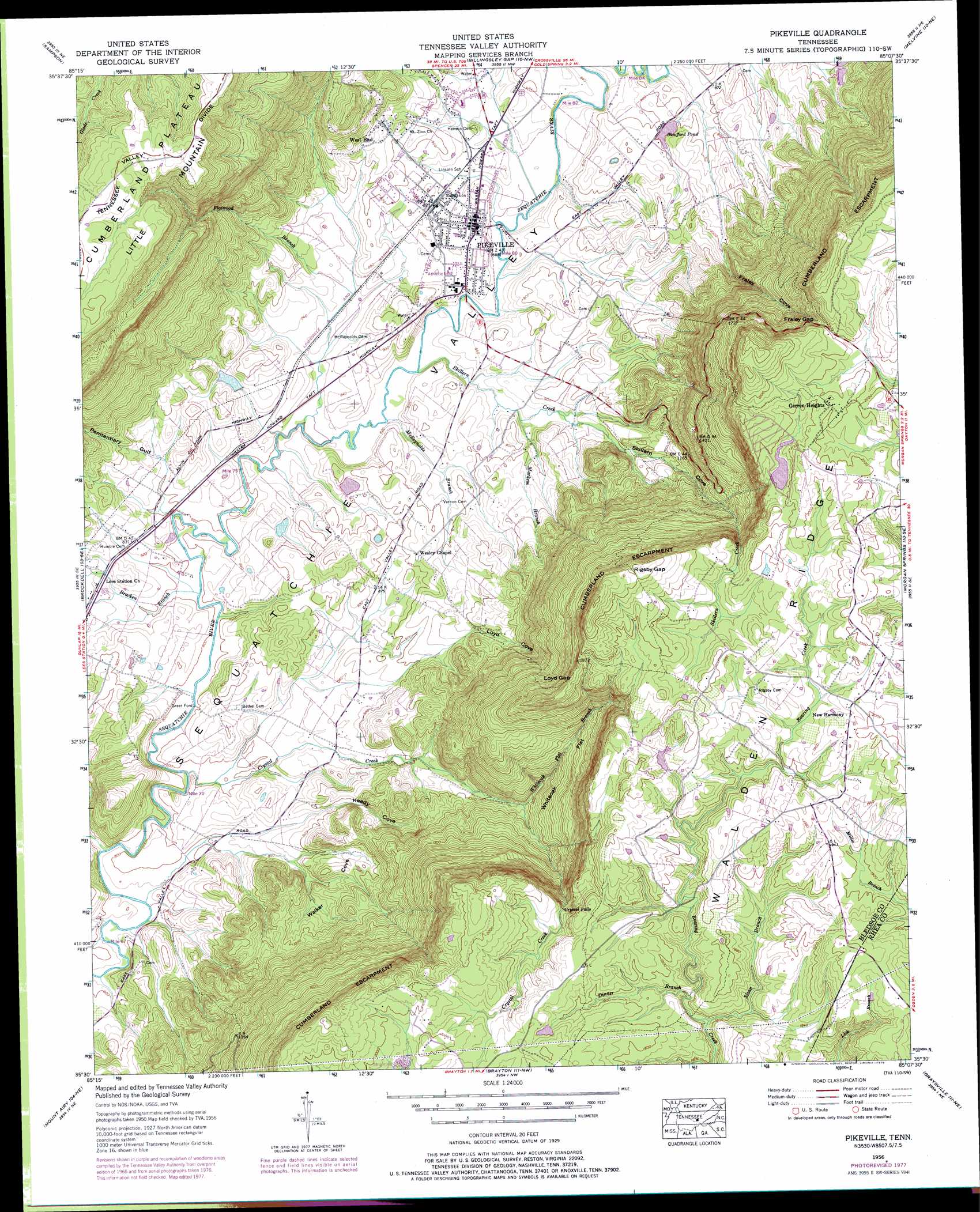
USGS Topo Quad 35085e2 - 1:24,000 scale
| Topo Map Name: | Pikeville |
| USGS Topo Quad ID: | 35085e2 |
| Print Size: | ca. 21 1/4" wide x 27" high |
| Southeast Coordinates: | 35.5° N latitude / 85.125° W longitude |
| Map Center Coordinates: | 35.5625° N latitude / 85.1875° W longitude |
| U.S. State: | TN |
| Filename: | o35085e2.jpg |
| Download Map JPG Image: | Pikeville topo map 1:24,000 scale |
| Map Type: | Topographic |
| Topo Series: | 7.5´ |
| Map Scale: | 1:24,000 |
| Source of Map Images: | United States Geological Survey (USGS) |
| Alternate Map Versions: |
Pikeville TN 1935 Download PDF Buy paper map Pikeville TN 1956, updated 1958 Download PDF Buy paper map Pikeville TN 1956, updated 1958 Download PDF Buy paper map Pikeville TN 1956, updated 1974 Download PDF Buy paper map Pikeville TN 1956, updated 1978 Download PDF Buy paper map Pikeville TN 1956, updated 1978 Download PDF Buy paper map Pikeville TN 2010 Download PDF Buy paper map Pikeville TN 2013 Download PDF Buy paper map Pikeville TN 2016 Download PDF Buy paper map |
1:24,000 Topo Quads surrounding Pikeville
Bald Knob |
Lonewood |
Herbert Domain |
Vandever |
Grassy Cove |
Spencer |
Sampson |
Billingsley Gap |
Melvine |
Pennine |
Smartt Mountain |
Brockdell |
Pikeville |
Morgan Springs |
Evensville |
Savage Point |
Mount Airy |
Brayton |
Graysville |
Big Spring |
Daus |
Henson Gap |
Soddy |
Grasshopper Creek |
Birchwood |
> Back to 35085e1 at 1:100,000 scale
> Back to 35084a1 at 1:250,000 scale
> Back to U.S. Topo Maps home
Pikeville topo map: Gazetteer
Pikeville: Crossings
Greer Ford elevation 238m 780′Pikeville: Dams
Abc Dam elevation 617m 2024′Burns Lake Dam elevation 256m 839′
Twin Lakes Number Three Dam elevation 280m 918′
Pikeville: Falls
Crystal Falls elevation 533m 1748′Pikeville: Flats
Whiteoak Flat elevation 420m 1377′Pikeville: Gaps
Fraley Gap elevation 555m 1820′Loyd Gap elevation 599m 1965′
Rigsby Gap elevation 641m 2103′
Pikeville: Lakes
Swafford Pond elevation 270m 885′Pikeville: Mines
Fraley Gap Mine elevation 617m 2024′Pikeville: Populated Places
Gerren Heights elevation 615m 2017′New Harmony elevation 602m 1975′
Pikeville elevation 262m 859′
West End elevation 287m 941′
Pikeville: Reservoirs
Abc Lake elevation 617m 2024′Burns Lake elevation 256m 839′
Twin Lakes Number Three Lake elevation 280m 918′
Pikeville: Springs
Loyd Spring elevation 334m 1095′Pikeville: Streams
Bracken Branch elevation 239m 784′Crystal Creek elevation 236m 774′
Dinner Branch elevation 543m 1781′
Flatwood Branch elevation 244m 800′
Markem Branch elevation 254m 833′
McReynolds Branch elevation 247m 810′
Skillern Creek elevation 247m 810′
Sloan Branch elevation 539m 1768′
Spring Branch elevation 236m 774′
Whiteoak Flat Branch elevation 278m 912′
Pikeville: Valleys
Fraley Cove elevation 304m 997′Keedy Cove elevation 262m 859′
Loyd Cove elevation 297m 974′
Penitentiary Gulf elevation 248m 813′
Skillern Cove elevation 264m 866′
The Penitentiary elevation 507m 1663′
Walker Cove elevation 289m 948′
Pikeville digital topo map on disk
Buy this Pikeville topo map showing relief, roads, GPS coordinates and other geographical features, as a high-resolution digital map file on DVD: