Soddy Topo Map Tennessee
To zoom in, hover over the map of Soddy
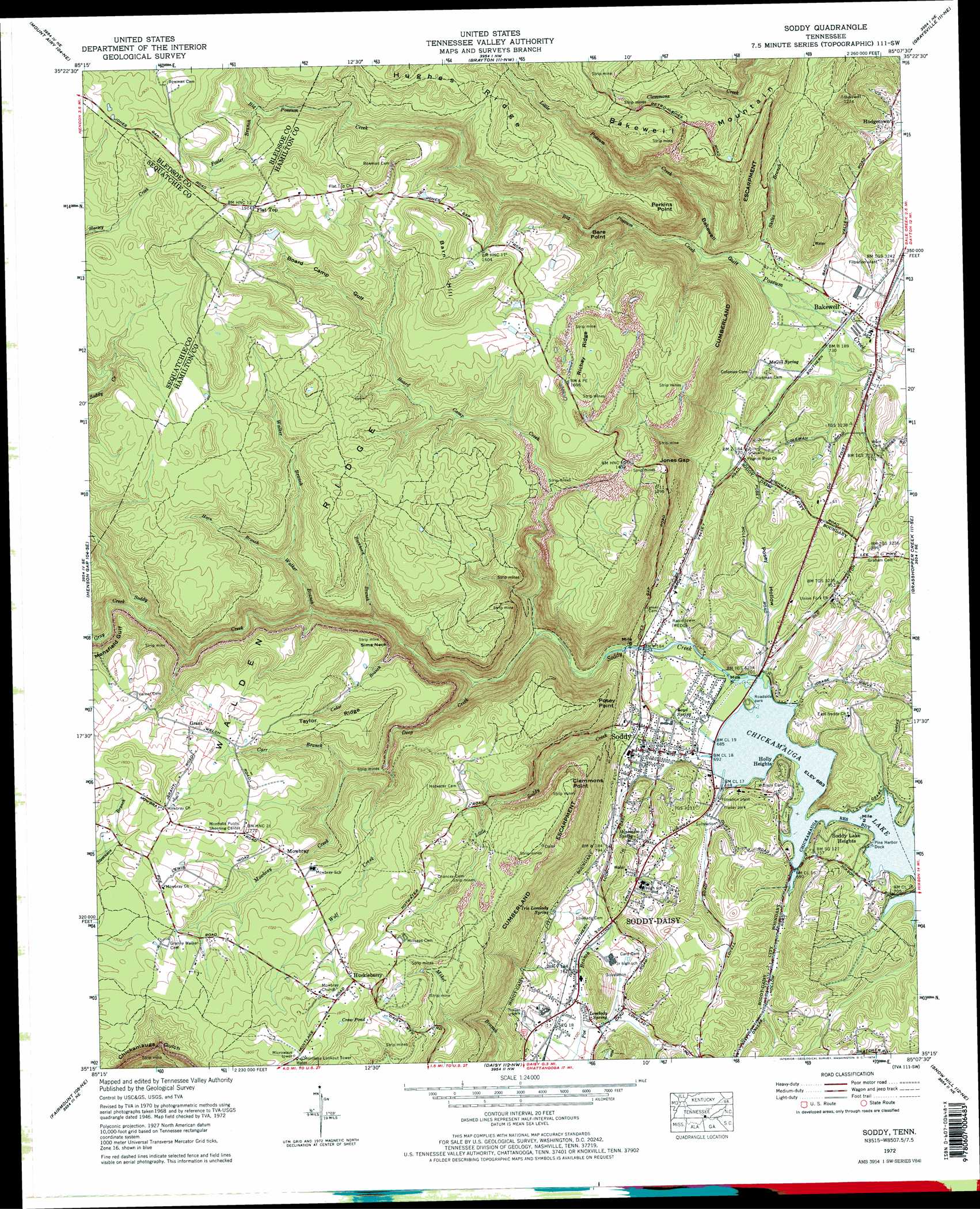
USGS Topo Quad 35085c2 - 1:24,000 scale
| Topo Map Name: | Soddy |
| USGS Topo Quad ID: | 35085c2 |
| Print Size: | ca. 21 1/4" wide x 27" high |
| Southeast Coordinates: | 35.25° N latitude / 85.125° W longitude |
| Map Center Coordinates: | 35.3125° N latitude / 85.1875° W longitude |
| U.S. State: | TN |
| Filename: | o35085c2.jpg |
| Download Map JPG Image: | Soddy topo map 1:24,000 scale |
| Map Type: | Topographic |
| Topo Series: | 7.5´ |
| Map Scale: | 1:24,000 |
| Source of Map Images: | United States Geological Survey (USGS) |
| Alternate Map Versions: |
Soddy TN 1935 Download PDF Buy paper map Soddy TN 1946, updated 1960 Download PDF Buy paper map Soddy TN 1946, updated 1965 Download PDF Buy paper map Soddy TN 1947, updated 1947 Download PDF Buy paper map Soddy TN 1972, updated 1974 Download PDF Buy paper map Soddy TN 1972, updated 1974 Download PDF Buy paper map Soddy TN 2010 Download PDF Buy paper map Soddy TN 2013 Download PDF Buy paper map Soddy TN 2016 Download PDF Buy paper map |
1:24,000 Topo Quads surrounding Soddy
Smartt Mountain |
Brockdell |
Pikeville |
Morgan Springs |
Evensville |
Savage Point |
Mount Airy |
Brayton |
Graysville |
Big Spring |
Daus |
Henson Gap |
Soddy |
Grasshopper Creek |
Birchwood |
Ketner Gap |
Fairmount |
Daisy |
Snow Hill |
South Cleveland |
Wauhatchie |
Chattanooga |
East Chattanooga |
Ooltewah |
Mcdonald |
> Back to 35085a1 at 1:100,000 scale
> Back to 35084a1 at 1:250,000 scale
> Back to U.S. Topo Maps home
Soddy topo map: Gazetteer
Soddy: Capes
Bare Point elevation 412m 1351′Clemmons Point elevation 469m 1538′
Perkins Point elevation 456m 1496′
Posey Point elevation 415m 1361′
Sims Neck elevation 432m 1417′
Soddy: Gaps
Jones Gap elevation 429m 1407′Soddy: Lakes
Crow Pond elevation 551m 1807′Soddy: Mines
Big Soddy Number Seven Mine elevation 411m 1348′Big Soddy Number Three Mine elevation 421m 1381′
Burchard Mine elevation 443m 1453′
Daisy Mine elevation 473m 1551′
Hatfield and Luttrell Mine elevation 485m 1591′
Luther Milligan Mine elevation 426m 1397′
Soddy Number One Mine elevation 484m 1587′
Soddy: Parks
Northend Ball Park elevation 210m 688′Soddy Marine Park elevation 208m 682′
Soddy Municipal Park elevation 210m 688′
Soddy: Populated Places
Bakewell elevation 223m 731′Flat Top elevation 584m 1916′
Grant elevation 520m 1706′
Green Gables Mobile Home Park elevation 218m 715′
Harrison Trailer Park elevation 219m 718′
Hodgetown elevation 252m 826′
Holly Heights elevation 237m 777′
Huckleberry elevation 537m 1761′
J And B Mobile Home Park elevation 217m 711′
Mountain Shade Mobile Home Park elevation 251m 823′
Mowbray elevation 507m 1663′
North Soddy elevation 212m 695′
Pine Harbor Heights elevation 225m 738′
Soddy elevation 229m 751′
Soddy Lake Heights elevation 246m 807′
Soddy: Post Offices
Soddy Post Office elevation 231m 757′Soddy: Ridges
Hughes Ridge elevation 551m 1807′Richey Ridge elevation 507m 1663′
Taylor Ridge elevation 501m 1643′
Soddy: Springs
Hineman Spring elevation 246m 807′Iris Lovelady Spring elevation 260m 853′
Long Springs elevation 208m 682′
Lovelady Spring elevation 222m 728′
Loyd Spring elevation 215m 705′
McGill Spring elevation 228m 748′
Soddy: Streams
Big Possum Creek elevation 260m 853′Board Camp Creek elevation 249m 816′
Buckhort Branch elevation 322m 1056′
Carr Branch elevation 416m 1364′
Cedar Branch elevation 313m 1026′
Deep Creek elevation 270m 885′
Foster Branch elevation 485m 1591′
Gray Creek elevation 398m 1305′
Horn Branch elevation 408m 1338′
Little Possum Creek elevation 260m 853′
Little Soddy Creek elevation 210m 688′
Mowbray Creek elevation 417m 1368′
Skiles Branch elevation 220m 721′
Walker Branch elevation 358m 1174′
Wolf Creek elevation 396m 1299′
Soddy: Summits
Bakewell Mountain elevation 471m 1545′Barn Hill elevation 555m 1820′
Soddy: Valleys
Bakewell Gulf elevation 248m 813′Board Camp Gulf elevation 447m 1466′
Mansfield Gulf elevation 401m 1315′
Posey Hollow elevation 214m 702′
Soddy digital topo map on disk
Buy this Soddy topo map showing relief, roads, GPS coordinates and other geographical features, as a high-resolution digital map file on DVD: