Paden Topo Map Oklahoma
To zoom in, hover over the map of Paden
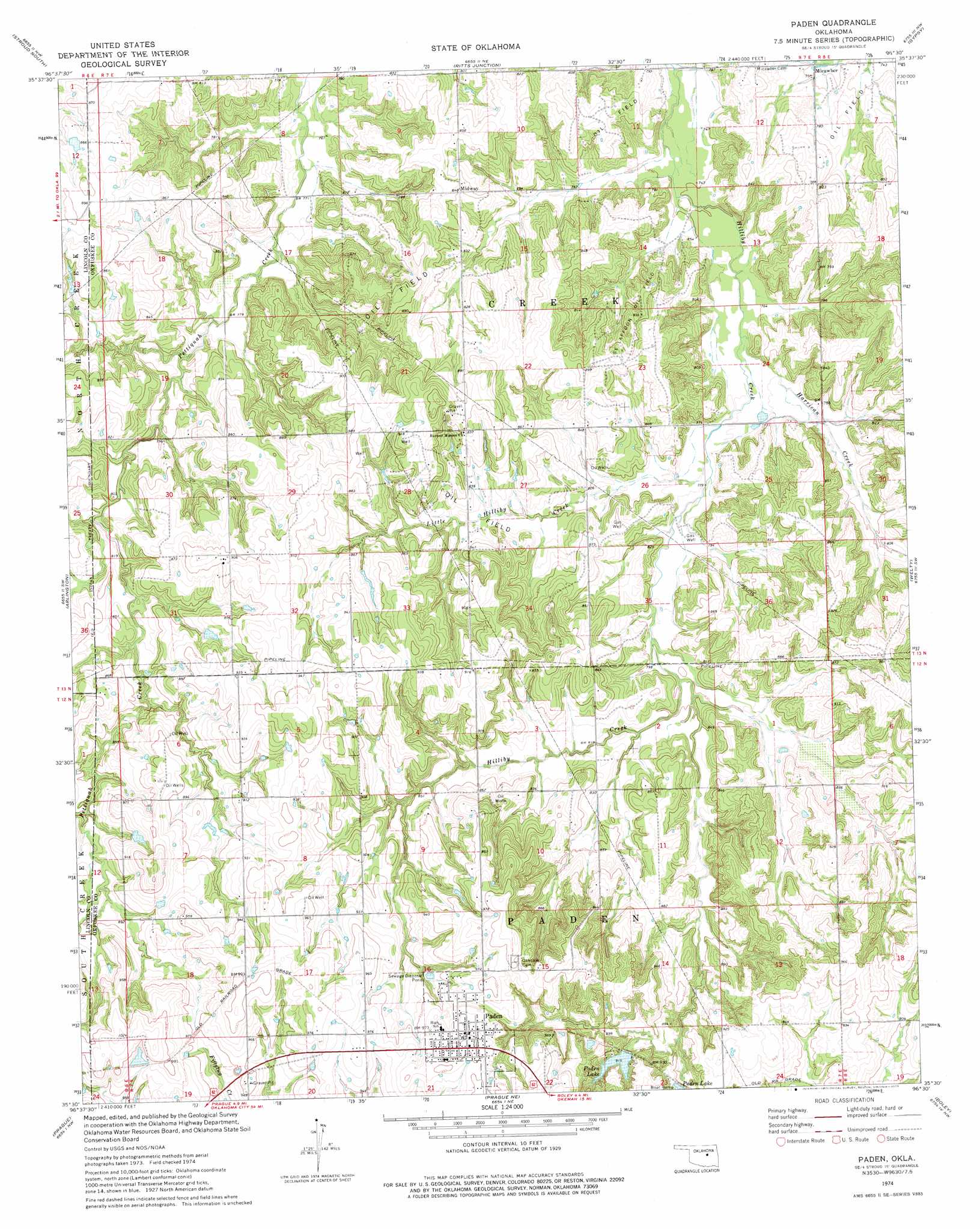
USGS Topo Quad 35096e5 - 1:24,000 scale
| Topo Map Name: | Paden |
| USGS Topo Quad ID: | 35096e5 |
| Print Size: | ca. 21 1/4" wide x 27" high |
| Southeast Coordinates: | 35.5° N latitude / 96.5° W longitude |
| Map Center Coordinates: | 35.5625° N latitude / 96.5625° W longitude |
| U.S. State: | OK |
| Filename: | o35096e5.jpg |
| Download Map JPG Image: | Paden topo map 1:24,000 scale |
| Map Type: | Topographic |
| Topo Series: | 7.5´ |
| Map Scale: | 1:24,000 |
| Source of Map Images: | United States Geological Survey (USGS) |
| Alternate Map Versions: |
Paden OK 1974, updated 1977 Download PDF Buy paper map Paden OK 2010 Download PDF Buy paper map Paden OK 2012 Download PDF Buy paper map Paden OK 2016 Download PDF Buy paper map |
1:24,000 Topo Quads surrounding Paden
Kendrick |
Stroud North |
Depew |
Bristow |
Slick |
Davenport |
Stroud South |
Ritts Junction |
Gypsy |
Newby |
Sparks |
Arlington |
Paden |
Welty |
Mason |
Shawnee Ne |
Prague |
Prague Ne |
Boley |
Okemah |
Earlsboro |
Prague Sw |
Prague Se |
Cromwell |
Okemah Se |
> Back to 35096e1 at 1:100,000 scale
> Back to 35096a1 at 1:250,000 scale
> Back to U.S. Topo Maps home
Paden topo map: Gazetteer
Paden: Dams
Okfuskee Tributaries Site H-1 Dam elevation 242m 793′Okfuskee Tributaries Site H-10 Dam elevation 232m 761′
Okfuskee Tributaries Site H-3 Dam elevation 253m 830′
Okfuskee Tributaries Site H-4 Dam elevation 254m 833′
Okfuskee Tributaries Site H-5 Dam elevation 253m 830′
Okfuskee Tributaries Site H-6 Dam elevation 256m 839′
Okfuskee Tributaries Site H-7 Dam elevation 256m 839′
Okfuskee Tributaries Site H-8 Dam elevation 280m 918′
Oknoname 107014 Dam elevation 281m 921′
Oknoname 107015 Dam elevation 266m 872′
Oknoname 107016 Dam elevation 265m 869′
Oknoname 107017 Dam elevation 267m 875′
Paden Lake Number 1 Dam elevation 276m 905′
Paden Lake Number 2 Dam elevation 270m 885′
Paden: Oilfields
Southeast Laffoon Oil Field elevation 257m 843′Paden: Populated Places
Micawber elevation 228m 748′Midway elevation 260m 853′
Paden elevation 304m 997′
Sac and Fox Agency (historical) elevation 274m 898′
Paden: Reservoirs
Okfuskee Tributaries Site H-1 Reservoir elevation 242m 793′Okfuskee Tributaries Site H-10 Reservoir elevation 232m 761′
Okfuskee Tributaries Site H-3 Reservoir elevation 253m 830′
Okfuskee Tributaries Site H-4 Reservoir elevation 254m 833′
Okfuskee Tributaries Site H-5 Reservoir elevation 253m 830′
Okfuskee Tributaries Site H-6 Reservoir elevation 256m 839′
Okfuskee Tributaries Site H-7 Reservoir elevation 256m 839′
Okfuskee Tributaries Site H-8 Reservoir elevation 280m 918′
Oknoname 107014 Reservoir elevation 281m 921′
Oknoname 107015 Reservoir elevation 266m 872′
Oknoname 107016 Reservoir elevation 265m 869′
Oknoname 107017 Reservoir elevation 267m 875′
Paden Lake elevation 271m 889′
Paden Lake elevation 280m 918′
Paden Lake Number 1 elevation 276m 905′
Paden Lake Number 2 elevation 270m 885′
Paden: Streams
Harrican Creek elevation 232m 761′Little Hilliby Creek elevation 236m 774′
Paden digital topo map on disk
Buy this Paden topo map showing relief, roads, GPS coordinates and other geographical features, as a high-resolution digital map file on DVD: