Sacaton Draw Topo Map New Mexico
To zoom in, hover over the map of Sacaton Draw
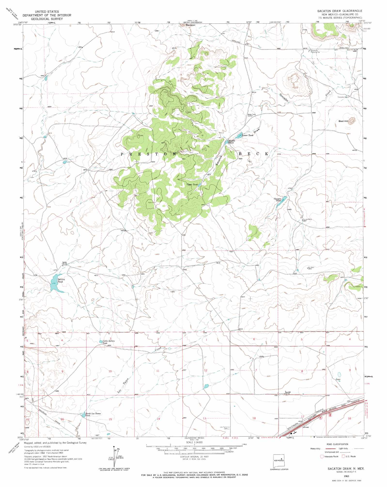
USGS Topo Quad 35104a5 - 1:24,000 scale
| Topo Map Name: | Sacaton Draw |
| USGS Topo Quad ID: | 35104a5 |
| Print Size: | ca. 21 1/4" wide x 27" high |
| Southeast Coordinates: | 35° N latitude / 104.5° W longitude |
| Map Center Coordinates: | 35.0625° N latitude / 104.5625° W longitude |
| U.S. State: | NM |
| Filename: | o35104a5.jpg |
| Download Map JPG Image: | Sacaton Draw topo map 1:24,000 scale |
| Map Type: | Topographic |
| Topo Series: | 7.5´ |
| Map Scale: | 1:24,000 |
| Source of Map Images: | United States Geological Survey (USGS) |
| Alternate Map Versions: |
Sacaton Draw NM 1963, updated 1965 Download PDF Buy paper map Sacaton Draw NM 2010 Download PDF Buy paper map Sacaton Draw NM 2013 Download PDF Buy paper map Sacaton Draw NM 2017 Download PDF Buy paper map |
1:24,000 Topo Quads surrounding Sacaton Draw
Cactus Tank |
Cabra Hill |
Mesa Pino |
La Silla |
Bookout Ranch |
Horse Pasture Tank |
Bar Y Ranch |
Mesa Cherisco |
Mesita Del Gato |
Neafus Ranch |
Colonias |
Catfish Falls |
Sacaton Draw |
Cuervo |
Newkirk |
Pastura Ne |
Santa Rosa |
Sunshine Mesa |
Harben Lake |
Salt Lake |
Pastura Se |
Puerto Creek |
Puerto De Luna |
Fallon Ranch |
Canada Colorado |
> Back to 35104a1 at 1:100,000 scale
> Back to 35104a1 at 1:250,000 scale
> Back to U.S. Topo Maps home
Sacaton Draw topo map: Gazetteer
Sacaton Draw: Mines
Preston Beck Grant Quarry elevation 1466m 4809′Sacaton Draw: Populated Places
Double Mills elevation 1465m 4806′Sacaton Draw: Reservoirs
Little Salitre Tank elevation 1474m 4835′Lower Tank elevation 1451m 4760′
Middle Tank elevation 1459m 4786′
North Los Tanos Tank elevation 1467m 4812′
Salitre Tank elevation 1452m 4763′
Upper Tank elevation 1481m 4858′
Sacaton Draw: Summits
Boot Hill elevation 1471m 4826′Sacaton Draw: Valleys
Sacaton Draw elevation 1427m 4681′Sacaton Draw: Wells
East Hill Well elevation 1428m 4685′Nip Well elevation 1508m 4947′
Sacaton Draw digital topo map on disk
Buy this Sacaton Draw topo map showing relief, roads, GPS coordinates and other geographical features, as a high-resolution digital map file on DVD: