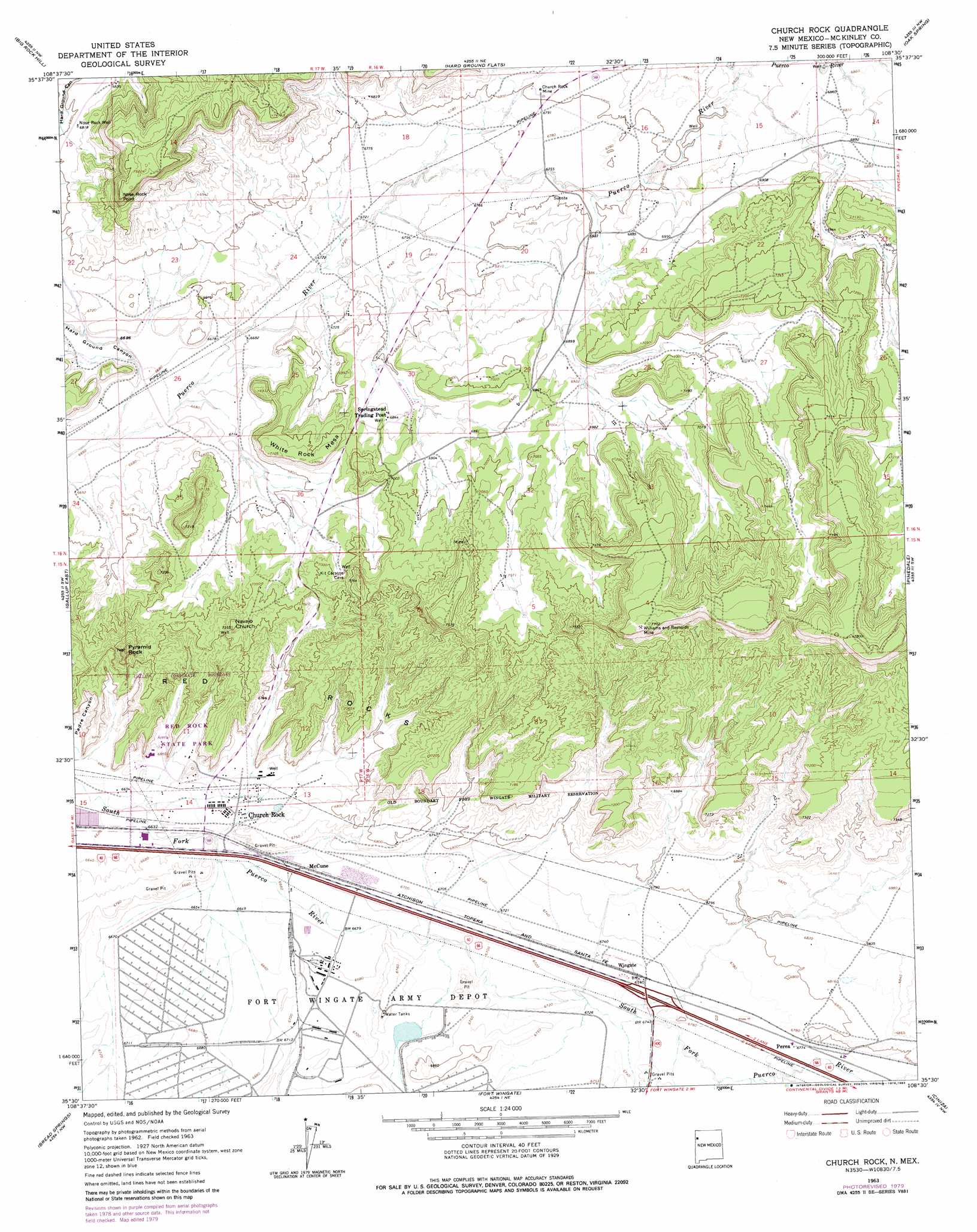
Church Rock Topo Map New Mexico
To zoom in, hover over the map of Church Rock
USGS Topo Quad 35108e5 - 1:24,000 scale
| Topo Map Name: | Church Rock |
| USGS Topo Quad ID: | 35108e5 |
| Print Size: | ca. 21 1/4" wide x 27" high |
| Southeast Coordinates: | 35.5° N latitude / 108.5° W longitude |
| Map Center Coordinates: | 35.5625° N latitude / 108.5625° W longitude |
| U.S. State: | NM |
| Filename: | o35108e5.jpg |
| Download Map JPG Image: | Church Rock topo map 1:24,000 scale |
| Map Type: | Topographic |
| Topo Series: | 7.5´ |
| Map Scale: | 1:24,000 |
| Source of Map Images: | United States Geological Survey (USGS) |
| Alternate Map Versions: |
Church Rock NM 1963, updated 1967 Download PDF Buy paper map Church Rock NM 1963, updated 1979 Download PDF Buy paper map Church Rock NM 1963, updated 1983 Download PDF Buy paper map Church Rock NM 2010 Download PDF Buy paper map Church Rock NM 2013 Download PDF Buy paper map |
1:24,000 Topo Quads surrounding Church Rock
Tohatchi |
Chuska Lake |
Coyote Canyon |
Toyee |
Standing Rock |
Twin Lakes |
Big Rock Hill |
Hard Ground Flats |
Oak Spring |
Dalton Pass |
Gallup West |
Gallup East |
Church Rock |
Pinedale |
Mariano Lake |
Twin Buttes |
Bread Springs |
Fort Wingate |
Ciniza |
Continental Divide |
Vander Wagen |
Pinehaven |
Upper Nutria |
Page |
Cottonwood Canyon |
> Back to 35108e1 at 1:100,000 scale
> Back to 35108a1 at 1:250,000 scale
> Back to U.S. Topo Maps home
Church Rock topo map: Gazetteer
Church Rock: Capes
Nose Rock Point elevation 2238m 7342′Church Rock: Mines
Church Rock Mine elevation 2076m 6811′Foutz Number 1 Mine elevation 2207m 7240′
Foutz Number 2 elevation 2178m 7145′
Foutz Number Three Mine elevation 2213m 7260′
U Mine elevation 2307m 7568′
Williams and Reynolds Mine elevation 2342m 7683′
Church Rock: Parks
Red Rock State Park elevation 2049m 6722′Red Rocks Historical Marker elevation 2121m 6958′
Church Rock: Pillars
Navajo Church elevation 2212m 7257′Pyramid Rock elevation 2277m 7470′
Church Rock: Populated Places
Church Rock elevation 2038m 6686′McCune elevation 2036m 6679′
Navajo Wingate Village elevation 2129m 6984′
Perea elevation 2066m 6778′
Wingate elevation 2055m 6742′
Church Rock: Post Offices
Church Rock Post Office elevation 2038m 6686′Church Rock: Slopes
Red Rocks elevation 2121m 6958′Church Rock: Springs
Kit Carson Spring elevation 2163m 7096′Church Rock: Summits
White Rock Mesa elevation 2157m 7076′Church Rock: Valleys
Hard Ground Canyon elevation 2031m 6663′Church Rock: Wells
10022 Water Well elevation 2096m 6876′16T-510 Water Well elevation 2083m 6833′
16T-513 Water Well elevation 2096m 6876′
Fort Wingate 68 Water Well elevation 2037m 6683′
Nose Rock Well elevation 2081m 6827′
SJOBS Water Well elevation 2037m 6683′
Wingate 6 Water Well elevation 2055m 6742′
Wingate 7 Water Well elevation 2057m 6748′
Church Rock digital topo map on disk
Buy this Church Rock topo map showing relief, roads, GPS coordinates and other geographical features, as a high-resolution digital map file on DVD: