Dean Peak Topo Map Arizona
To zoom in, hover over the map of Dean Peak
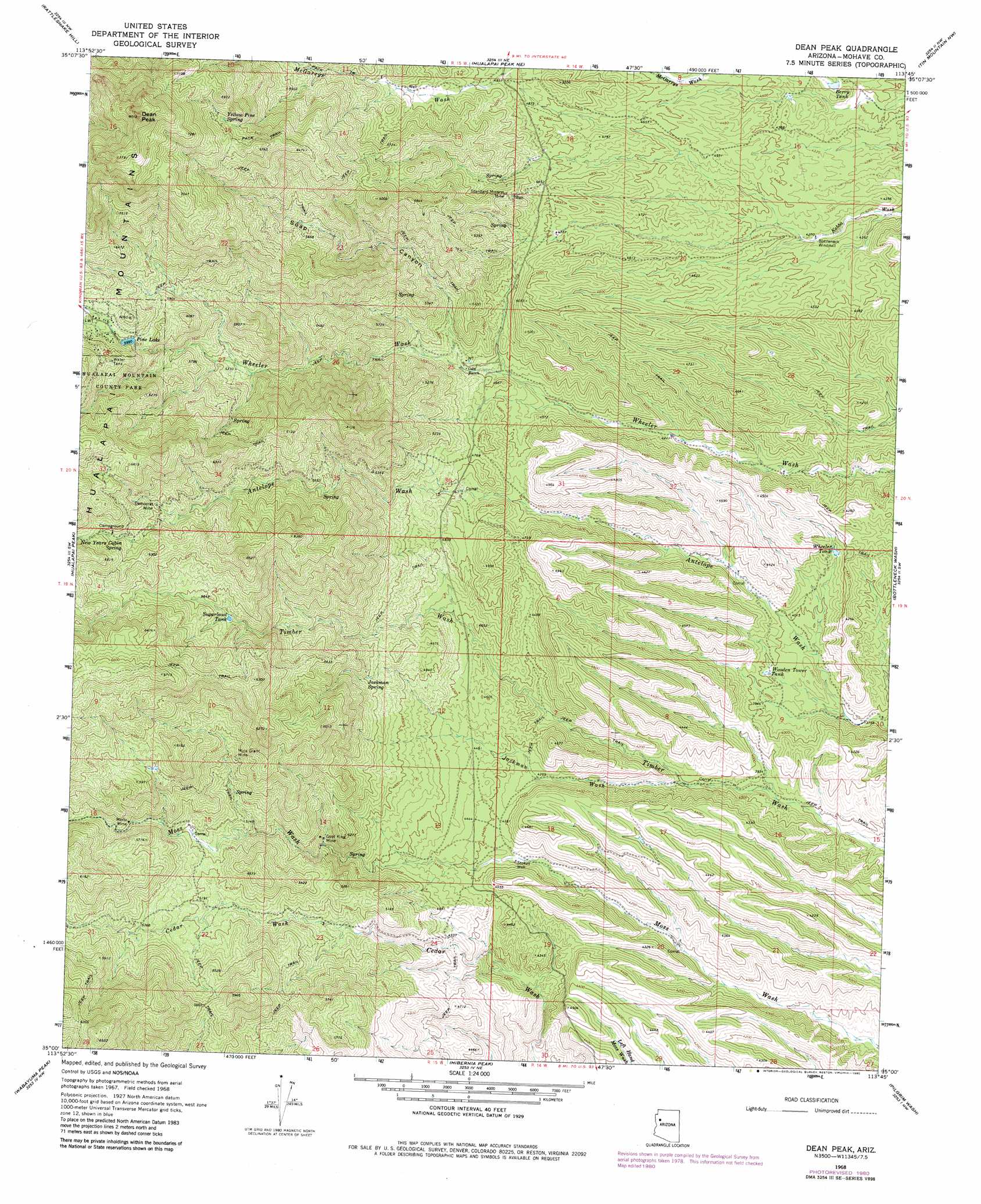
USGS Topo Quad 35113a7 - 1:24,000 scale
| Topo Map Name: | Dean Peak |
| USGS Topo Quad ID: | 35113a7 |
| Print Size: | ca. 21 1/4" wide x 27" high |
| Southeast Coordinates: | 35° N latitude / 113.75° W longitude |
| Map Center Coordinates: | 35.0625° N latitude / 113.8125° W longitude |
| U.S. State: | AZ |
| Filename: | o35113a7.jpg |
| Download Map JPG Image: | Dean Peak topo map 1:24,000 scale |
| Map Type: | Topographic |
| Topo Series: | 7.5´ |
| Map Scale: | 1:24,000 |
| Source of Map Images: | United States Geological Survey (USGS) |
| Alternate Map Versions: |
Dean Peak AZ 1968, updated 1971 Download PDF Buy paper map Dean Peak AZ 1968, updated 1972 Download PDF Buy paper map Dean Peak AZ 1968, updated 1980 Download PDF Buy paper map Dean Peak AZ 2011 Download PDF Buy paper map Dean Peak AZ 2014 Download PDF Buy paper map |
1:24,000 Topo Quads surrounding Dean Peak
Stockton Hill |
Kingman Airport |
Peacock Peak |
Hackberry |
Valentine Se |
Kingman |
Rattlesnake Hill |
Hualapai Spring |
Tin Mountain Nw |
Tin Mountain |
Kingman Se |
Hualapai Peak |
Dean Peak |
Bottleneck Wash |
Austin Peak |
Yucca Ne |
Wabayuma Peak |
Hibernia Peak |
Pilgrim Wash |
Tom Brown Canyon |
Yucca Se |
Creamery Canyon |
Diamond Joe Peak |
Gunsight Canyon |
Tule Wash |
> Back to 35113a1 at 1:100,000 scale
> Back to 35112a1 at 1:250,000 scale
> Back to U.S. Topo Maps home
Dean Peak topo map: Gazetteer
Dean Peak: Lakes
Pine Lake elevation 1824m 5984′Dean Peak: Mines
Democrat Mine elevation 1819m 5967′Gold King Mine elevation 1484m 4868′
Merlo Mine elevation 1649m 5410′
Mica Giant Mine elevation 1674m 5492′
Standard Mineral Mine elevation 1594m 5229′
Dean Peak: Reservoirs
Berry Tank elevation 1304m 4278′Sugarbowl Tank elevation 1724m 5656′
Wheeler Tank elevation 1252m 4107′
Wooden Tower Tank elevation 1218m 3996′
Dean Peak: Springs
Jackman Spring elevation 1533m 5029′New Years Cabin Spring elevation 1857m 6092′
Yellow Pine Spring elevation 1994m 6541′
Dean Peak: Streams
Jackman Wash elevation 1220m 4002′Dean Peak: Summits
Dean Peak elevation 2420m 7939′Dean Peak: Valleys
Soap Canyon elevation 1420m 4658′Dean Peak: Wells
Stokes Well elevation 1313m 4307′Dean Peak digital topo map on disk
Buy this Dean Peak topo map showing relief, roads, GPS coordinates and other geographical features, as a high-resolution digital map file on DVD: