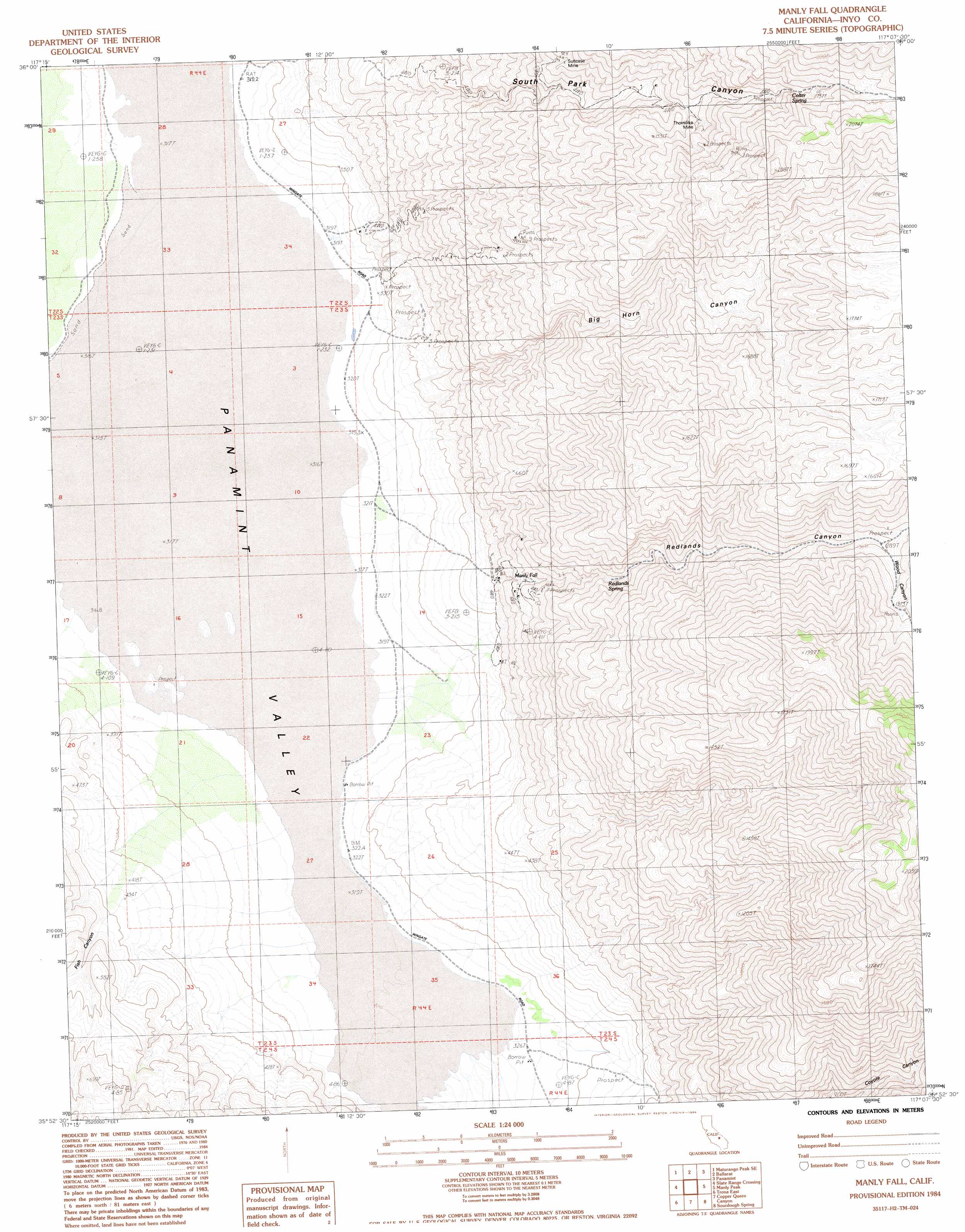
Manly Fall Topo Map California
To zoom in, hover over the map of Manly Fall
USGS Topo Quad 35117h2 - 1:24,000 scale
| Topo Map Name: | Manly Fall |
| USGS Topo Quad ID: | 35117h2 |
| Print Size: | ca. 21 1/4" wide x 27" high |
| Southeast Coordinates: | 35.875° N latitude / 117.125° W longitude |
| Map Center Coordinates: | 35.9375° N latitude / 117.1875° W longitude |
| U.S. State: | CA |
| Filename: | o35117h2.jpg |
| Download Map JPG Image: | Manly Fall topo map 1:24,000 scale |
| Map Type: | Topographic |
| Topo Series: | 7.5´ |
| Map Scale: | 1:24,000 |
| Source of Map Images: | United States Geological Survey (USGS) |
| Alternate Map Versions: |
Manly Fall CA 1984, updated 1984 Download PDF Buy paper map Manly Fall CA 2012 Download PDF Buy paper map Manly Fall CA 2015 Download PDF Buy paper map |
1:24,000 Topo Quads surrounding Manly Fall
Revenue Canyon |
Maturango Peak Ne |
Jail Canyon |
Telescope Peak |
Hanaupah Canyon |
Maturango Peak |
Maturango Peak Se |
Ballarat |
Panamint |
Galena Canyon |
Homewood Canyon |
Slate Range Crossing |
Manly Fall |
Manly Peak |
Anvil Spring Canyon West |
Trona West |
Trona East |
Copper Queen Canyon |
Sourdough Spring |
Wingate Wash West |
Westend |
Searles Lake |
Layton Spring |
Wingate Pass |
Hidden Spring |
> Back to 35117e1 at 1:100,000 scale
> Back to 35116a1 at 1:250,000 scale
> Back to U.S. Topo Maps home
Manly Fall topo map: Gazetteer
Manly Fall: Falls
Manly Fall elevation 466m 1528′Manly Fall: Mines
Suitcase Mine elevation 1234m 4048′Thorndike Mine elevation 1449m 4753′
Manly Fall: Springs
Colter Spring elevation 1713m 5620′Redlands Spring elevation 775m 2542′
Manly Fall: Valleys
Big Horn Canyon elevation 396m 1299′Fish Canyon elevation 446m 1463′
Redlands Canyon elevation 468m 1535′
South Park Canyon elevation 365m 1197′
Wood Canyon elevation 1296m 4251′
Manly Fall digital topo map on disk
Buy this Manly Fall topo map showing relief, roads, GPS coordinates and other geographical features, as a high-resolution digital map file on DVD:
Southern Sierra Nevada, California & Southern Nevada
Buy digital topo maps: Southern Sierra Nevada, California & Southern Nevada