Revenue Canyon Topo Map California
To zoom in, hover over the map of Revenue Canyon
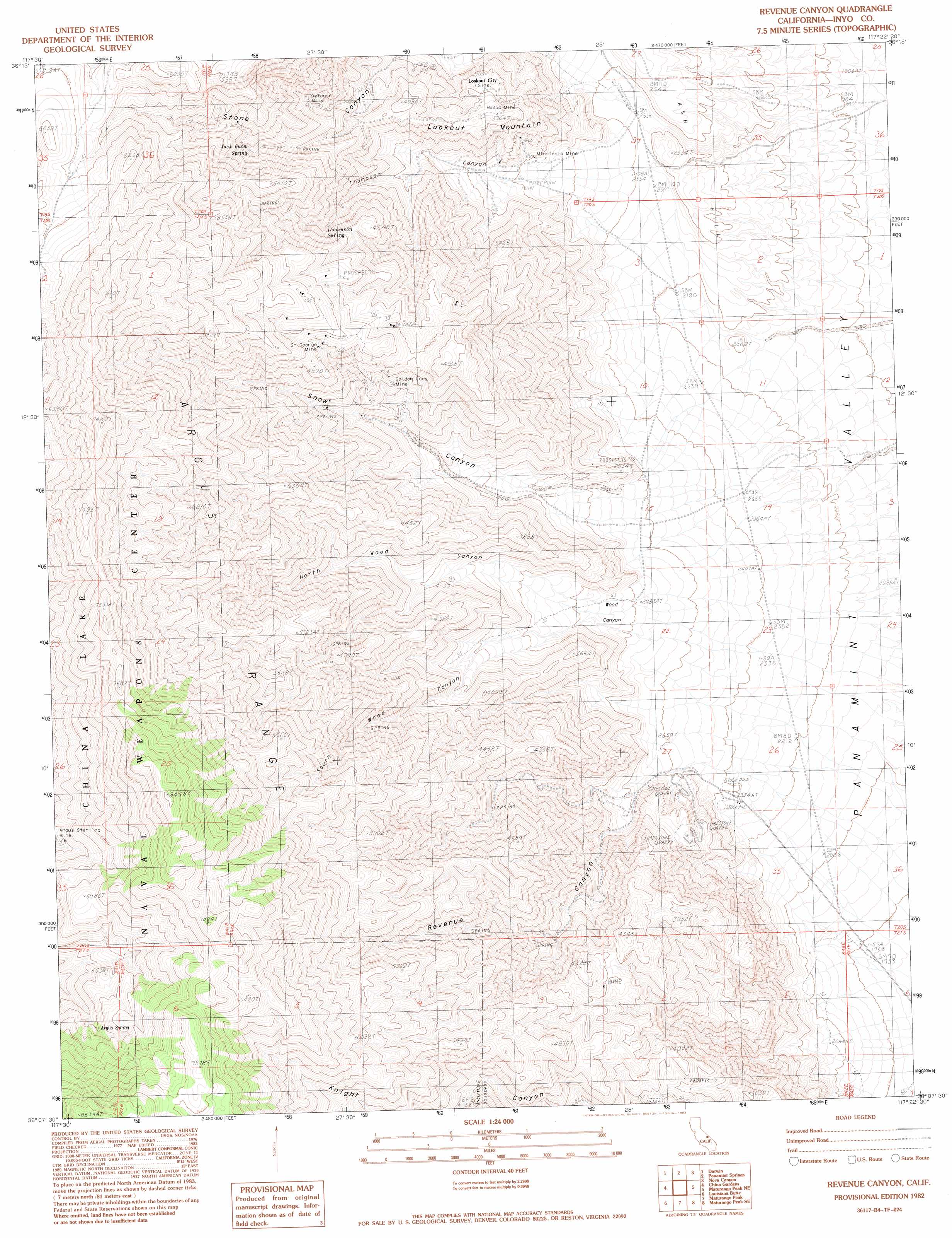
USGS Topo Quad 36117b4 - 1:24,000 scale
| Topo Map Name: | Revenue Canyon |
| USGS Topo Quad ID: | 36117b4 |
| Print Size: | ca. 21 1/4" wide x 27" high |
| Southeast Coordinates: | 36.125° N latitude / 117.375° W longitude |
| Map Center Coordinates: | 36.1875° N latitude / 117.4375° W longitude |
| U.S. State: | CA |
| Filename: | o36117b4.jpg |
| Download Map JPG Image: | Revenue Canyon topo map 1:24,000 scale |
| Map Type: | Topographic |
| Topo Series: | 7.5´ |
| Map Scale: | 1:24,000 |
| Source of Map Images: | United States Geological Survey (USGS) |
| Alternate Map Versions: |
Revenue Canyon CA 1982, updated 1983 Download PDF Buy paper map Revenue Canyon CA 1982, updated 1983 Download PDF Buy paper map Revenue Canyon CA 2012 Download PDF Buy paper map Revenue Canyon CA 2015 Download PDF Buy paper map |
1:24,000 Topo Quads surrounding Revenue Canyon
Santa Rosa Flat |
Lee Wash |
The Dunes |
Panamint Butte |
Emigrant Canyon |
Talc City Hills |
Darwin |
Panamint Springs |
Nova Canyon |
Emigrant Pass |
Coso Peak |
China Gardens |
Revenue Canyon |
Maturango Peak Ne |
Jail Canyon |
Petroglyph Canyon |
Louisiana Butte |
Maturango Peak |
Maturango Peak Se |
Ballarat |
Airport Lake |
Mountain Springs Canyon |
Homewood Canyon |
Slate Range Crossing |
Manly Fall |
> Back to 36117a1 at 1:100,000 scale
> Back to 36116a1 at 1:250,000 scale
> Back to U.S. Topo Maps home
Revenue Canyon topo map: Gazetteer
Revenue Canyon: Mines
Argus Sterling Mine elevation 1913m 6276′Cowshed Workings elevation 943m 3093′
Defense Mine elevation 1279m 4196′
Golden Lady Mine elevation 1218m 3996′
Little Mack Mine elevation 808m 2650′
Minnietta Mine elevation 898m 2946′
Modoc Mine elevation 833m 2732′
Saint George Mines elevation 1433m 4701′
Revenue Canyon: Populated Places
Lookout City (historical) elevation 1091m 3579′Revenue Canyon: Springs
Argus Spring elevation 1946m 6384′French Madam Spring elevation 1677m 5501′
Jack Gunn Spring elevation 1366m 4481′
Thompson Spring elevation 1240m 4068′
Revenue Canyon: Summits
Lookout Mountain elevation 1240m 4068′Revenue Canyon: Trails
Nadeau Trail elevation 683m 2240′Revenue Canyon: Valleys
North Wood Canyon elevation 912m 2992′Revenue Canyon elevation 822m 2696′
Snow Canyon elevation 804m 2637′
South Wood Canyon elevation 914m 2998′
Thompson Canyon elevation 759m 2490′
Wood Canyon elevation 852m 2795′
Revenue Canyon digital topo map on disk
Buy this Revenue Canyon topo map showing relief, roads, GPS coordinates and other geographical features, as a high-resolution digital map file on DVD:
Southern Sierra Nevada, California & Southern Nevada
Buy digital topo maps: Southern Sierra Nevada, California & Southern Nevada