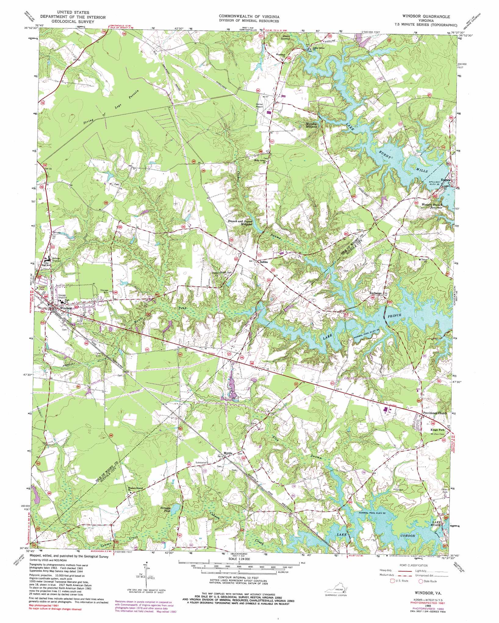
Windsor Topo Map Virginia
To zoom in, hover over the map of Windsor
USGS Topo Quad 36076g6 - 1:24,000 scale
| Topo Map Name: | Windsor |
| USGS Topo Quad ID: | 36076g6 |
| Print Size: | ca. 21 1/4" wide x 27" high |
| Southeast Coordinates: | 36.75° N latitude / 76.625° W longitude |
| Map Center Coordinates: | 36.8125° N latitude / 76.6875° W longitude |
| U.S. State: | VA |
| Filename: | o36076g6.jpg |
| Download Map JPG Image: | Windsor topo map 1:24,000 scale |
| Map Type: | Topographic |
| Topo Series: | 7.5´ |
| Map Scale: | 1:24,000 |
| Source of Map Images: | United States Geological Survey (USGS) |
| Alternate Map Versions: |
Windsor VA 1944, updated 1961 Download PDF Buy paper map Windsor VA 1965, updated 1966 Download PDF Buy paper map Windsor VA 1965, updated 1973 Download PDF Buy paper map Windsor VA 1965, updated 1980 Download PDF Buy paper map Windsor VA 1965, updated 1985 Download PDF Buy paper map Windsor VA 1965, updated 1985 Download PDF Buy paper map Windsor VA 2011 Download PDF Buy paper map Windsor VA 2013 Download PDF Buy paper map Windsor VA 2016 Download PDF Buy paper map |
1:24,000 Topo Quads surrounding Windsor
Dendron |
Runnymede |
Bacons Castle |
Mulberry Island |
Newport News North |
Ivor |
Raynor |
Smithfield |
Benns Church |
Newport News South |
Sedley |
Zuni |
Windsor |
Chuckatuck |
Bowers Hill |
Franklin |
Holland |
Buckhorn |
Suffolk |
Lake Drummond Nw |
Riverdale |
Gates |
Whaleyville |
Corapeake |
Lake Drummond |
> Back to 36076e1 at 1:100,000 scale
> Back to 36076a1 at 1:250,000 scale
> Back to U.S. Topo Maps home
Windsor topo map: Gazetteer
Windsor: Airports
Garner Airport elevation 24m 78′Windsor: Dams
Lake Burnt Mills Dam elevation 7m 22′Lake Cohoon Dam elevation 8m 26′
Lake Rhodes Dam elevation 14m 45′
Windsor: Populated Places
Acorn Acres elevation 21m 68′Everets elevation 9m 29′
Idlewood elevation 18m 59′
Indika elevation 22m 72′
Lake Prince Farms elevation 16m 52′
Lake Prince Meadows elevation 19m 62′
Myrtle elevation 21m 68′
Providence Church elevation 23m 75′
Twin Ponds Mobile Home Park elevation 24m 78′
Windsor elevation 24m 78′
Windsor Manor Mobile Home Park elevation 24m 78′
Windsor: Post Offices
Windsor Post Office elevation 24m 78′Windsor: Reservoirs
Branch and Joyner Millpond elevation 10m 32′Lake Burnt Mills elevation 7m 22′
Lake Burnt Mills elevation 9m 29′
Lake Cohoon elevation 6m 19′
Lake Rhodes elevation 14m 45′
Murphys Millpond elevation 9m 29′
Prudens Millpond elevation 9m 29′
Scruggs Pond elevation 12m 39′
Windsor: Streams
Carbell Swamp elevation 6m 19′Cohoon Creek elevation 8m 26′
Great Swamp elevation 11m 36′
Windsor: Swamps
Eley Swamp elevation 10m 32′Ennis Pond elevation 10m 32′
String of Logs Pocosin elevation 25m 82′
Windsor digital topo map on disk
Buy this Windsor topo map showing relief, roads, GPS coordinates and other geographical features, as a high-resolution digital map file on DVD:
Atlantic Coast (NY, NJ, PA, DE, MD, VA, NC)
Buy digital topo maps: Atlantic Coast (NY, NJ, PA, DE, MD, VA, NC)
 map DVD")