Buckhorn Topo Map Virginia
To zoom in, hover over the map of Buckhorn
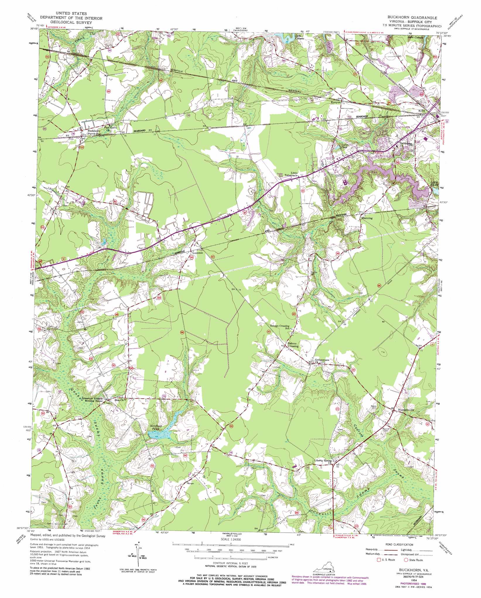
USGS Topo Quad 36076f6 - 1:24,000 scale
| Topo Map Name: | Buckhorn |
| USGS Topo Quad ID: | 36076f6 |
| Print Size: | ca. 21 1/4" wide x 27" high |
| Southeast Coordinates: | 36.625° N latitude / 76.625° W longitude |
| Map Center Coordinates: | 36.6875° N latitude / 76.6875° W longitude |
| U.S. State: | VA |
| Filename: | o36076f6.jpg |
| Download Map JPG Image: | Buckhorn topo map 1:24,000 scale |
| Map Type: | Topographic |
| Topo Series: | 7.5´ |
| Map Scale: | 1:24,000 |
| Source of Map Images: | United States Geological Survey (USGS) |
| Alternate Map Versions: |
Buckhorn VA 1954, updated 1955 Download PDF Buy paper map Buckhorn VA 1954, updated 1964 Download PDF Buy paper map Buckhorn VA 1954, updated 1969 Download PDF Buy paper map Buckhorn VA 1954, updated 1980 Download PDF Buy paper map Buckhorn VA 1954, updated 1986 Download PDF Buy paper map Buckhorn VA 1954, updated 1986 Download PDF Buy paper map Buckhorn VA 2011 Download PDF Buy paper map Buckhorn VA 2013 Download PDF Buy paper map Buckhorn VA 2016 Download PDF Buy paper map |
1:24,000 Topo Quads surrounding Buckhorn
Ivor |
Raynor |
Smithfield |
Benns Church |
Newport News South |
Sedley |
Zuni |
Windsor |
Chuckatuck |
Bowers Hill |
Franklin |
Holland |
Buckhorn |
Suffolk |
Lake Drummond Nw |
Riverdale |
Gates |
Whaleyville |
Corapeake |
Lake Drummond |
Winton |
Gatesville |
Merchants Millpond |
Sunbury |
Lynchs Corner |
> Back to 36076e1 at 1:100,000 scale
> Back to 36076a1 at 1:250,000 scale
> Back to U.S. Topo Maps home
Buckhorn topo map: Gazetteer
Buckhorn: Airports
Grasso Salvage Airport elevation 20m 65′Buckhorn: Dams
Norfleet Dam elevation 13m 42′Speights Run Dam elevation 7m 22′
Buckhorn: Populated Places
Bakers Crossing elevation 21m 68′Barrett Acres elevation 20m 65′
Bethlehem Court elevation 18m 59′
Bethlehem Terrace elevation 15m 49′
Box Elder elevation 16m 52′
Forest Glen Terrace elevation 20m 65′
Hillsdale elevation 22m 72′
Kenyon elevation 22m 72′
Kilby elevation 21m 68′
Lake Speight Colony elevation 16m 52′
Lakewood elevation 13m 42′
Leesville elevation 22m 72′
Lummis elevation 22m 72′
Lutersville elevation 21m 68′
Manning elevation 21m 68′
Maple Hill elevation 20m 65′
Nurneysville elevation 20m 65′
Oak Ridge elevation 18m 59′
Oak Ridge East elevation 21m 68′
Oak Ridge Estates elevation 15m 49′
Pinaire elevation 13m 42′
Westgate elevation 16m 52′
Buckhorn: Reservoirs
Copeland Pond (historical) elevation 16m 52′Luter Pond elevation 13m 42′
Norfleet Pond elevation 13m 42′
Speights Run Reservoir elevation 7m 22′
Buckhorn: Streams
Council Swamp elevation 11m 36′Speights Run elevation 7m 22′
Buckhorn: Swamps
Daughtrey Pocoson elevation 15m 49′Quaker Swamp elevation 11m 36′
Buckhorn digital topo map on disk
Buy this Buckhorn topo map showing relief, roads, GPS coordinates and other geographical features, as a high-resolution digital map file on DVD:
Atlantic Coast (NY, NJ, PA, DE, MD, VA, NC)
Buy digital topo maps: Atlantic Coast (NY, NJ, PA, DE, MD, VA, NC)
 map DVD")