Wytheville Topo Map Virginia
To zoom in, hover over the map of Wytheville
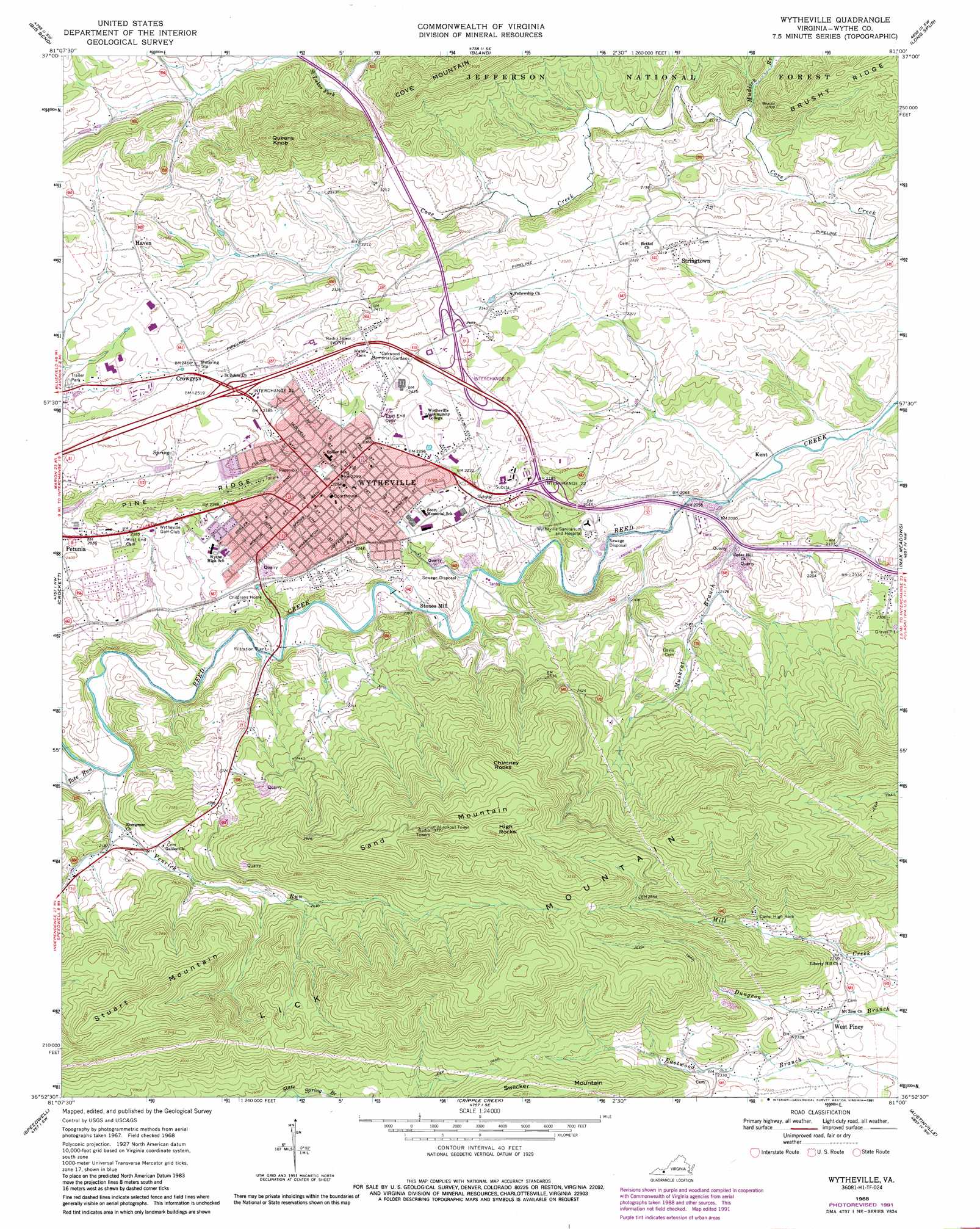
USGS Topo Quad 36081h1 - 1:24,000 scale
| Topo Map Name: | Wytheville |
| USGS Topo Quad ID: | 36081h1 |
| Print Size: | ca. 21 1/4" wide x 27" high |
| Southeast Coordinates: | 36.875° N latitude / 81° W longitude |
| Map Center Coordinates: | 36.9375° N latitude / 81.0625° W longitude |
| U.S. State: | VA |
| Filename: | o36081h1.jpg |
| Download Map JPG Image: | Wytheville topo map 1:24,000 scale |
| Map Type: | Topographic |
| Topo Series: | 7.5´ |
| Map Scale: | 1:24,000 |
| Source of Map Images: | United States Geological Survey (USGS) |
| Alternate Map Versions: |
Wytheville VA 1968, updated 1970 Download PDF Buy paper map Wytheville VA 1968, updated 1978 Download PDF Buy paper map Wytheville VA 1968, updated 1991 Download PDF Buy paper map Wytheville VA 1968, updated 1991 Download PDF Buy paper map Wytheville VA 1976, updated 1983 Download PDF Buy paper map Wytheville VA 2011 Download PDF Buy paper map Wytheville VA 2013 Download PDF Buy paper map Wytheville VA 2016 Download PDF Buy paper map |
| FStopo: | US Forest Service topo Wytheville is available: Download FStopo PDF Download FStopo TIF |
1:24,000 Topo Quads surrounding Wytheville
Cove Creek |
Bastian |
Rocky Gap |
Mechanicsburg |
White Gate |
Garden Mountain |
Big Bend |
Bland |
Long Spur |
Pulaski |
Rural Retreat |
Crockett |
Wytheville |
Max Meadows |
Fosters Falls |
Cedar Springs |
Speedwell |
Cripple Creek |
Austinville |
Sylvatus |
Middle Fox Creek |
Elk Creek |
Brierpatch Mountain |
Galax |
Woodlawn |
> Back to 36081e1 at 1:100,000 scale
> Back to 36080a1 at 1:250,000 scale
> Back to U.S. Topo Maps home
Wytheville topo map: Gazetteer
Wytheville: Airports
Wythe County Community Hospital Heliport elevation 700m 2296′Wytheville: Crossings
Interchange 40 elevation 711m 2332′Interchange 41 elevation 718m 2355′
Interchange 70 elevation 743m 2437′
Interchange 72 elevation 711m 2332′
Interchange 73 elevation 658m 2158′
Interchange 77 elevation 680m 2230′
Wytheville: Populated Places
Crowgeys elevation 755m 2477′Kent elevation 618m 2027′
Kindrick elevation 707m 2319′
Petunia elevation 712m 2335′
Stones Mill elevation 635m 2083′
Stringtown elevation 708m 2322′
West Piney elevation 696m 2283′
Wytheville elevation 697m 2286′
Wytheville: Post Offices
Wytheville Post Office elevation 698m 2290′Wytheville: Streams
Mudlick Branch elevation 641m 2103′Muskrat Branch elevation 621m 2037′
Saint Lukes Fork elevation 674m 2211′
Tate Run elevation 642m 2106′
Venrick Run elevation 643m 2109′
Wytheville: Summits
Chimney Rocks elevation 1015m 3330′High Rocks elevation 1111m 3645′
Lick Mountain elevation 1073m 3520′
Queens Knob elevation 964m 3162′
Sand Mountain elevation 1123m 3684′
Stuart Mountain elevation 993m 3257′
Swecker Mountain elevation 912m 2992′
Wytheville digital topo map on disk
Buy this Wytheville topo map showing relief, roads, GPS coordinates and other geographical features, as a high-resolution digital map file on DVD:
Western Virginia & Southern West Virginia
Buy digital topo maps: Western Virginia & Southern West Virginia