Middle Fox Creek Topo Map Virginia
To zoom in, hover over the map of Middle Fox Creek
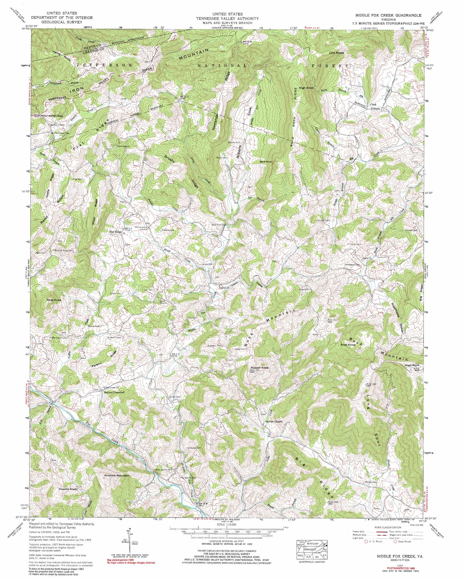
USGS Topo Quad 36081f3 - 1:24,000 scale
| Topo Map Name: | Middle Fox Creek |
| USGS Topo Quad ID: | 36081f3 |
| Print Size: | ca. 21 1/4" wide x 27" high |
| Southeast Coordinates: | 36.625° N latitude / 81.25° W longitude |
| Map Center Coordinates: | 36.6875° N latitude / 81.3125° W longitude |
| U.S. State: | VA |
| Filename: | o36081f3.jpg |
| Download Map JPG Image: | Middle Fox Creek topo map 1:24,000 scale |
| Map Type: | Topographic |
| Topo Series: | 7.5´ |
| Map Scale: | 1:24,000 |
| Source of Map Images: | United States Geological Survey (USGS) |
| Alternate Map Versions: |
Middle Fox Creek VA 1935 Download PDF Buy paper map Middle Fox Creek VA 1959, updated 1960 Download PDF Buy paper map Middle Fox Creek VA 1959, updated 1960 Download PDF Buy paper map Middle Fox Creek VA 1959, updated 1974 Download PDF Buy paper map Middle Fox Creek VA 1959, updated 1991 Download PDF Buy paper map Middle Fox Creek VA 2011 Download PDF Buy paper map Middle Fox Creek VA 2013 Download PDF Buy paper map Middle Fox Creek VA 2016 Download PDF Buy paper map |
| FStopo: | US Forest Service topo Middle Fox Creek is available: Download FStopo PDF Download FStopo TIF |
1:24,000 Topo Quads surrounding Middle Fox Creek
Chatham Hill |
Nebo |
Rural Retreat |
Crockett |
Wytheville |
Marion |
Atkins |
Cedar Springs |
Speedwell |
Cripple Creek |
Whitetop Mountain |
Trout Dale |
Middle Fox Creek |
Elk Creek |
Brierpatch Mountain |
Park |
Grassy Creek |
Mouth Of Wilson |
Sparta West |
Sparta East |
Warrensville |
Jefferson |
Laurel Springs |
Whitehead |
Glade Valley |
> Back to 36081e1 at 1:100,000 scale
> Back to 36080a1 at 1:250,000 scale
> Back to U.S. Topo Maps home
Middle Fox Creek topo map: Gazetteer
Middle Fox Creek: Flats
Hemp Patch elevation 1186m 3891′Middle Fox Creek: Gaps
Blue Spring Gap elevation 1211m 3973′Flat Ridge Gap elevation 1117m 3664′
Houndshell Gap elevation 1122m 3681′
Middle Fox Creek: Populated Places
Barton Crossroad elevation 816m 2677′Flat Ridge elevation 890m 2919′
Middle Fox Creek: Ridges
Bald Rock Ridge elevation 1182m 3877′Big Ridge elevation 941m 3087′
Brushy Ridge elevation 1113m 3651′
Brushy Spur elevation 1185m 3887′
Cinnamon Ridge elevation 966m 3169′
Flat Ridge elevation 1185m 3887′
Long Spur elevation 1211m 3973′
Mikes Ridge elevation 1110m 3641′
Nettle Ridge elevation 1184m 3884′
Newlands Ridge elevation 1166m 3825′
Perkins Ridge elevation 953m 3126′
Razor Ridge elevation 1249m 4097′
Middle Fox Creek: Streams
Carico Branch elevation 892m 2926′Clems Branch elevation 831m 2726′
Fall Branch elevation 776m 2545′
Goose Creek elevation 869m 2851′
Guffey Creek elevation 775m 2542′
Jerry Creek elevation 868m 2847′
Lee Branch elevation 871m 2857′
Middle Branch Elk Creek elevation 892m 2926′
Middle Fox Creek elevation 750m 2460′
Nettle Branch elevation 1058m 3471′
North Branch Elk Creek elevation 840m 2755′
Panther Creek elevation 848m 2782′
Shupe Creek elevation 838m 2749′
Young Branch elevation 752m 2467′
Middle Fox Creek: Summits
Bald Rock elevation 1188m 3897′Buck Mountain elevation 1417m 4648′
Buck Mountain elevation 1120m 3674′
Couchs Knob elevation 1088m 3569′
Fries Knob elevation 1234m 4048′
High Knob elevation 1266m 4153′
High Rock elevation 1418m 4652′
Kindrick Mountain elevation 1159m 3802′
Lina Rocks elevation 1163m 3815′
Roaring Hill elevation 977m 3205′
Ross Knob elevation 1126m 3694′
Russell Knob elevation 1096m 3595′
Middle Fox Creek: Valleys
Logan Hollow elevation 969m 3179′Roberts Cove elevation 878m 2880′
Rye Cove elevation 864m 2834′
Sugarcamp Hollow elevation 969m 3179′
Middle Fox Creek digital topo map on disk
Buy this Middle Fox Creek topo map showing relief, roads, GPS coordinates and other geographical features, as a high-resolution digital map file on DVD:
Western Virginia & Southern West Virginia
Buy digital topo maps: Western Virginia & Southern West Virginia