Nashville West Topo Map Tennessee
To zoom in, hover over the map of Nashville West
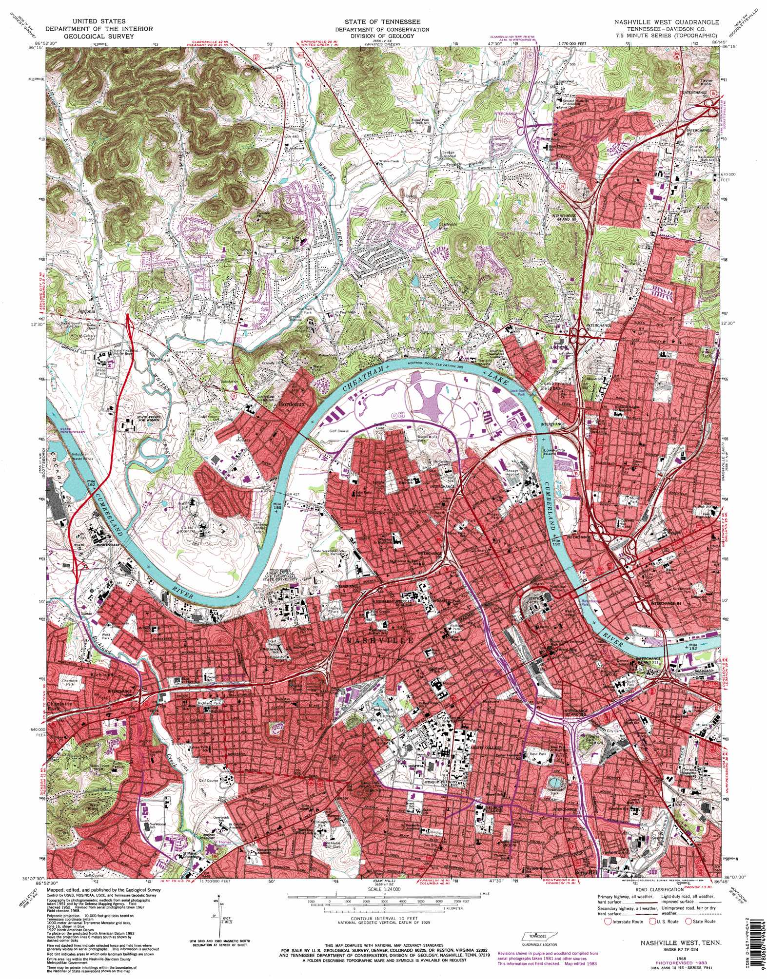
USGS Topo Quad 36086b7 - 1:24,000 scale
| Topo Map Name: | Nashville West |
| USGS Topo Quad ID: | 36086b7 |
| Print Size: | ca. 21 1/4" wide x 27" high |
| Southeast Coordinates: | 36.125° N latitude / 86.75° W longitude |
| Map Center Coordinates: | 36.1875° N latitude / 86.8125° W longitude |
| U.S. State: | TN |
| Filename: | o36086b7.jpg |
| Download Map JPG Image: | Nashville West topo map 1:24,000 scale |
| Map Type: | Topographic |
| Topo Series: | 7.5´ |
| Map Scale: | 1:24,000 |
| Source of Map Images: | United States Geological Survey (USGS) |
| Alternate Map Versions: |
Nashville West TN 1952, updated 1954 Download PDF Buy paper map Nashville West TN 1952, updated 1964 Download PDF Buy paper map Nashville West TN 1968, updated 1971 Download PDF Buy paper map Nashville West TN 1968, updated 1980 Download PDF Buy paper map Nashville West TN 1968, updated 1984 Download PDF Buy paper map Nashville West TN 1968, updated 1984 Download PDF Buy paper map Nashville West TN 1997, updated 1999 Download PDF Buy paper map Nashville West TN 2010 Download PDF Buy paper map Nashville West TN 2013 Download PDF Buy paper map Nashville West TN 2016 Download PDF Buy paper map |
1:24,000 Topo Quads surrounding Nashville West
Pleasant View |
Springfield South |
Greenbrier |
White House |
Cottontown |
Ashland City |
Forest Grove |
Whites Creek |
Goodlettsville |
Hendersonville |
Lillamay |
Scottsboro |
Nashville West |
Nashville East |
Hermitage |
Kingston Springs |
Bellevue |
Oak Hill |
Antioch |
La Vergne |
Fairview |
Leipers Fork |
Franklin |
Nolensville |
Smyrna |
> Back to 36086a1 at 1:100,000 scale
> Back to 36086a1 at 1:250,000 scale
> Back to U.S. Topo Maps home
Nashville West topo map: Gazetteer
Nashville West: Airports
Clinical Laboratories Airport elevation 162m 531′Saint Thomas Hospital Airport elevation 165m 541′
Nashville West: Bends
Hardins Bend elevation 125m 410′Nashville West: Bridges
Briley Parkway Bridge elevation 117m 383′Evans Memorial Bridge elevation 117m 383′
Hydes Ferry Bridge elevation 117m 383′
Jefferson Street Bridge elevation 117m 383′
Lyle A Fulton Bridge elevation 117m 383′
Sparkman Street Bridge elevation 117m 383′
Victory Memorial Bridge elevation 117m 383′
Woodland Street Bridge elevation 117m 383′
Nashville West: Crossings
Buena Vista Ferry (historical) elevation 117m 383′Hydes Ferry (historical) elevation 117m 383′
Interchange 1 elevation 143m 469′
Interchange 14 elevation 133m 436′
Interchange 15 elevation 136m 446′
Interchange 16 elevation 130m 426′
Interchange 16 elevation 197m 646′
Interchange 17 elevation 131m 429′
Interchange 18 elevation 139m 456′
Interchange 204 elevation 133m 436′
Interchange 205 elevation 150m 492′
Interchange 206 elevation 184m 603′
Interchange 207 elevation 137m 449′
Interchange 208 elevation 139m 456′
Interchange 209 elevation 143m 469′
Interchange 21 C elevation 152m 498′
Interchange 43 elevation 147m 482′
Interchange 44 and 88 elevation 170m 557′
Interchange 48 elevation 135m 442′
Interchange 57 elevation 141m 462′
Interchange 81 elevation 151m 495′
Interchange 82 and 210 elevation 156m 511′
Interchange 83 and 211 elevation 136m 446′
Interchange 84 elevation 130m 426′
Interchange 85 elevation 131m 429′
Interchange 86 elevation 129m 423′
Interchange 87 elevation 139m 456′
Interchange 89 elevation 185m 606′
Interchange 90 elevation 197m 646′
Nashville West: Dams
Eighth Avenue South Reservoir elevation 188m 616′Old Lock and Dam Number One (historical) elevation 117m 383′
Nashville West: Islands
Lower City Island elevation 119m 390′Nashville West: Lakes
Bush Lake elevation 125m 410′Nashville West: Parks
Alumni Lawn elevation 168m 551′Bicentennial Park elevation 145m 475′
Bordeaux Park elevation 136m 446′
Boyd Park elevation 134m 439′
Buena Vista Park elevation 127m 416′
Capers Field elevation 173m 567′
Centennial Park elevation 157m 515′
Chapman Quad elevation 166m 544′
Charlotte Park elevation 143m 469′
Cleveland Park elevation 137m 449′
Clifton Park elevation 144m 472′
Cumberland Park elevation 137m 449′
Curry Field elevation 158m 518′
Douglas Park elevation 129m 423′
Dudley Park elevation 136m 446′
East Park elevation 149m 488′
Edward S Temple Track elevation 125m 410′
Elizabeth Park elevation 143m 469′
Elmington Park elevation 167m 547′
Fort Negly Park elevation 178m 583′
Hadley Park elevation 146m 479′
Hartman Park elevation 125m 410′
Hawkins Field elevation 161m 528′
Howell Park elevation 144m 472′
Kirkpatrick Park elevation 153m 501′
Lock One Park elevation 131m 429′
LP Field elevation 125m 410′
Magnolia Lawn elevation 167m 547′
McCabe Park elevation 136m 446′
McFerrin Park elevation 138m 452′
Metro Riverfront Park elevation 125m 410′
Morgan Park elevation 132m 433′
Napier Park elevation 131m 429′
Parkwood Park elevation 159m 521′
Peabody Esplanade elevation 176m 577′
Reservoir Park elevation 199m 652′
Richland Park elevation 148m 485′
Rob Roy Purdy Field elevation 167m 547′
Rose Park elevation 191m 626′
Rucker Avenue Park elevation 201m 659′
South Park elevation 160m 524′
Ted Rhodes Park elevation 123m 403′
Trinity Hills Park elevation 165m 541′
Victory Park elevation 158m 518′
Watkins Park elevation 142m 465′
West Park elevation 126m 413′
Whitten Field elevation 189m 620′
William J Hale Stadium elevation 139m 456′
Nashville West: Populated Places
Avondale elevation 131m 429′Bordeaux elevation 151m 495′
Bordeaux Hills elevation 135m 442′
Brooklyn Heights elevation 146m 479′
Buena Vista Estates elevation 147m 482′
Cherokee Park elevation 153m 501′
Cumberland Heights elevation 147m 482′
East Nashville elevation 145m 475′
Jordonia elevation 130m 426′
Nashville elevation 170m 557′
Parkwood Estates elevation 158m 518′
Richland elevation 135m 442′
West Nashville elevation 144m 472′
Nashville West: Post Offices
Acklen Post Office elevation 173m 567′Church Street Post Office elevation 144m 472′
Fisk University Post Office elevation 152m 498′
Nashville Metropolitan Post Office elevation 124m 406′
Nashville Post Office elevation 148m 485′
Northeast Post Office elevation 150m 492′
West Nashville Post Office elevation 154m 505′
Nashville West: Reservoirs
Cantrells Lake elevation 158m 518′Shelbys Pond (historical) elevation 127m 416′
Nashville West: Springs
Sulphur Springs elevation 132m 433′Nashville West: Streams
Drake Branch elevation 123m 403′Dry Fork elevation 134m 439′
Eaton Creek elevation 119m 390′
Ewing Creek elevation 128m 419′
North Fork Ewing Creek elevation 142m 465′
Pages Branch elevation 118m 387′
Vhoins Branch elevation 137m 449′
Whites Creek elevation 118m 387′
Nashville West: Summits
Belmont Terrace elevation 166m 544′Capitol Hill elevation 170m 557′
Confederate Hill elevation 162m 531′
Kirkpatricks Hill elevation 200m 656′
Meridian Hill elevation 193m 633′
Saint Cloud Hill elevation 190m 623′
Taylor Knob elevation 264m 866′
Nashville West: Trails
Natchez Trace elevation 145m 475′Nashville West digital topo map on disk
Buy this Nashville West topo map showing relief, roads, GPS coordinates and other geographical features, as a high-resolution digital map file on DVD: