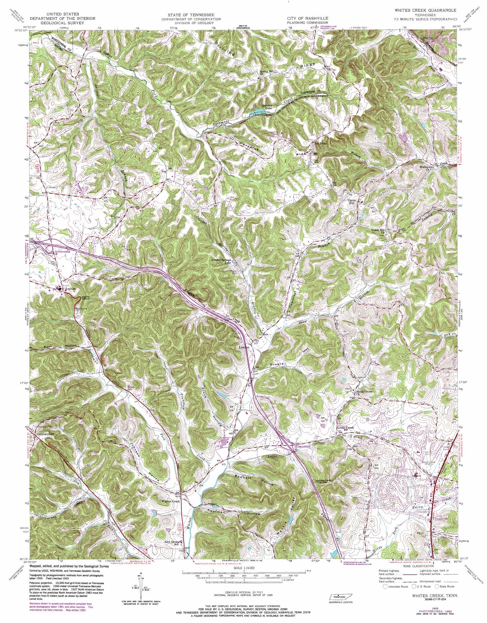
Whites Creek Topo Map Tennessee
To zoom in, hover over the map of Whites Creek
USGS Topo Quad 36086c7 - 1:24,000 scale
| Topo Map Name: | Whites Creek |
| USGS Topo Quad ID: | 36086c7 |
| Print Size: | ca. 21 1/4" wide x 27" high |
| Southeast Coordinates: | 36.25° N latitude / 86.75° W longitude |
| Map Center Coordinates: | 36.3125° N latitude / 86.8125° W longitude |
| U.S. State: | TN |
| Filename: | o36086c7.jpg |
| Download Map JPG Image: | Whites Creek topo map 1:24,000 scale |
| Map Type: | Topographic |
| Topo Series: | 7.5´ |
| Map Scale: | 1:24,000 |
| Source of Map Images: | United States Geological Survey (USGS) |
| Alternate Map Versions: |
Whites Creek TN 1955, updated 1956 Download PDF Buy paper map Whites Creek TN 1955, updated 1967 Download PDF Buy paper map Whites Creek TN 1955, updated 1977 Download PDF Buy paper map Whites Creek TN 1955, updated 1983 Download PDF Buy paper map Whites Creek TN 1994, updated 1997 Download PDF Buy paper map Whites Creek TN 2010 Download PDF Buy paper map Whites Creek TN 2013 Download PDF Buy paper map Whites Creek TN 2016 Download PDF Buy paper map |
1:24,000 Topo Quads surrounding Whites Creek
Adams |
Springfield North |
Youngville |
Orlinda |
Portland |
Pleasant View |
Springfield South |
Greenbrier |
White House |
Cottontown |
Ashland City |
Forest Grove |
Whites Creek |
Goodlettsville |
Hendersonville |
Lillamay |
Scottsboro |
Nashville West |
Nashville East |
Hermitage |
Kingston Springs |
Bellevue |
Oak Hill |
Antioch |
La Vergne |
> Back to 36086a1 at 1:100,000 scale
> Back to 36086a1 at 1:250,000 scale
> Back to U.S. Topo Maps home
Whites Creek topo map: Gazetteer
Whites Creek: Bends
Devils Elbow elevation 220m 721′Whites Creek: Crossings
Interchange 35 elevation 249m 816′Interchange 40 elevation 157m 515′
Whites Creek: Dams
Browns Lake Dam elevation 216m 708′Crocker Springs Dam elevation 189m 620′
Lakewood Dam elevation 171m 561′
Sportsmans Lake Dam elevation 187m 613′
Whites Creek: Parks
Whites Creek Park elevation 148m 485′Whites Creek: Populated Places
Bakers elevation 190m 623′Bellshire elevation 175m 574′
Dalemere elevation 178m 583′
Dry Fork (historical) elevation 153m 501′
Germantown elevation 263m 862′
Ivy Point elevation 281m 921′
Joelton elevation 251m 823′
Lickton elevation 159m 521′
Little Creek elevation 162m 531′
Ridgepost (historical) elevation 252m 826′
Union Hill elevation 239m 784′
Whites Creek elevation 145m 475′
Whites Creek Springs (historical) elevation 170m 557′
Williams Hills elevation 257m 843′
Whites Creek: Post Offices
Joelton Post Office elevation 251m 823′Whites Creek Post Office elevation 142m 465′
Whites Creek: Reservoirs
Browns Lake elevation 216m 708′Crocker Springs Lake elevation 189m 620′
Lakewood Lake elevation 171m 561′
Sportsmans Lake elevation 187m 613′
Whites Creek: Ridges
Dividing Ridge elevation 268m 879′Paradise Ridge elevation 262m 859′
Whites Creek: Streams
Carney Creek elevation 157m 515′Claylick Creek elevation 152m 498′
Crocker Spring Branch elevation 157m 515′
Cummings Branch elevation 162m 531′
Earthman Fork elevation 140m 459′
Little Creek elevation 144m 472′
Shaw Branch elevation 162m 531′
Sulphur Branch elevation 186m 610′
Trantham Creek elevation 139m 456′
Whites Creek: Valleys
Bear Hollow elevation 173m 567′Bennett Hollow elevation 150m 492′
Druard Hollow elevation 153m 501′
Johnson Hollow elevation 147m 482′
Kaufman Hollow elevation 141m 462′
Mackie Valley elevation 159m 521′
Prock Hollow elevation 152m 498′
Whites Creek digital topo map on disk
Buy this Whites Creek topo map showing relief, roads, GPS coordinates and other geographical features, as a high-resolution digital map file on DVD: