Valle Grande Peak Topo Map New Mexico
To zoom in, hover over the map of Valle Grande Peak
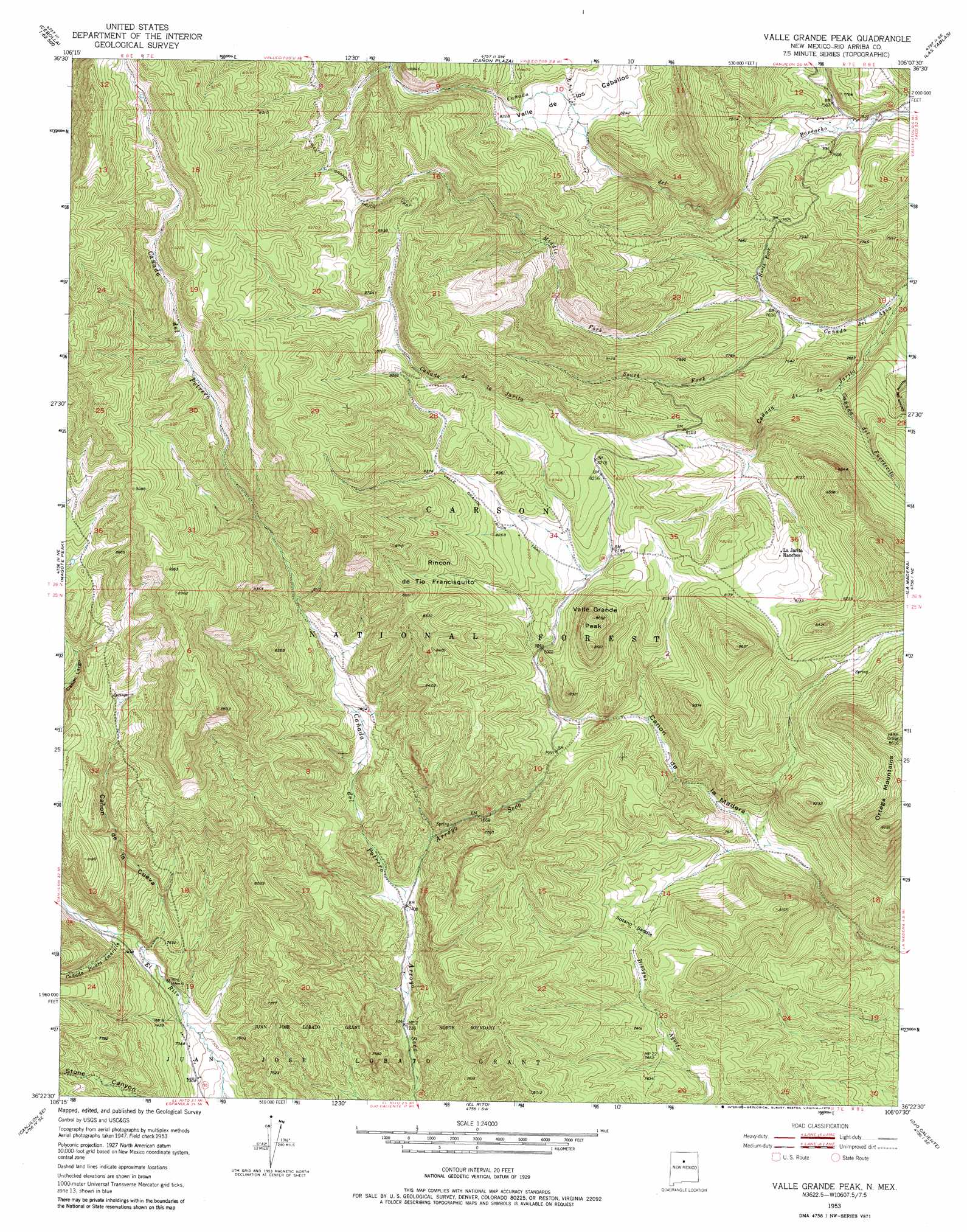
USGS Topo Quad 36106d2 - 1:24,000 scale
| Topo Map Name: | Valle Grande Peak |
| USGS Topo Quad ID: | 36106d2 |
| Print Size: | ca. 21 1/4" wide x 27" high |
| Southeast Coordinates: | 36.375° N latitude / 106.125° W longitude |
| Map Center Coordinates: | 36.4375° N latitude / 106.1875° W longitude |
| U.S. State: | NM |
| Filename: | o36106d2.jpg |
| Download Map JPG Image: | Valle Grande Peak topo map 1:24,000 scale |
| Map Type: | Topographic |
| Topo Series: | 7.5´ |
| Map Scale: | 1:24,000 |
| Source of Map Images: | United States Geological Survey (USGS) |
| Alternate Map Versions: |
Valle Grande Peak NM 1953, updated 1954 Download PDF Buy paper map Valle Grande Peak NM 1953, updated 1968 Download PDF Buy paper map Valle Grande Peak NM 1953, updated 1979 Download PDF Buy paper map Valle Grande Peak NM 1995, updated 1997 Download PDF Buy paper map Valle Grande Peak NM 2011 Download PDF Buy paper map Valle Grande Peak NM 2013 Download PDF Buy paper map Valle Grande Peak NM 2017 Download PDF Buy paper map |
| FStopo: | US Forest Service topo Valle Grande Peak is available: Download FStopo PDF Download FStopo TIF |
1:24,000 Topo Quads surrounding Valle Grande Peak
Penasco Amarillo |
East Gavilan Canyon |
Burned Mountain |
Mule Canyon |
Tres Piedras |
Cebolla |
Canjilon Mountain |
Canon Plaza |
Las Tablas |
Petaca Peak |
Canjilon |
Mogote Peak |
Valle Grande Peak |
La Madera |
Servilleta Plaza |
Ghost Ranch |
Canjilon Se |
El Rito |
Ojo Caliente |
Taos Junction |
Canones |
Abiquiu |
Medanales |
Lyden |
Velarde |
> Back to 36106a1 at 1:100,000 scale
> Back to 36106a1 at 1:250,000 scale
> Back to U.S. Topo Maps home
Valle Grande Peak topo map: Gazetteer
Valle Grande Peak: Basins
Rincon de Tio Francisquito elevation 2538m 8326′Valle Grande Peak: Falls
Petrero Waterfall elevation 2299m 7542′Valle Grande Peak: Gaps
Sotano Saddle elevation 2375m 7791′Valle Grande Peak: Mines
La Madera Mountain elevation 2343m 7687′Valle Grande Peak: Reservoirs
Canon Largo Tank elevation 2599m 8526′Valle Grande Peak: Springs
Arroyo Seco Spring elevation 2313m 7588′Jacal De Palo Spring elevation 2451m 8041′
La Cueva Springs elevation 2496m 8188′
Valle Grande Peak: Streams
Cañada de la Jarita elevation 2261m 7417′Cañada de Potrero elevation 2261m 7417′
Cañada de Puertecito elevation 2328m 7637′
Cañada de Rancho elevation 2312m 7585′
Cañada Piedra Amarilla elevation 2278m 7473′
Middle Fork Cañada del Agua elevation 2332m 7650′
North Fork Cañada del Agua elevation 2332m 7650′
South Fork Cañada del Agua elevation 2313m 7588′
Valle Grande Peak: Summits
Valle Grande Peak elevation 2624m 8608′Valle Grande Peak: Trails
Valle Grande Truck Trail elevation 2696m 8845′Valle Grande Peak: Valleys
Cañon de la Cueva elevation 2265m 7431′Valle Grande Peak digital topo map on disk
Buy this Valle Grande Peak topo map showing relief, roads, GPS coordinates and other geographical features, as a high-resolution digital map file on DVD: