Hepsedam Peak Topo Map California
To zoom in, hover over the map of Hepsedam Peak
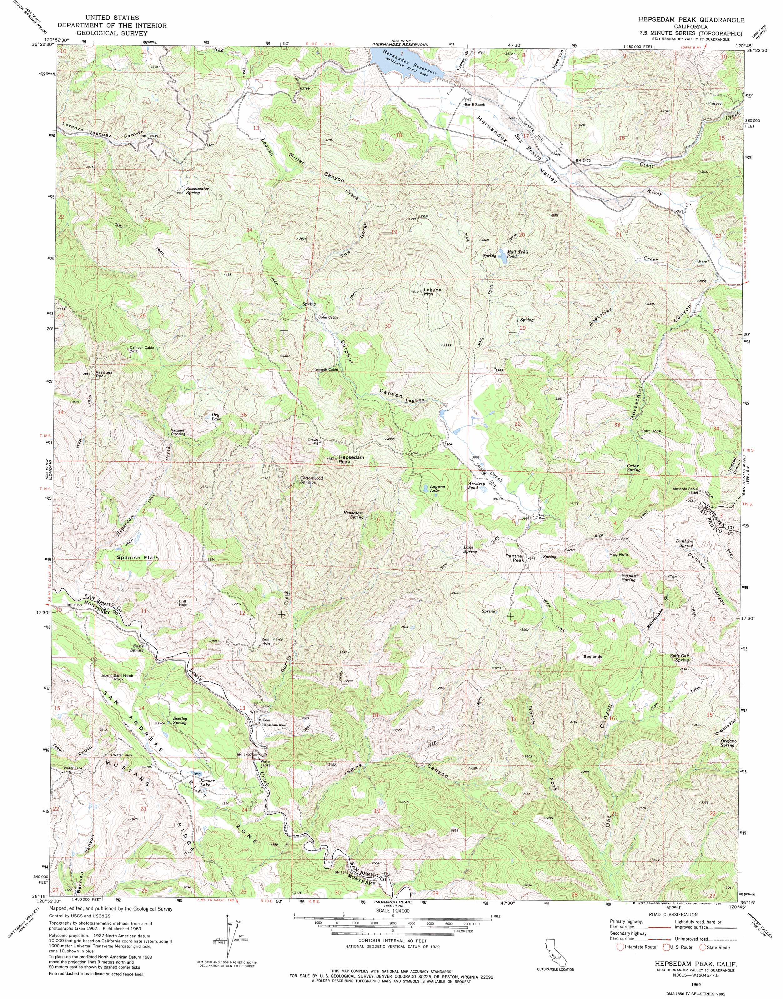
USGS Topo Quad 36120c7 - 1:24,000 scale
| Topo Map Name: | Hepsedam Peak |
| USGS Topo Quad ID: | 36120c7 |
| Print Size: | ca. 21 1/4" wide x 27" high |
| Southeast Coordinates: | 36.25° N latitude / 120.75° W longitude |
| Map Center Coordinates: | 36.3125° N latitude / 120.8125° W longitude |
| U.S. State: | CA |
| Filename: | o36120c7.jpg |
| Download Map JPG Image: | Hepsedam Peak topo map 1:24,000 scale |
| Map Type: | Topographic |
| Topo Series: | 7.5´ |
| Map Scale: | 1:24,000 |
| Source of Map Images: | United States Geological Survey (USGS) |
| Alternate Map Versions: |
Hepsedam Peak CA 1969, updated 1973 Download PDF Buy paper map Hepsedam Peak CA 1969, updated 1980 Download PDF Buy paper map Hepsedam Peak CA 2012 Download PDF Buy paper map Hepsedam Peak CA 2015 Download PDF Buy paper map |
1:24,000 Topo Quads surrounding Hepsedam Peak
San Benito |
Llanada |
Panoche |
Tumey Hills |
Monocline Ridge |
Topo Valley |
Rock Spring Peak |
Hernandez Reservoir |
Idria |
Ciervo Mountain |
Pinalito Canyon |
Lonoak |
Hepsedam Peak |
San Benito Mountain |
Santa Rita Peak |
San Lucas |
Nattrass Valley |
Monarch Peak |
Priest Valley |
Sherman Peak |
Espinosa Canyon |
San Ardo |
Pancho Rico Valley |
Slack Canyon |
Smith Mountain |
> Back to 36120a1 at 1:100,000 scale
> Back to 36120a1 at 1:250,000 scale
> Back to U.S. Topo Maps home
Hepsedam Peak topo map: Gazetteer
Hepsedam Peak: Areas
Badlands elevation 1060m 3477′Hepsedam Peak: Crossings
Vasquez Crossing elevation 712m 2335′Hepsedam Peak: Flats
Orejano Flat elevation 1063m 3487′Spanish Flats elevation 597m 1958′
Hepsedam Peak: Lakes
Airstrip Pond elevation 1192m 3910′Dry Lake elevation 889m 2916′
Hog Hole elevation 1118m 3667′
Kenner Lake elevation 587m 1925′
Laguna Lake elevation 1112m 3648′
Mail Trail Pond elevation 1027m 3369′
Hepsedam Peak: Springs
Bootleg Spring elevation 592m 1942′Cedar Spring elevation 998m 3274′
Cottonwood Springs elevation 990m 3248′
Dunham Spring elevation 1080m 3543′
Hepsedam Spring elevation 912m 2992′
Lake Spring elevation 1070m 3510′
Orejano Spring elevation 1039m 3408′
Split Oak Spring elevation 1045m 3428′
Sulphur Spring elevation 1003m 3290′
Susie Spring elevation 407m 1335′
Sweetwater Spring elevation 950m 3116′
Hepsedam Peak: Streams
Augustine Creek elevation 769m 2522′Clear Creek elevation 748m 2454′
Garcia Creek elevation 422m 1384′
Hepsedam Creek elevation 377m 1236′
Hepsedam Peak: Summits
Gull Neck Rock elevation 610m 2001′Hepsedam Peak elevation 1354m 4442′
Laguna Mountain elevation 1361m 4465′
Panther Peak elevation 1297m 4255′
Split Rock elevation 955m 3133′
Vasquez Rock elevation 1187m 3894′
Hepsedam Peak: Trails
Mail Trail elevation 1100m 3608′Hepsedam Peak: Valleys
Byles Canyon elevation 746m 2447′Hernandez Valley elevation 735m 2411′
Horsethief Canyon elevation 783m 2568′
James Canyon elevation 455m 1492′
Miller Canyon elevation 794m 2604′
North Fork Oak Canyon elevation 630m 2066′
Rattlesnake Gulch elevation 906m 2972′
Sulphur Canyon elevation 1000m 3280′
The Gorge elevation 856m 2808′
Tucker Gulch elevation 733m 2404′
Hepsedam Peak digital topo map on disk
Buy this Hepsedam Peak topo map showing relief, roads, GPS coordinates and other geographical features, as a high-resolution digital map file on DVD: