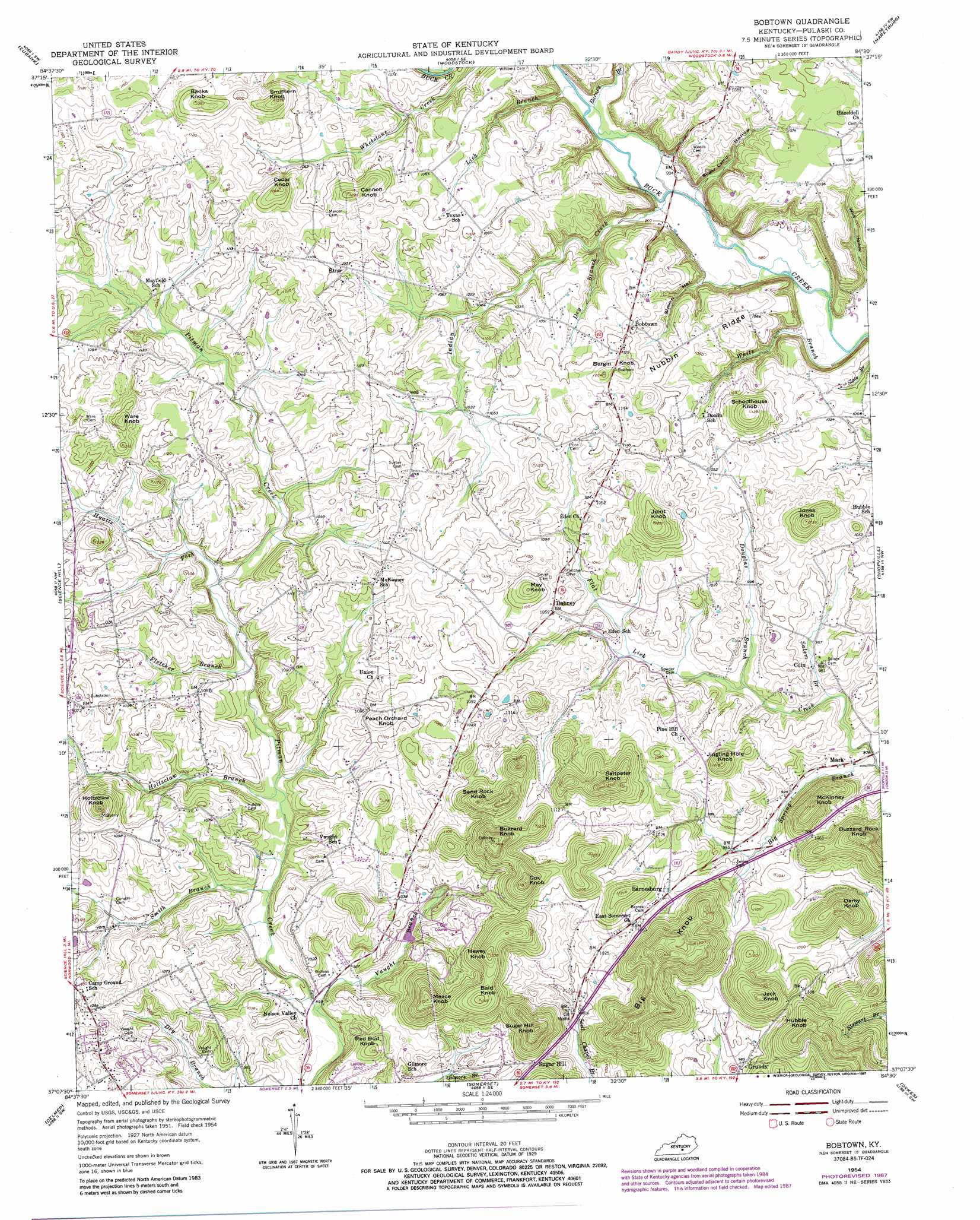
Bobtown Topo Map Kentucky
To zoom in, hover over the map of Bobtown
USGS Topo Quad 37084b5 - 1:24,000 scale
| Topo Map Name: | Bobtown |
| USGS Topo Quad ID: | 37084b5 |
| Print Size: | ca. 21 1/4" wide x 27" high |
| Southeast Coordinates: | 37.125° N latitude / 84.5° W longitude |
| Map Center Coordinates: | 37.1875° N latitude / 84.5625° W longitude |
| U.S. State: | KY |
| Filename: | o37084b5.jpg |
| Download Map JPG Image: | Bobtown topo map 1:24,000 scale |
| Map Type: | Topographic |
| Topo Series: | 7.5´ |
| Map Scale: | 1:24,000 |
| Source of Map Images: | United States Geological Survey (USGS) |
| Alternate Map Versions: |
Bobtown KY 1954, updated 1955 Download PDF Buy paper map Bobtown KY 1954, updated 1972 Download PDF Buy paper map Bobtown KY 1954, updated 1987 Download PDF Buy paper map Bobtown KY 2010 Download PDF Buy paper map Bobtown KY 2013 Download PDF Buy paper map Bobtown KY 2016 Download PDF Buy paper map |
1:24,000 Topo Quads surrounding Bobtown
Hustonville |
Halls Gap |
Crab Orchard |
Brodhead |
Wildie |
Yosemite |
Eubank |
Woodstock |
Maretburg |
Mount Vernon |
Mintonville |
Science Hill |
Bobtown |
Shopville |
Billows |
Faubush |
Delmer |
Somerset |
Dykes |
Ano |
Mill Springs |
Frazer |
Burnside |
Hail |
Sawyer |
> Back to 37084a1 at 1:100,000 scale
> Back to 37084a1 at 1:250,000 scale
> Back to U.S. Topo Maps home
Bobtown topo map: Gazetteer
Bobtown: Populated Places
Barnesburg elevation 314m 1030′Bobtown elevation 332m 1089′
Coin elevation 288m 944′
Dabney elevation 326m 1069′
Etna elevation 330m 1082′
Grundy elevation 302m 990′
Mark elevation 286m 938′
Sugar Hill elevation 333m 1092′
Bobtown: Streams
Barney Branch elevation 274m 898′Big Spring Branch elevation 274m 898′
Douglas Branch elevation 286m 938′
Dry Branch elevation 281m 921′
Fletcher Branch elevation 289m 948′
Holtzclaw Branch elevation 282m 925′
Hyatts Fork elevation 293m 961′
Indian Creek elevation 268m 879′
Lick Branch elevation 270m 885′
Salem Branch elevation 279m 915′
Smith Branch elevation 277m 908′
Vaught Branch elevation 273m 895′
White Branch elevation 266m 872′
Bobtown: Summits
Bald Knob elevation 398m 1305′Banks Knob elevation 383m 1256′
Bergin Knob elevation 366m 1200′
Big Knob elevation 433m 1420′
Buzzard Knob elevation 427m 1400′
Buzzard Rock Knob elevation 428m 1404′
Cannon Knob elevation 362m 1187′
Cedar Knob elevation 389m 1276′
Cox Knob elevation 413m 1354′
Darky Knob elevation 387m 1269′
Hewey Knob elevation 401m 1315′
Holtzclaw Knob elevation 410m 1345′
Hubble Knob elevation 409m 1341′
Jack Knob elevation 399m 1309′
Jingling Hole Knob elevation 366m 1200′
Joint Knob elevation 385m 1263′
Jones Knob elevation 372m 1220′
May Knob elevation 366m 1200′
McKinney Knob elevation 385m 1263′
Meace Knob elevation 414m 1358′
Peach Orchard Knob elevation 361m 1184′
Red Bud Knob elevation 341m 1118′
Saltpeter Knob elevation 406m 1332′
Sand Rock Knob elevation 396m 1299′
Schoolhouse Knob elevation 390m 1279′
Smithern Knob elevation 378m 1240′
Sugar Hill Knob elevation 428m 1404′
Ware Knob elevation 379m 1243′
Bobtown: Valleys
Simon Hollow elevation 276m 905′Sugar Camp Hollow elevation 275m 902′
Wild Hollow elevation 266m 872′
Bobtown digital topo map on disk
Buy this Bobtown topo map showing relief, roads, GPS coordinates and other geographical features, as a high-resolution digital map file on DVD: