Science Hill Topo Map Kentucky
To zoom in, hover over the map of Science Hill
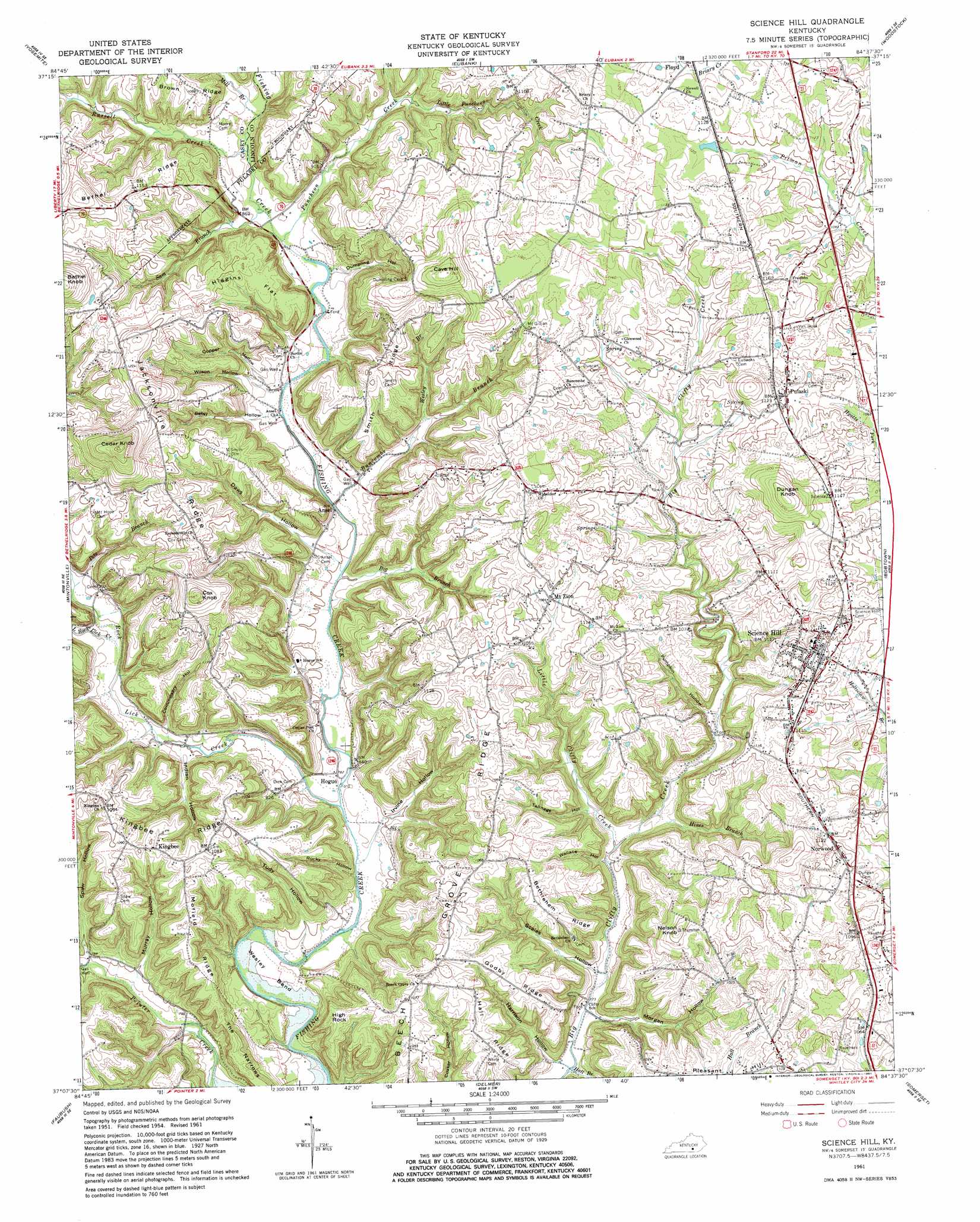
USGS Topo Quad 37084b6 - 1:24,000 scale
| Topo Map Name: | Science Hill |
| USGS Topo Quad ID: | 37084b6 |
| Print Size: | ca. 21 1/4" wide x 27" high |
| Southeast Coordinates: | 37.125° N latitude / 84.625° W longitude |
| Map Center Coordinates: | 37.1875° N latitude / 84.6875° W longitude |
| U.S. State: | KY |
| Filename: | o37084b6.jpg |
| Download Map JPG Image: | Science Hill topo map 1:24,000 scale |
| Map Type: | Topographic |
| Topo Series: | 7.5´ |
| Map Scale: | 1:24,000 |
| Source of Map Images: | United States Geological Survey (USGS) |
| Alternate Map Versions: |
Science Hill KY 1954, updated 1955 Download PDF Buy paper map Science Hill KY 1961, updated 1962 Download PDF Buy paper map Science Hill KY 1961, updated 1981 Download PDF Buy paper map Science Hill KY 2010 Download PDF Buy paper map Science Hill KY 2013 Download PDF Buy paper map Science Hill KY 2016 Download PDF Buy paper map |
1:24,000 Topo Quads surrounding Science Hill
Ellisburg |
Hustonville |
Halls Gap |
Crab Orchard |
Brodhead |
Liberty |
Yosemite |
Eubank |
Woodstock |
Maretburg |
Phil |
Mintonville |
Science Hill |
Bobtown |
Shopville |
Eli |
Faubush |
Delmer |
Somerset |
Dykes |
Jabez |
Mill Springs |
Frazer |
Burnside |
Hail |
> Back to 37084a1 at 1:100,000 scale
> Back to 37084a1 at 1:250,000 scale
> Back to U.S. Topo Maps home
Science Hill topo map: Gazetteer
Science Hill: Bends
Wesley Bend elevation 232m 761′Science Hill: Flats
Higgins Flat elevation 328m 1076′Science Hill: Populated Places
Ansel elevation 244m 800′Hogue elevation 238m 780′
Kingbee elevation 329m 1079′
Mount Zion elevation 330m 1082′
Norwood elevation 342m 1122′
Pulaski elevation 337m 1105′
Science Hill elevation 345m 1131′
Science Hill: Post Offices
Coralee Post Office (historical) elevation 327m 1072′Science Hill: Ridges
Beech Grove Ridge elevation 332m 1089′Bethel Ridge elevation 355m 1164′
Bethlehem Ridge elevation 317m 1040′
Godby Ridge elevation 323m 1059′
Hall Ridge elevation 323m 1059′
Jacksonville Ridge elevation 344m 1128′
Kingbee Ridge elevation 303m 994′
Mofield Ridge elevation 324m 1062′
Smith Ridge elevation 338m 1108′
The Narrows elevation 305m 1000′
Science Hill: Streams
Big Branch elevation 243m 797′Buncombe Branch elevation 244m 800′
Hall Branch elevation 237m 777′
Hines Branch elevation 250m 820′
Line Fork elevation 335m 1099′
Little Clifty Creek elevation 244m 800′
Little Puncheon Creek elevation 274m 898′
Little Rock Lick Creek elevation 252m 826′
Mill Branch elevation 256m 839′
Pete Branch elevation 258m 846′
Puncheon Creek elevation 252m 826′
Rock Lick Creek elevation 236m 774′
Russell Creek elevation 255m 836′
Sam Branch elevation 252m 826′
Wesley Branch elevation 267m 875′
Science Hill: Summits
Cave Hill elevation 411m 1348′Cedar Knob elevation 466m 1528′
Cox Knob elevation 412m 1351′
Dungan Knob elevation 409m 1341′
High Rock elevation 312m 1023′
Nelson Knob elevation 377m 1236′
Pleasant Hill elevation 310m 1017′
Science Hill: Valleys
Betsy Hollow elevation 252m 826′Commissary Hollow elevation 251m 823′
Copper Hollow elevation 260m 853′
Daws Hollow elevation 244m 800′
Dumpling Hollow elevation 256m 839′
Harrison Hollow elevation 236m 774′
Indian Hollow elevation 247m 810′
Irvine Hollow elevation 238m 780′
Morgan Hollow elevation 236m 774′
Murray Hollow elevation 244m 800′
Pumpkin Hollow elevation 262m 859′
Rocky Hollow elevation 232m 761′
Scales Hollow elevation 236m 774′
Spaw Hollow elevation 238m 780′
Talmage Hollow elevation 251m 823′
Tudy Hollow elevation 240m 787′
Wallace Hollow elevation 247m 810′
Wilson Hollow elevation 250m 820′
Science Hill digital topo map on disk
Buy this Science Hill topo map showing relief, roads, GPS coordinates and other geographical features, as a high-resolution digital map file on DVD: