Waltersburg Topo Map Illinois
To zoom in, hover over the map of Waltersburg
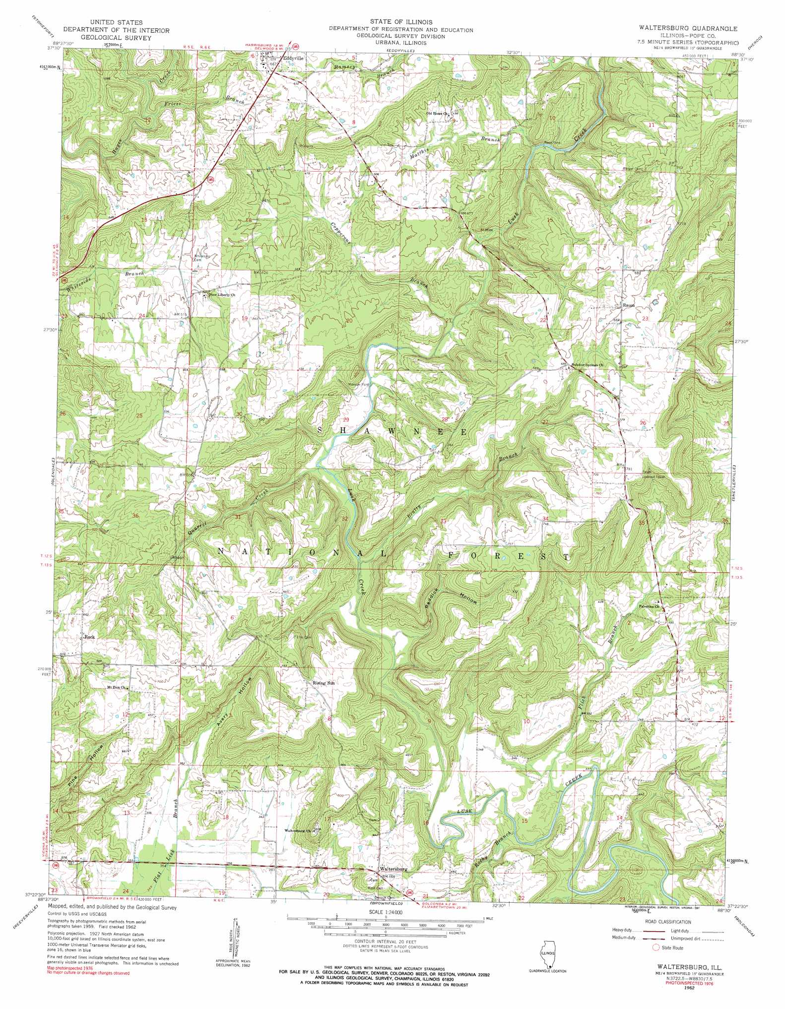
USGS Topo Quad 37088d5 - 1:24,000 scale
| Topo Map Name: | Waltersburg |
| USGS Topo Quad ID: | 37088d5 |
| Print Size: | ca. 21 1/4" wide x 27" high |
| Southeast Coordinates: | 37.375° N latitude / 88.5° W longitude |
| Map Center Coordinates: | 37.4375° N latitude / 88.5625° W longitude |
| U.S. State: | IL |
| Filename: | o37088d5.jpg |
| Download Map JPG Image: | Waltersburg topo map 1:24,000 scale |
| Map Type: | Topographic |
| Topo Series: | 7.5´ |
| Map Scale: | 1:24,000 |
| Source of Map Images: | United States Geological Survey (USGS) |
| Alternate Map Versions: |
Waltersburg IL 1962, updated 1963 Download PDF Buy paper map Waltersburg IL 1962, updated 1991 Download PDF Buy paper map Waltersburg IL 1996, updated 1998 Download PDF Buy paper map Waltersburg IL 1996, updated 1998 Download PDF Buy paper map Waltersburg IL 2012 Download PDF Buy paper map Waltersburg IL 2015 Download PDF Buy paper map |
| FStopo: | US Forest Service topo Waltersburg is available: Download FStopo PDF Download FStopo TIF |
1:24,000 Topo Quads surrounding Waltersburg
Crab Orchard |
Carrier Mills |
Harrisburg |
Rudement |
Equality |
Creal Springs |
Stonefort |
Eddyville |
Herod |
Karbers Ridge |
Bloomfield |
Glendale |
Waltersburg |
Shetlerville |
Rosiclare |
Mermet |
Reevesville |
Brownfield |
Golconda |
Lola |
Joppa |
Metropolis |
Paducah Ne |
Smithland |
Burna |
> Back to 37088a1 at 1:100,000 scale
> Back to 37088a1 at 1:250,000 scale
> Back to U.S. Topo Maps home
Waltersburg topo map: Gazetteer
Waltersburg: Crossings
Anderson Ford elevation 103m 337′Manson Ford elevation 111m 364′
Maynor Ford elevation 139m 456′
Porter Ford elevation 104m 341′
Rose Ford elevation 117m 383′
Waltersburg: Populated Places
Eddyville elevation 213m 698′Raum elevation 214m 702′
Rising Sun elevation 195m 639′
Rock elevation 202m 662′
Waltersburg elevation 143m 469′
Waltersburg: Streams
Beatty Branch elevation 104m 341′Copperous Branch elevation 114m 374′
Flick Branch elevation 97m 318′
Frieze Branch elevation 138m 452′
Little Lusk Creek elevation 118m 387′
Matthis Branch elevation 117m 383′
Quarrel Creek elevation 110m 360′
Ramsey Branch elevation 121m 396′
Randolph Branch elevation 110m 360′
Rocky Branch elevation 97m 318′
Waltersburg: Valleys
Avery Hollow elevation 111m 364′Reddick Hollow elevation 105m 344′
Waltersburg digital topo map on disk
Buy this Waltersburg topo map showing relief, roads, GPS coordinates and other geographical features, as a high-resolution digital map file on DVD: