Powder Mill Ferry Topo Map Missouri
To zoom in, hover over the map of Powder Mill Ferry
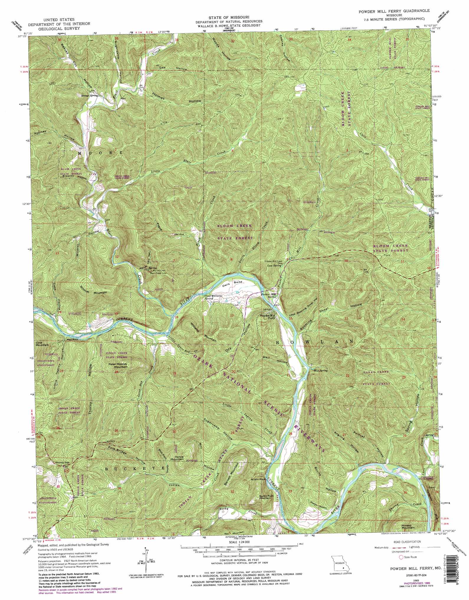
USGS Topo Quad 37091b2 - 1:24,000 scale
| Topo Map Name: | Powder Mill Ferry |
| USGS Topo Quad ID: | 37091b2 |
| Print Size: | ca. 21 1/4" wide x 27" high |
| Southeast Coordinates: | 37.125° N latitude / 91.125° W longitude |
| Map Center Coordinates: | 37.1875° N latitude / 91.1875° W longitude |
| U.S. State: | MO |
| Filename: | o37091b2.jpg |
| Download Map JPG Image: | Powder Mill Ferry topo map 1:24,000 scale |
| Map Type: | Topographic |
| Topo Series: | 7.5´ |
| Map Scale: | 1:24,000 |
| Source of Map Images: | United States Geological Survey (USGS) |
| Alternate Map Versions: |
Powder Mill Ferry MO 1965, updated 1966 Download PDF Buy paper map Powder Mill Ferry MO 1965, updated 1975 Download PDF Buy paper map Powder Mill Ferry MO 1965, updated 1985 Download PDF Buy paper map Powder Mill Ferry MO 1965, updated 1985 Download PDF Buy paper map Powder Mill Ferry MO 1997, updated 2001 Download PDF Buy paper map Powder Mill Ferry MO 2011 Download PDF Buy paper map Powder Mill Ferry MO 2015 Download PDF Buy paper map |
1:24,000 Topo Quads surrounding Powder Mill Ferry
Gladden |
Loggers Lake |
Bunker |
Corridon |
Centerville |
Round Spring |
The Sinks |
Midridge |
Corridon Se |
Redford |
Alley Spring |
Eminence |
Powder Mill Ferry |
Exchange |
Ellington |
Bartlett |
Winona |
Stegall Mountain |
Van Buren North |
Garwood |
Birch Tree |
Low Wassie |
Fremont |
Van Buren South |
Big Spring |
> Back to 37091a1 at 1:100,000 scale
> Back to 37090a1 at 1:250,000 scale
> Back to U.S. Topo Maps home
Powder Mill Ferry topo map: Gazetteer
Powder Mill Ferry: Bays
Goose Bay elevation 172m 564′Powder Mill Ferry: Bends
Owls Bend elevation 177m 580′Powder Mill Ferry: Cliffs
Buttin Rock elevation 192m 629′Cardareva Bluff elevation 186m 610′
Martin Bluff elevation 204m 669′
Red Rock elevation 205m 672′
Powder Mill Ferry: Forests
Blair Creek State Forest elevation 215m 705′Bloom Creek State Forest elevation 268m 879′
Cardareva State Forest elevation 269m 882′
Carrs Creek State Forest elevation 214m 702′
Indian Creek State Forest elevation 245m 803′
Powder Mill State Forest elevation 305m 1000′
Powder Mill Ferry: Gaps
Thorny Gap elevation 302m 990′Powder Mill Ferry: Lakes
Nichols Pond (historical) elevation 335m 1099′Powder Mill Ferry: Parks
Roberts Field Campsite elevation 168m 551′Powder Mill Ferry: Populated Places
Gang elevation 199m 652′Owls Bend elevation 182m 597′
Powder Mill Ferry: Rapids
Coot Chute elevation 177m 580′Powder Mill Ferry: Springs
Blue Spring elevation 176m 577′Clint Williams Spring elevation 171m 561′
Cove Spring elevation 182m 597′
Powder Mill Spring elevation 171m 561′
Stroup Spring elevation 209m 685′
Powder Mill Ferry: Streams
Blair Creek elevation 171m 561′Bloom Creek elevation 171m 561′
Carr Creek elevation 174m 570′
Goose Bay Creek elevation 172m 564′
Indian Creek elevation 166m 544′
Little Blair Creek elevation 187m 613′
Little Bloom Creek elevation 171m 561′
Little Goose Bay Creek elevation 172m 564′
Little Indian Creek elevation 166m 544′
Powder Mill Creek elevation 171m 561′
Rocky Creek elevation 167m 547′
Thorny Creek elevation 177m 580′
Thorny Creek elevation 159m 521′
Powder Mill Ferry: Summits
Barnett Mountain elevation 329m 1079′Buttin Rock Mountain elevation 285m 935′
Peter Mooney Mountain elevation 342m 1122′
Russell Mountain elevation 311m 1020′
Vance Mountain elevation 324m 1062′
Wildcat Mountain elevation 385m 1263′
Williams Mountain elevation 325m 1066′
Powder Mill Ferry: Valleys
Angling Hollow elevation 166m 544′Booming Shoal Hollow elevation 171m 561′
Brawley Hollow elevation 195m 639′
Coot Hollow elevation 177m 580′
Dee Hollow elevation 218m 715′
Dry Hollow elevation 171m 561′
Holmes Hollow elevation 218m 715′
Little Booming Shoal Hollow elevation 171m 561′
Little Thorny Hollow elevation 177m 580′
Martin Hollow elevation 170m 557′
Marvel Cave Hollow elevation 181m 593′
Mill Hollow elevation 189m 620′
Mooney Hollow elevation 199m 652′
Pogue Hollow elevation 192m 629′
Pole Bridge Hollow elevation 214m 702′
Polecat Hollow elevation 165m 541′
Reeves Cox Hollow elevation 207m 679′
Round Hollow elevation 166m 544′
Slick Rock Hollow elevation 210m 688′
Spring Hollow elevation 165m 541′
Sugarcamp Hollow elevation 212m 695′
Sugarcamp Hollow elevation 179m 587′
Thorny Hollow elevation 177m 580′
Well Hollow elevation 170m 557′
Wildcat Hollow elevation 189m 620′
Powder Mill Ferry digital topo map on disk
Buy this Powder Mill Ferry topo map showing relief, roads, GPS coordinates and other geographical features, as a high-resolution digital map file on DVD: