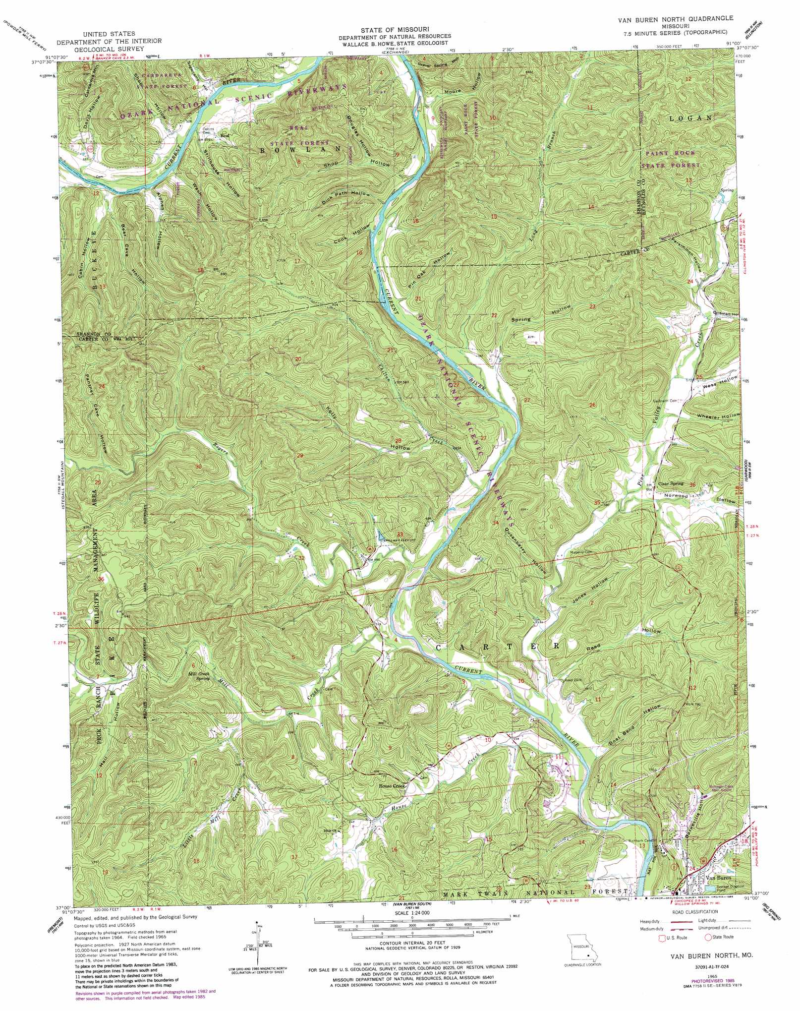
Van Buren North Topo Map Missouri
To zoom in, hover over the map of Van Buren North
USGS Topo Quad 37091a1 - 1:24,000 scale
| Topo Map Name: | Van Buren North |
| USGS Topo Quad ID: | 37091a1 |
| Print Size: | ca. 21 1/4" wide x 27" high |
| Southeast Coordinates: | 37° N latitude / 91° W longitude |
| Map Center Coordinates: | 37.0625° N latitude / 91.0625° W longitude |
| U.S. State: | MO |
| Filename: | o37091a1.jpg |
| Download Map JPG Image: | Van Buren North topo map 1:24,000 scale |
| Map Type: | Topographic |
| Topo Series: | 7.5´ |
| Map Scale: | 1:24,000 |
| Source of Map Images: | United States Geological Survey (USGS) |
| Alternate Map Versions: |
Van Buren North MO 1965, updated 1966 Download PDF Buy paper map Van Buren North MO 1965, updated 1975 Download PDF Buy paper map Van Buren North MO 1965, updated 1985 Download PDF Buy paper map Van Buren North MO 1965, updated 1985 Download PDF Buy paper map Van Buren North MO 1997, updated 1999 Download PDF Buy paper map Van Buren North MO 2011 Download PDF Buy paper map Van Buren North MO 2015 Download PDF Buy paper map |
| FStopo: | US Forest Service topo Van Buren North is available: Download FStopo PDF Download FStopo TIF |
1:24,000 Topo Quads surrounding Van Buren North
The Sinks |
Midridge |
Corridon Se |
Redford |
Lesterville Se |
Eminence |
Powder Mill Ferry |
Exchange |
Ellington |
Clearwater Dam |
Winona |
Stegall Mountain |
Van Buren North |
Garwood |
Ellington Se |
Low Wassie |
Fremont |
Van Buren South |
Big Spring |
Hunter |
Greer |
Wilderness |
Handy |
Grandin Sw |
Grandin |
> Back to 37091a1 at 1:100,000 scale
> Back to 37090a1 at 1:250,000 scale
> Back to U.S. Topo Maps home
Van Buren North topo map: Gazetteer
Van Buren North: Airports
Bollinger-Crass Memorial Airport elevation 178m 583′Van Buren North: Bars
Watermelon Shoal elevation 158m 518′Van Buren North: Bays
Shote Hole elevation 141m 462′Van Buren North: Bends
Boat Bend elevation 142m 465′Van Buren North: Channels
A Quiet Pool elevation 153m 501′Easy Street elevation 145m 475′
Waymeyer Chute elevation 147m 482′
Van Buren North: Cliffs
Bass Rock elevation 151m 495′Van Buren North: Dams
Neil Land Development Corporation North Dam elevation 148m 485′Neil Land Development Corporation South Dam elevation 147m 482′
Van Buren North: Forests
Beal State Forest elevation 253m 830′Cardareva State Forest elevation 214m 702′
Paint Rock State Forest elevation 267m 875′
Van Buren North: Parks
Chilton Creek Campsite elevation 151m 495′Logyard Campsite elevation 162m 531′
Watercress Spring Camp elevation 141m 462′
Watercress Spring Picnic Grounds elevation 141m 462′
Van Buren North: Populated Places
Beal elevation 165m 541′House Creek elevation 181m 593′
Van Buren North: Reservoirs
Deer Run Lake elevation 148m 485′Neil Land Development Corporation Lake elevation 147m 482′
Van Buren North: Springs
Mill Creek Spring elevation 177m 580′Van Buren North: Streams
Chilton Creek elevation 147m 482′House Creek elevation 143m 469′
Little Mill Creek elevation 162m 531′
Long Branch elevation 147m 482′
Mill Creek elevation 144m 472′
Muddy Branch elevation 186m 610′
Pine Valley Creek elevation 142m 465′
Rogers Creek elevation 146m 479′
Van Buren North: Valleys
Alphen Hollow elevation 159m 521′Barnsville Hollow elevation 151m 495′
Bear Cave Hollow elevation 159m 521′
Boat Bend Hollow elevation 142m 465′
Cabin Hollow elevation 164m 538′
Coleman Hollow elevation 181m 593′
Cook Hollow elevation 153m 501′
Davis Hollow elevation 159m 521′
Dick Path Hollow elevation 153m 501′
Douglas Hollow elevation 164m 538′
Dusenberry Hollow elevation 153m 501′
Gravel Spring Hollow elevation 156m 511′
Hail Hollow elevation 187m 613′
Johnson Hollow elevation 189m 620′
Jones Hollow elevation 152m 498′
Kelly Hollow elevation 153m 501′
Moore Hollow elevation 153m 501′
Norwood Hollow elevation 161m 528′
Panther Cave Hollow elevation 189m 620′
Persimmon Hollow elevation 183m 600′
Pin Oak Hollow elevation 151m 495′
Reed Hollow elevation 146m 479′
Shop Hollow elevation 153m 501′
Shop Hollow elevation 159m 521′
Spring Hollow elevation 149m 488′
Stillhouse Hollow elevation 159m 521′
Sugarcamp Hollow elevation 158m 518′
Wash Hollow elevation 159m 521′
Wess Hollow elevation 174m 570′
Wheeler Hollow elevation 172m 564′
Van Buren North digital topo map on disk
Buy this Van Buren North topo map showing relief, roads, GPS coordinates and other geographical features, as a high-resolution digital map file on DVD: