Weminuche Pass Topo Map Colorado
To zoom in, hover over the map of Weminuche Pass
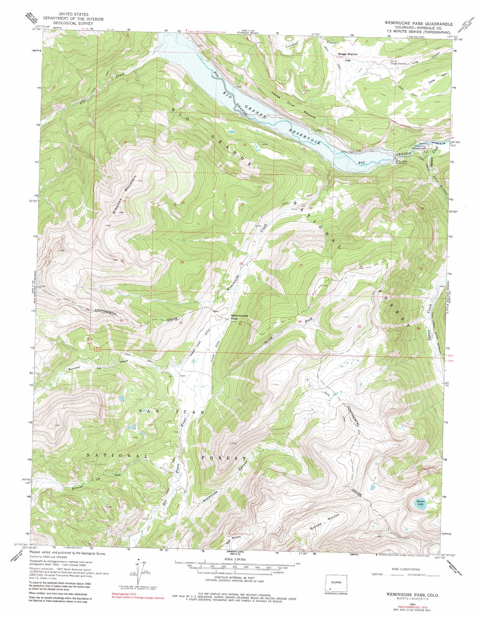
USGS Topo Quad 37107f3 - 1:24,000 scale
| Topo Map Name: | Weminuche Pass |
| USGS Topo Quad ID: | 37107f3 |
| Print Size: | ca. 21 1/4" wide x 27" high |
| Southeast Coordinates: | 37.625° N latitude / 107.25° W longitude |
| Map Center Coordinates: | 37.6875° N latitude / 107.3125° W longitude |
| U.S. State: | CO |
| Filename: | o37107f3.jpg |
| Download Map JPG Image: | Weminuche Pass topo map 1:24,000 scale |
| Map Type: | Topographic |
| Topo Series: | 7.5´ |
| Map Scale: | 1:24,000 |
| Source of Map Images: | United States Geological Survey (USGS) |
| Alternate Map Versions: |
Weminuche Pass CO 1964, updated 1967 Download PDF Buy paper map Weminuche Pass CO 1964, updated 1967 Download PDF Buy paper map Weminuche Pass CO 1964, updated 1980 Download PDF Buy paper map Weminuche Pass CO 2001, updated 2005 Download PDF Buy paper map Weminuche Pass CO 2011 Download PDF Buy paper map Weminuche Pass CO 2013 Download PDF Buy paper map Weminuche Pass CO 2016 Download PDF Buy paper map |
| FStopo: | US Forest Service topo Weminuche Pass is available: Download FStopo PDF Download FStopo TIF |
1:24,000 Topo Quads surrounding Weminuche Pass
Handies Peak |
Redcloud Peak |
Lake San Cristobal |
Slumgullion Pass |
Baldy Cinco |
Howardsville |
Pole Creek Mountain |
Finger Mesa |
Hermit Lakes |
Bristol Head |
Storm King Peak |
Rio Grande Pyramid |
Weminuche Pass |
Little Squaw Creek |
Workman Creek |
Columbine Pass |
Emerald Lake |
Granite Lake |
Cimarrona Peak |
Palomino Mountain |
Vallecito Reservoir |
Granite Peak |
Bear Mountain |
Oakbrush Ridge |
Pagosa Peak |
> Back to 37107e1 at 1:100,000 scale
> Back to 37106a1 at 1:250,000 scale
> Back to U.S. Topo Maps home
Weminuche Pass topo map: Gazetteer
Weminuche Pass: Canals
Fuchs Ditch elevation 3221m 10567′Raber Lohr Ditch elevation 3218m 10557′
Weminuche Pass: Dams
Lost Lake Number 1 Dam elevation 3322m 10898′Rio Grande Dam elevation 2882m 9455′
Squaw Lake Dam elevation 3547m 11637′
Weminuche Pass: Flats
Horse Thief Pasture elevation 3059m 10036′Long Park elevation 3147m 10324′
Stage Station Flat elevation 3123m 10246′
Weminuche Pass: Gaps
Weminuche Pass elevation 3221m 10567′Weminuche Pass: Lakes
Squaw Lake elevation 3547m 11637′Weminuche Pass: Reservoirs
Lost Lake Reservoir Number 1 elevation 3322m 10898′Rio Grande Reservoir elevation 2882m 9455′
Weminuche Pass: Streams
North Fork Los Pinos River elevation 3205m 10515′Squaw Creek elevation 2837m 9307′
Ute Creek elevation 2872m 9422′
Weminuche Creek elevation 2860m 9383′
Weminuche Pass: Summits
Simpson Mountain elevation 3932m 12900′Weminuche Pass: Valleys
Rincon La Osa elevation 3108m 10196′Rincon La Vaca elevation 3219m 10561′
Snowslide Canyon elevation 3096m 10157′
Weminuche Pass digital topo map on disk
Buy this Weminuche Pass topo map showing relief, roads, GPS coordinates and other geographical features, as a high-resolution digital map file on DVD: