Chalfant Valley Topo Map California
To zoom in, hover over the map of Chalfant Valley
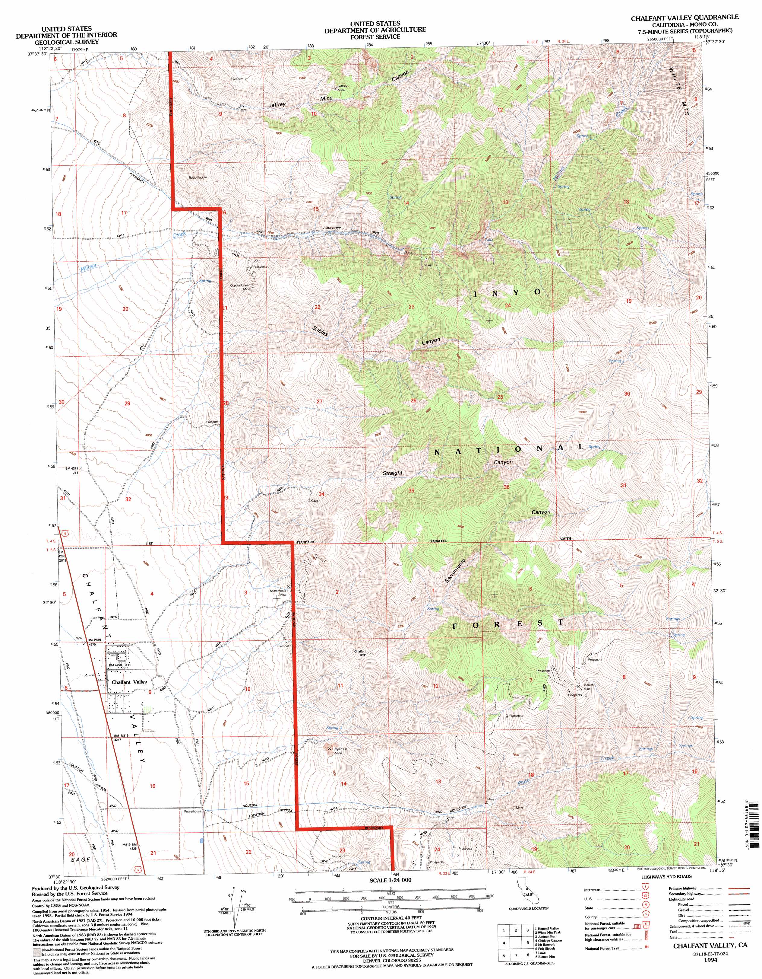
USGS Topo Quad 37118e3 - 1:24,000 scale
| Topo Map Name: | Chalfant Valley |
| USGS Topo Quad ID: | 37118e3 |
| Print Size: | ca. 21 1/4" wide x 27" high |
| Southeast Coordinates: | 37.5° N latitude / 118.25° W longitude |
| Map Center Coordinates: | 37.5625° N latitude / 118.3125° W longitude |
| U.S. State: | CA |
| Filename: | o37118e3.jpg |
| Download Map JPG Image: | Chalfant Valley topo map 1:24,000 scale |
| Map Type: | Topographic |
| Topo Series: | 7.5´ |
| Map Scale: | 1:24,000 |
| Source of Map Images: | United States Geological Survey (USGS) |
| Alternate Map Versions: |
Chalfant Valley CA 1987, updated 1987 Download PDF Buy paper map Chalfant Valley CA 1994, updated 1997 Download PDF Buy paper map Chalfant Valley CA 2012 Download PDF Buy paper map Chalfant Valley CA 2015 Download PDF Buy paper map |
| FStopo: | US Forest Service topo Chalfant Valley is available: Download FStopo PDF Download FStopo TIF |
1:24,000 Topo Quads surrounding Chalfant Valley
Benton Hot Spirngs |
Benton |
Boundary Peak |
Davis Mountain |
East Of Davis Mountain |
Banner Ridge |
Hammil Valley |
White Mountain Peak |
Juniper Mountain |
Dyer |
Casa Diablo Mountain |
Chidago Canyon |
Chalfant Valley |
Mount Barcroft |
Station Peak |
Rovana |
Fish Slough |
Laws |
Blanco Mountain |
Crooked Creek |
Tungsten Hills |
Bishop |
Poleta Canyon |
Westgard Pass |
Deep Springs Lake |
> Back to 37118e1 at 1:100,000 scale
> Back to 37118a1 at 1:250,000 scale
> Back to U.S. Topo Maps home
Chalfant Valley topo map: Gazetteer
Chalfant Valley: Mines
Copper Queen Mine elevation 1936m 6351′Jeffrey Mine elevation 2190m 7185′
Monoco Mine elevation 1940m 6364′
Moulas Mine elevation 2950m 9678′
Piute Mine elevation 1580m 5183′
Sacramento Mine elevation 1571m 5154′
Z and S Mine elevation 2210m 7250′
Chalfant Valley: Populated Places
Chalfant Valley elevation 1298m 4258′Chalfant Valley: Ranges
White Mountains elevation 3698m 12132′Chalfant Valley: Streams
Piute Creek elevation 1303m 4274′Chalfant Valley: Valleys
Jeffrey Mine Canyon elevation 1588m 5209′Sabies Canyon elevation 1652m 5419′
Sacramento Canyon elevation 1554m 5098′
Straight Canyon elevation 1586m 5203′
Chalfant Valley digital topo map on disk
Buy this Chalfant Valley topo map showing relief, roads, GPS coordinates and other geographical features, as a high-resolution digital map file on DVD: