Prince Frederick Topo Map Maryland
To zoom in, hover over the map of Prince Frederick
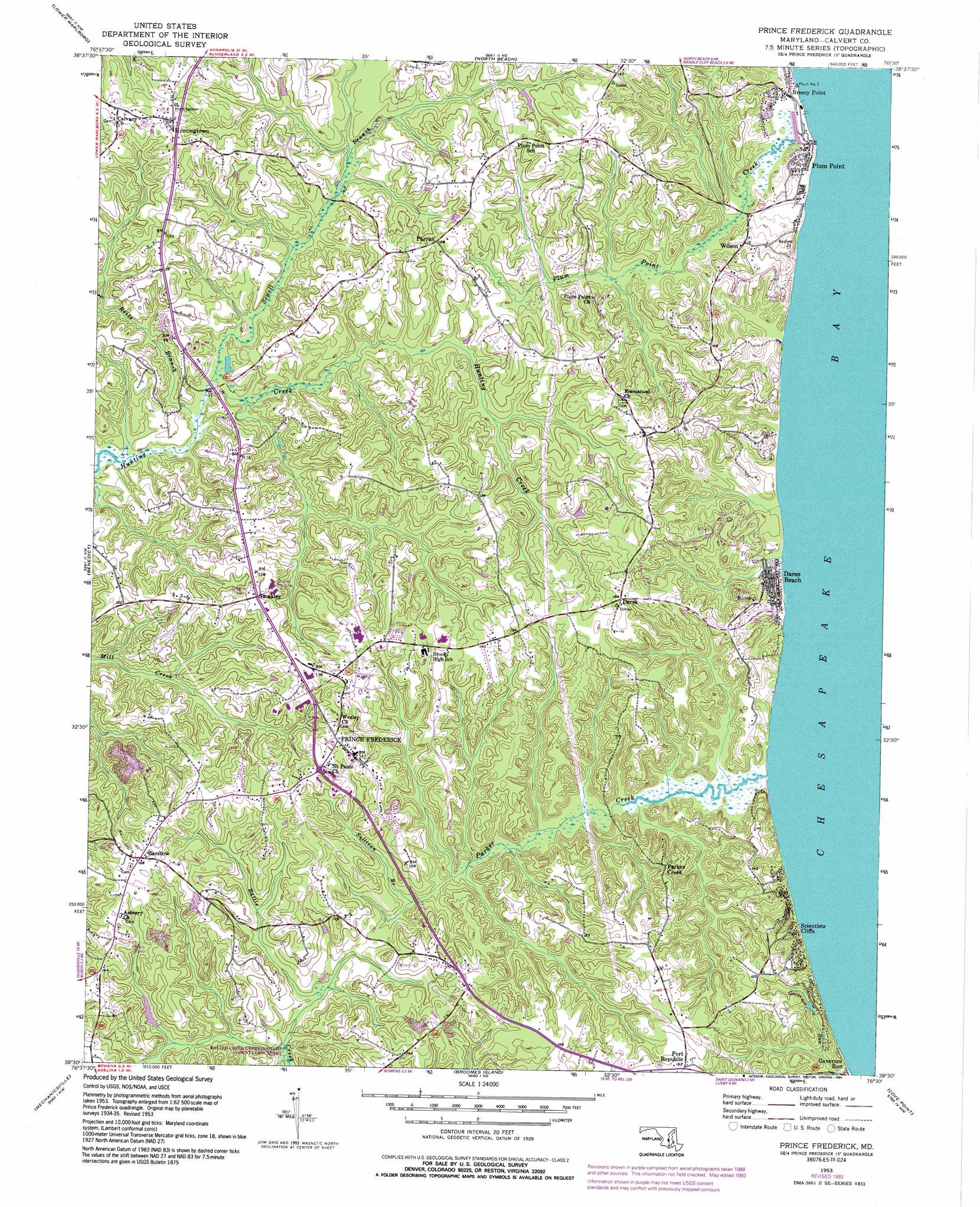
USGS Topo Quad 38076e5 - 1:24,000 scale
| Topo Map Name: | Prince Frederick |
| USGS Topo Quad ID: | 38076e5 |
| Print Size: | ca. 21 1/4" wide x 27" high |
| Southeast Coordinates: | 38.5° N latitude / 76.5° W longitude |
| Map Center Coordinates: | 38.5625° N latitude / 76.5625° W longitude |
| U.S. State: | MD |
| Filename: | o38076e5.jpg |
| Download Map JPG Image: | Prince Frederick topo map 1:24,000 scale |
| Map Type: | Topographic |
| Topo Series: | 7.5´ |
| Map Scale: | 1:24,000 |
| Source of Map Images: | United States Geological Survey (USGS) |
| Alternate Map Versions: |
Prince Frederick MD 1953, updated 1956 Download PDF Buy paper map Prince Frederick MD 1953, updated 1967 Download PDF Buy paper map Prince Frederick MD 1953, updated 1977 Download PDF Buy paper map Prince Frederick MD 1953, updated 1994 Download PDF Buy paper map Prince Frederick MD 2011 Download PDF Buy paper map Prince Frederick MD 2014 Download PDF Buy paper map Prince Frederick MD 2016 Download PDF Buy paper map |
1:24,000 Topo Quads surrounding Prince Frederick
Upper Marlboro |
Bristol |
Deale |
Claiborne |
|
Brandywine |
Lower Marlboro |
North Beach |
Tilghman |
|
Hughesville |
Benedict |
Prince Frederick |
Hudson |
|
Charlotte Hall |
Mechanicsville |
Broomes Island |
Cove Point |
Taylors Island |
Rock Point |
Leonardtown |
Hollywood |
Solomons Island |
Barren Island |
> Back to 38076e1 at 1:100,000 scale
> Back to 38076a1 at 1:250,000 scale
> Back to U.S. Topo Maps home
Prince Frederick topo map: Gazetteer
Prince Frederick: Airports
Calvert Memorial Hospital Heliport elevation 43m 141′Prince Frederick: Capes
Fox Point elevation 3m 9′Plum Point elevation 0m 0′
Prince Frederick: Cliffs
Calvert Cliffs elevation 0m 0′Prince Frederick: Dams
Bowens Farm Pond Dam elevation 21m 68′Gordon Farm Pond Dam elevation 31m 101′
Prince Frederick: Parks
American Chestnut Land Trust elevation 24m 78′Arthur Storer Planetarium elevation 46m 150′
Battle Creek Cypress Swamp County Sanctuary elevation 8m 26′
Calvert County Fairgrounds elevation 42m 137′
Prince Frederick: Populated Places
Angelica elevation 31m 101′Baden Estates elevation 35m 114′
Barstow elevation 47m 154′
Bay Terrace elevation 46m 150′
Bayview Manor Mobile Home Park elevation 27m 88′
Bell Haven elevation 29m 95′
Bellcar elevation 2m 6′
Bess-Mar Estates elevation 34m 111′
Beverly Knolls elevation 36m 118′
Biglanes Choice elevation 32m 104′
Bowen Country elevation 29m 95′
Breezy Point elevation 5m 16′
Buckler Trailer Park elevation 30m 98′
Buena Vista Hills elevation 45m 147′
Calvert Towne elevation 47m 154′
Carpenter Beach elevation 7m 22′
Central Village elevation 42m 137′
Chapel Hill elevation 46m 150′
Chesapeake Heights on the Bay elevation 21m 68′
Clahamman Hills elevation 47m 154′
Dares (historical) elevation 43m 141′
Dares Beach elevation 0m 0′
Deer Crossing elevation 48m 157′
Double Oak Estates elevation 46m 150′
Elen Acres elevation 39m 127′
Fairview Estates elevation 13m 42′
German Chapel Woods elevation 35m 114′
Governor Run elevation 4m 13′
Heather Knolls elevation 30m 98′
Hidden Valley elevation 42m 137′
Hunt Valley Estates elevation 44m 144′
Hunters Ridge elevation 46m 150′
Hunting Creek Farms elevation 27m 88′
Hunting Creek Woods elevation 44m 144′
Hunting Hills elevation 31m 101′
Huntingfields Manor elevation 29m 95′
Huntington (historical) elevation 22m 72′
Huntingtown elevation 49m 160′
Huntingtown Estates elevation 11m 36′
Huntingtown Meadows elevation 43m 141′
Huntingtown Square elevation 55m 180′
Joy Lee Acres elevation 31m 101′
Kingswood Estates elevation 41m 134′
Lord Cecil Woods elevation 5m 16′
Meadow Creek Estates elevation 19m 62′
Meadow Oaks elevation 31m 101′
Mountain Laurel Manor elevation 45m 147′
Neeld Estates elevation 5m 16′
Oldfield elevation 25m 82′
Parkers Creek elevation 41m 134′
Parran elevation 42m 137′
Parran Hunt Estates elevation 34m 111′
Parrans Woods elevation 36m 118′
Patuxent Woods elevation 48m 157′
Peach Blossom Farm elevation 34m 111′
Pendleton elevation 33m 108′
Pine Trailer Park elevation 39m 127′
Pine View Estates elevation 33m 108′
Plum Point elevation 1m 3′
Poplar Woods elevation 30m 98′
Port Republic elevation 44m 144′
Prince Frederick elevation 42m 137′
Queensberry elevation 21m 68′
Quiet Meadows elevation 27m 88′
Radcliffe elevation 34m 111′
Ravenshead elevation 12m 39′
Robshire Manor elevation 15m 49′
Rolling Acres elevation 50m 164′
Rose Hill elevation 40m 131′
Rosewood elevation 45m 147′
Scientists Cliffs elevation 32m 104′
Sherbert elevation 45m 147′
Stoakley elevation 42m 137′
Sunrise elevation 39m 127′
Tanglewood elevation 42m 137′
The Knolls elevation 37m 121′
Tobacco Woods elevation 40m 131′
Tranquility elevation 41m 134′
Turkey Ridge elevation 44m 144′
Turners Field elevation 22m 72′
Valley Lee elevation 44m 144′
Warrington (historical) elevation 20m 65′
Watson Estates elevation 37m 121′
Welland at Barstow elevation 37m 121′
White Marsh Estates elevation 50m 164′
Willowbrook Hills elevation 23m 75′
Wilson elevation 23m 75′
Windcliff elevation 15m 49′
Woodridge elevation 49m 160′
Woodwind Estates elevation 23m 75′
Prince Frederick: Post Offices
Barstow Post Office elevation 49m 160′Dares Wharf Post Office (historical) elevation 35m 114′
Huntingtown Post Office elevation 51m 167′
Plumpoint Post Office (historical) elevation 1m 3′
Prince Frederick Post Office elevation 40m 131′
Prince Frederick: Streams
Parkers Creek elevation 0m 0′Plum Point Creek elevation 0m 0′
Reits Branch elevation 5m 16′
Sewell Branch elevation 3m 9′
Sullivan Branch elevation 18m 59′
Prince Frederick digital topo map on disk
Buy this Prince Frederick topo map showing relief, roads, GPS coordinates and other geographical features, as a high-resolution digital map file on DVD:
Atlantic Coast (NY, NJ, PA, DE, MD, VA, NC)
Buy digital topo maps: Atlantic Coast (NY, NJ, PA, DE, MD, VA, NC)
 map DVD")