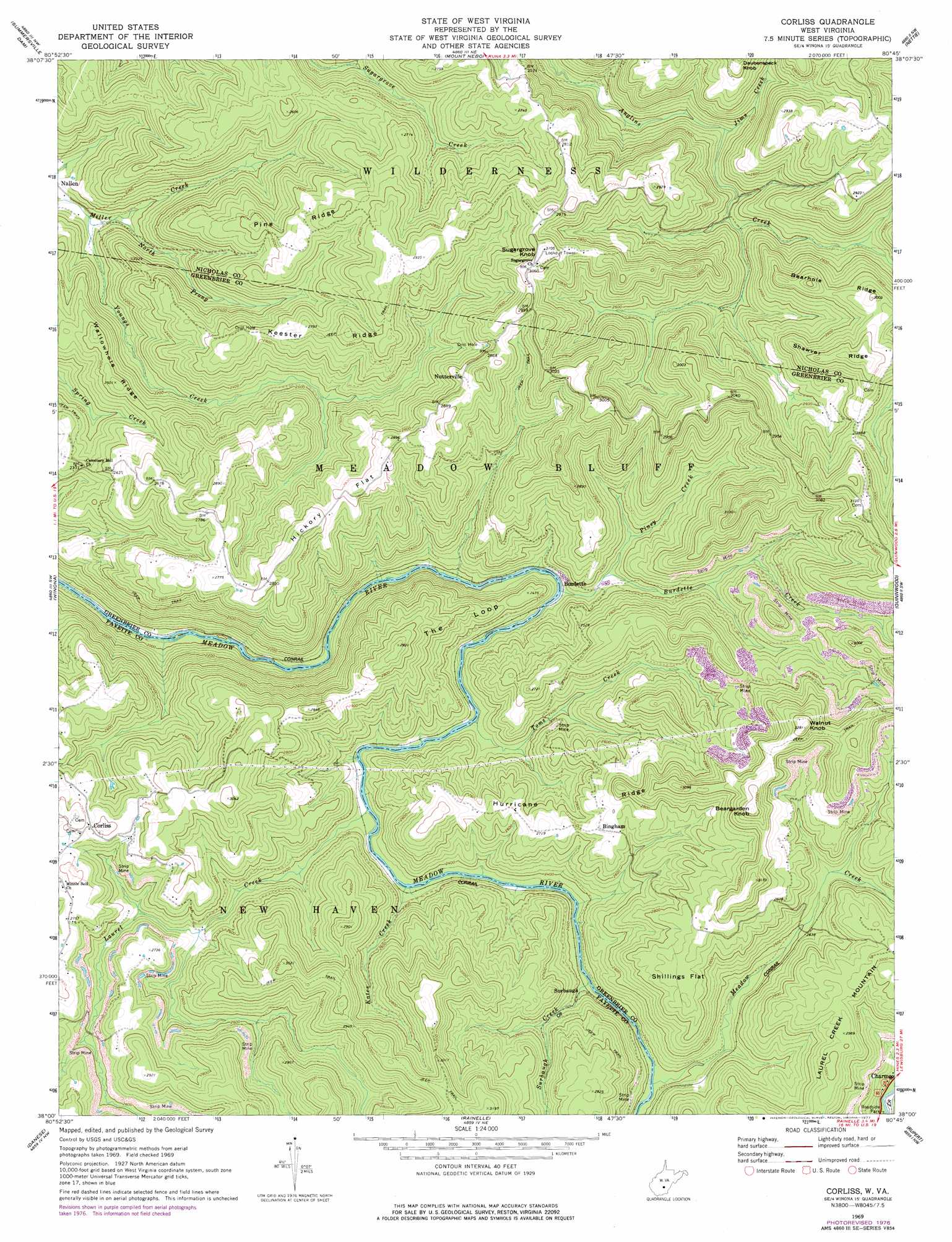
Corliss Topo Map West Virginia
To zoom in, hover over the map of Corliss
USGS Topo Quad 38080a7 - 1:24,000 scale
| Topo Map Name: | Corliss |
| USGS Topo Quad ID: | 38080a7 |
| Print Size: | ca. 21 1/4" wide x 27" high |
| Southeast Coordinates: | 38° N latitude / 80.75° W longitude |
| Map Center Coordinates: | 38.0625° N latitude / 80.8125° W longitude |
| U.S. State: | WV |
| Filename: | o38080a7.jpg |
| Download Map JPG Image: | Corliss topo map 1:24,000 scale |
| Map Type: | Topographic |
| Topo Series: | 7.5´ |
| Map Scale: | 1:24,000 |
| Source of Map Images: | United States Geological Survey (USGS) |
| Alternate Map Versions: |
Corliss WV 1969, updated 1973 Download PDF Buy paper map Corliss WV 1969, updated 1977 Download PDF Buy paper map Corliss WV 2010 Download PDF Buy paper map Corliss WV 2014 Download PDF Buy paper map Corliss WV 2016 Download PDF Buy paper map |
1:24,000 Topo Quads surrounding Corliss
Lockwood |
Gilboa |
Summersville |
Craigsville |
Camden On Gauley |
Ansted |
Summersville Dam |
Mount Nebo |
Nettie |
Richwood |
Fayetteville |
Winona |
Corliss |
Quinwood |
Duo |
Thurmond |
Danese |
Rainelle |
Rupert |
Cornstalk |
Prince |
Meadow Creek |
Meadow Bridge |
Dawson |
Asbury |
> Back to 38080a1 at 1:100,000 scale
> Back to 38080a1 at 1:250,000 scale
> Back to U.S. Topo Maps home
Corliss topo map: Gazetteer
Corliss: Bends
The Loop elevation 775m 2542′Corliss: Crossings
Rader Ford elevation 706m 2316′Corliss: Flats
Hickory Flat elevation 850m 2788′Shillings Flat elevation 885m 2903′
Corliss: Populated Places
Bingham elevation 830m 2723′Burdette elevation 691m 2267′
Corliss elevation 850m 2788′
Honeydew (historical) elevation 715m 2345′
Nutterville elevation 884m 2900′
Surbaugh elevation 725m 2378′
Corliss: Ridges
Bearhole Ridge elevation 880m 2887′Hurricane Ridge elevation 821m 2693′
Keester Ridge elevation 846m 2775′
Pine Ridge elevation 843m 2765′
Shawver Ridge elevation 944m 3097′
Wallowhole Ridge elevation 756m 2480′
Corliss: Streams
Burdette Creek elevation 690m 2263′Jims Creek elevation 693m 2273′
Kates Creek elevation 709m 2326′
Laurel Creek elevation 706m 2316′
Meadow Creek elevation 725m 2378′
Miller Creek elevation 583m 1912′
North Prong Miller Creek elevation 591m 1938′
Piney Creek elevation 708m 2322′
Surbaugh Creek elevation 721m 2365′
Toms Creek elevation 699m 2293′
Corliss: Summits
Beargarden Knob elevation 1007m 3303′Sugargrove Knob elevation 948m 3110′
Walnut Knob elevation 1005m 3297′
Corliss digital topo map on disk
Buy this Corliss topo map showing relief, roads, GPS coordinates and other geographical features, as a high-resolution digital map file on DVD:
Western Virginia & Southern West Virginia
Buy digital topo maps: Western Virginia & Southern West Virginia