Deer Peak Topo Map Colorado
To zoom in, hover over the map of Deer Peak
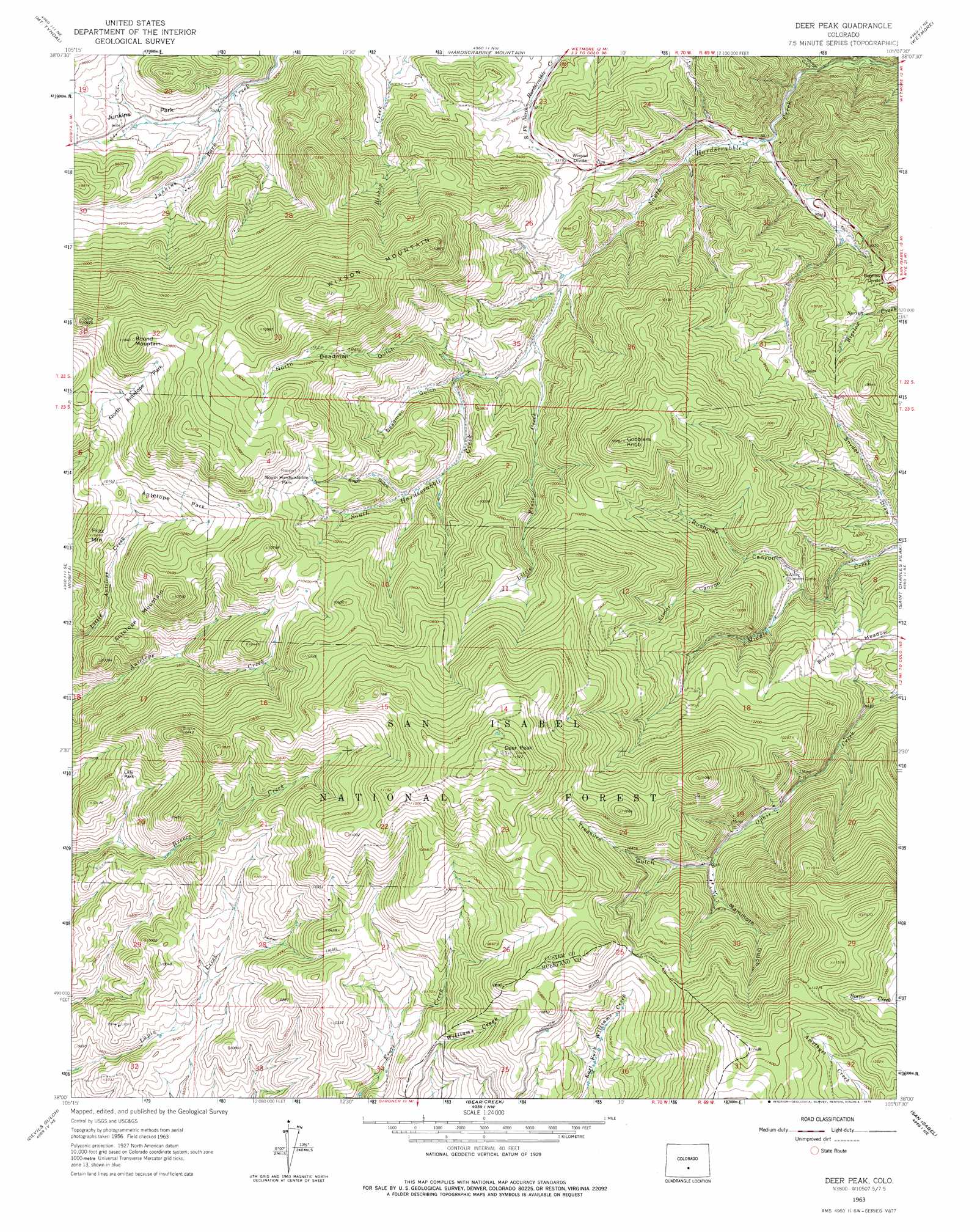
USGS Topo Quad 38105a2 - 1:24,000 scale
| Topo Map Name: | Deer Peak |
| USGS Topo Quad ID: | 38105a2 |
| Print Size: | ca. 21 1/4" wide x 27" high |
| Southeast Coordinates: | 38° N latitude / 105.125° W longitude |
| Map Center Coordinates: | 38.0625° N latitude / 105.1875° W longitude |
| U.S. State: | CO |
| Filename: | o38105a2.jpg |
| Download Map JPG Image: | Deer Peak topo map 1:24,000 scale |
| Map Type: | Topographic |
| Topo Series: | 7.5´ |
| Map Scale: | 1:24,000 |
| Source of Map Images: | United States Geological Survey (USGS) |
| Alternate Map Versions: |
Deer Peak CO 1963, updated 1966 Download PDF Buy paper map Deer Peak CO 1963, updated 1966 Download PDF Buy paper map Deer Peak CO 1963, updated 1975 Download PDF Buy paper map Deer Peak CO 1994, updated 1998 Download PDF Buy paper map Deer Peak CO 2011 Download PDF Buy paper map Deer Peak CO 2013 Download PDF Buy paper map Deer Peak CO 2016 Download PDF Buy paper map |
| FStopo: | US Forest Service topo Deer Peak is available: Download FStopo PDF Download FStopo TIF |
1:24,000 Topo Quads surrounding Deer Peak
Iron Mountain |
Curley Peak |
Rockvale |
Florence Se |
Hobson |
Westcliffe |
Mount Tyndall |
Hardscrabble Mountain |
Wetmore |
Owl Canyon |
Aldrich Gulch |
Rosita |
Deer Peak |
Saint Charles Peak |
Beulah |
Beck Mountain |
Devils Gulch |
Bear Creek |
San Isabel |
Rye |
Medano Pass |
Creager Reservoir |
Gardner |
Badito Cone |
Hayden Butte |
> Back to 38105a1 at 1:100,000 scale
> Back to 38104a1 at 1:250,000 scale
> Back to U.S. Topo Maps home
Deer Peak topo map: Gazetteer
Deer Peak: Flats
Antelope Park elevation 3119m 10232′Burris Meadow elevation 2815m 9235′
Lilly Park elevation 3030m 9940′
North Antelope Park elevation 3171m 10403′
South Hardscrabble Park elevation 3158m 10360′
Deer Peak: Gaps
Bigelow Divide elevation 2866m 9402′Wixson Divide elevation 2863m 9393′
Deer Peak: Mines
Buckeye-Holt Mine elevation 3004m 9855′Gold Crown Number Two Mine elevation 3284m 10774′
Hardin Claim Group Mine elevation 3315m 10875′
Mineral Channel Number Twelve Mine elevation 2956m 9698′
Star Group Mine elevation 3023m 9917′
Wild Goose Mine elevation 3200m 10498′
Deer Peak: Streams
Little Froze Creek elevation 2840m 9317′Deer Peak: Summits
Antelope Mountain elevation 3274m 10741′Deer Peak elevation 3523m 11558′
Gobblers Knob elevation 3270m 10728′
Piltz Mountain elevation 3127m 10259′
Round Mountain elevation 3367m 11046′
Sperry Mountain elevation 3334m 10938′
Wixson Mountain elevation 3295m 10810′
Deer Peak: Valleys
Deadman Gulch elevation 2910m 9547′Elmer Canyon elevation 2898m 9507′
Johnson Gulch elevation 2625m 8612′
Mammoth Gulch elevation 3083m 10114′
North Deadman Gulch elevation 2896m 9501′
Roger Gulch elevation 3004m 9855′
Treasure Gulch elevation 3067m 10062′
Deer Peak digital topo map on disk
Buy this Deer Peak topo map showing relief, roads, GPS coordinates and other geographical features, as a high-resolution digital map file on DVD: