Mussentuchit Flat Topo Map Utah
To zoom in, hover over the map of Mussentuchit Flat
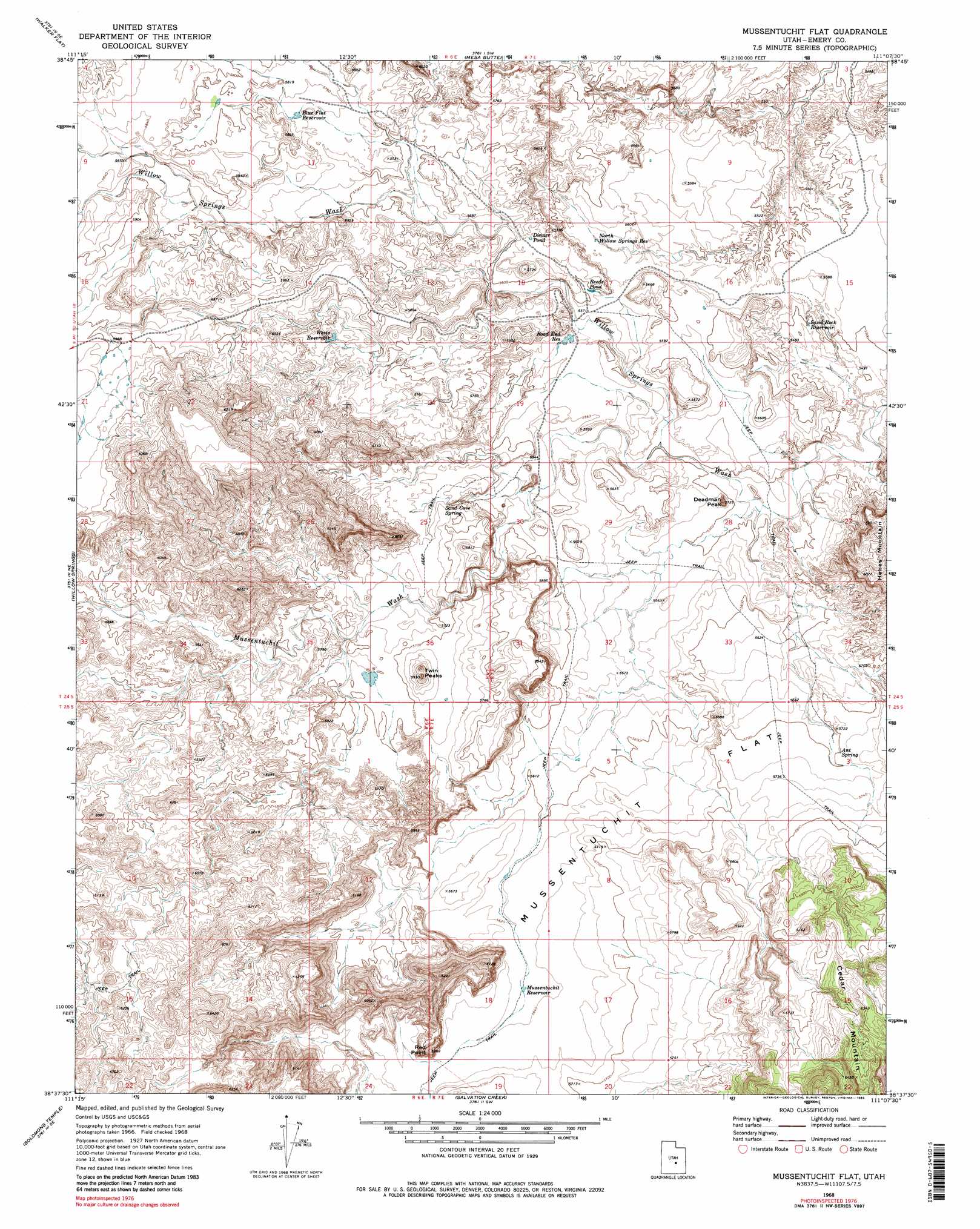
USGS Topo Quad 38111f2 - 1:24,000 scale
| Topo Map Name: | Mussentuchit Flat |
| USGS Topo Quad ID: | 38111f2 |
| Print Size: | ca. 21 1/4" wide x 27" high |
| Southeast Coordinates: | 38.625° N latitude / 111.125° W longitude |
| Map Center Coordinates: | 38.6875° N latitude / 111.1875° W longitude |
| U.S. State: | UT |
| Filename: | o38111f2.jpg |
| Download Map JPG Image: | Mussentuchit Flat topo map 1:24,000 scale |
| Map Type: | Topographic |
| Topo Series: | 7.5´ |
| Map Scale: | 1:24,000 |
| Source of Map Images: | United States Geological Survey (USGS) |
| Alternate Map Versions: |
Mussentuchit Flat UT 1968, updated 1973 Download PDF Buy paper map Mussentuchit Flat UT 1968, updated 1983 Download PDF Buy paper map Mussentuchit Flat UT 1968, updated 1983 Download PDF Buy paper map Mussentuchit Flat UT 2011 Download PDF Buy paper map Mussentuchit Flat UT 2014 Download PDF Buy paper map |
1:24,000 Topo Quads surrounding Mussentuchit Flat
Acord Lakes |
Emery West |
Emery East |
Short Canyon |
Sid And Charley |
Old Woman Plateau |
Walker Flat |
Mesa Butte |
Big Bend Draw |
Copper Globe |
Johns Peak |
Willow Springs |
Mussentuchit Flat |
Ireland Mesa |
Tomsich Butte |
Geyser Peak |
Solomons Temple |
Salvation Creek |
The Frying Pan |
Hunt Draw |
Flat Top |
Cathedral Mountain |
Fruita Nw |
Caine Springs |
Factory Butte |
> Back to 38111e1 at 1:100,000 scale
> Back to 38110a1 at 1:250,000 scale
> Back to U.S. Topo Maps home
Mussentuchit Flat topo map: Gazetteer
Mussentuchit Flat: Flats
Mussentuchit Flat elevation 1722m 5649′Mussentuchit Flat: Lakes
Dinner Pond elevation 1720m 5643′Reeds Pond elevation 1707m 5600′
Mussentuchit Flat: Reservoirs
Blue Flat Reservoir elevation 1752m 5748′Mussentuchit Reservoir elevation 1719m 5639′
Road End Reservoir elevation 1696m 5564′
Wests Reservoir elevation 1750m 5741′
Mussentuchit Flat: Springs
Ant Spring elevation 1738m 5702′North Willow Springs elevation 1690m 5544′
Sand Cove Spring elevation 1709m 5606′
Sand Rock Reservoir elevation 1675m 5495′
Mussentuchit Flat: Summits
Deadman Peak elevation 1743m 5718′Red Point elevation 1818m 5964′
Twin Peaks elevation 1804m 5918′
Mussentuchit Flat: Valleys
Mussentuchit Wash elevation 1696m 5564′Mussentuchit Flat digital topo map on disk
Buy this Mussentuchit Flat topo map showing relief, roads, GPS coordinates and other geographical features, as a high-resolution digital map file on DVD: