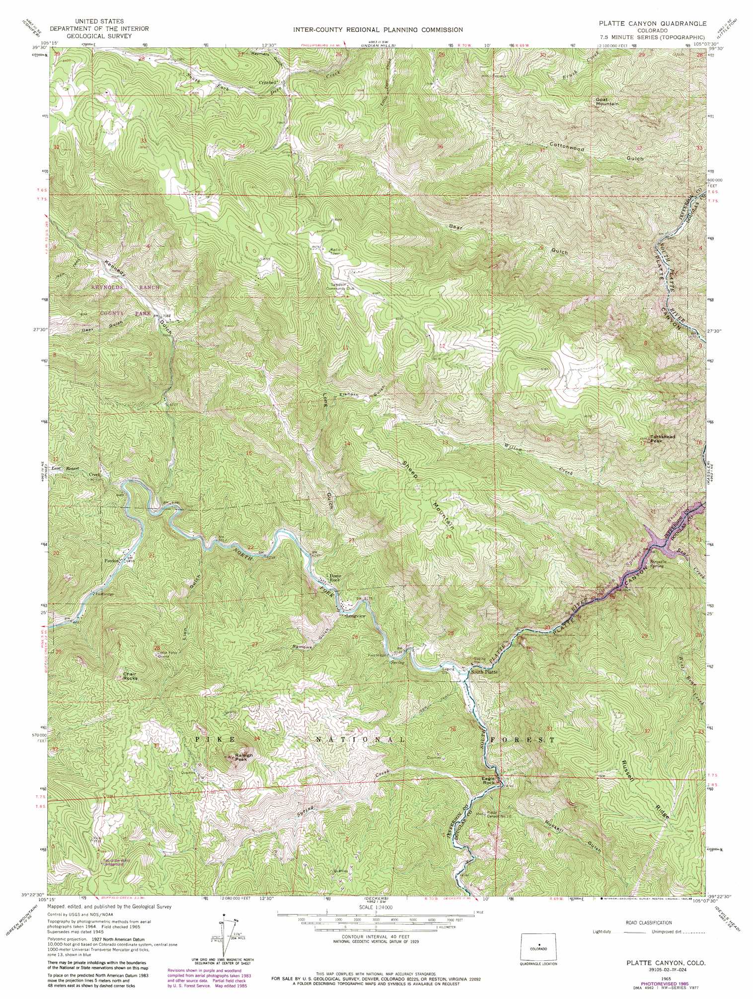
Platte Canyon Topo Map Colorado
To zoom in, hover over the map of Platte Canyon
USGS Topo Quad 39105d2 - 1:24,000 scale
| Topo Map Name: | Platte Canyon |
| USGS Topo Quad ID: | 39105d2 |
| Print Size: | ca. 21 1/4" wide x 27" high |
| Southeast Coordinates: | 39.375° N latitude / 105.125° W longitude |
| Map Center Coordinates: | 39.4375° N latitude / 105.1875° W longitude |
| U.S. State: | CO |
| Filename: | o39105d2.jpg |
| Download Map JPG Image: | Platte Canyon topo map 1:24,000 scale |
| Map Type: | Topographic |
| Topo Series: | 7.5´ |
| Map Scale: | 1:24,000 |
| Source of Map Images: | United States Geological Survey (USGS) |
| Alternate Map Versions: |
Platte Canyon CO 1945, updated 1955 Download PDF Buy paper map Platte Canyon CO 1945, updated 1955 Download PDF Buy paper map Platte Canyon CO 1948 Download PDF Buy paper map Platte Canyon CO 1965, updated 1967 Download PDF Buy paper map Platte Canyon CO 1965, updated 1988 Download PDF Buy paper map Platte Canyon CO 1994, updated 1998 Download PDF Buy paper map Platte Canyon CO 2011 Download PDF Buy paper map Platte Canyon CO 2013 Download PDF Buy paper map Platte Canyon CO 2016 Download PDF Buy paper map |
| FStopo: | US Forest Service topo Platte Canyon is available: Download FStopo PDF Download FStopo TIF |
1:24,000 Topo Quads surrounding Platte Canyon
Squaw Pass |
Evergreen |
Morrison |
Fort Logan |
Englewood |
Meridian Hill |
Conifer |
Indian Hills |
Littleton |
Highlands Ranch |
Bailey |
Pine |
Platte Canyon |
Kassler |
Sedalia |
Windy Peak |
Green Mountain |
Deckers |
Devils Head |
Dawson Butte |
Mccurdy Mountain |
Cheesman Lake |
Westcreek |
Dakan Mountain |
Larkspur |
> Back to 39105a1 at 1:100,000 scale
> Back to 39104a1 at 1:250,000 scale
> Back to U.S. Topo Maps home
Platte Canyon topo map: Gazetteer
Platte Canyon: Mines
Bette Number One Mine elevation 2166m 7106′Black Knight Mine elevation 2417m 7929′
Catherine Number One Claim Mine elevation 2094m 6870′
Delbert Claim Number One Mine elevation 2196m 7204′
Delbert Claim Number Two Mine elevation 2242m 7355′
Judy Ann Claim elevation 2094m 6870′
Little Patsy Mine elevation 2321m 7614′
Little Patsy Quarry elevation 2271m 7450′
Luster Number One Quarries elevation 2321m 7614′
Madonna One Claim Mine elevation 2123m 6965′
Madonna Three Claim Mine elevation 2123m 6965′
Madonna Two Claim Mine elevation 2123m 6965′
Old Luster Lode Pegmatite Mine elevation 2348m 7703′
Oregon Mine elevation 2321m 7614′
Oregon Number One Claim Pegmatite Mine elevation 2234m 7329′
Oregon Number One-and-one-half Quarry elevation 2275m 7463′
Oregon Number Three Quarry elevation 2305m 7562′
Oregon Number Two Quarry elevation 2265m 7431′
Oregon Number Two-and-one-half Quarry elevation 2252m 7388′
Platte Canyon Mine elevation 2422m 7946′
Susy Belle Pegmatite Mine elevation 2094m 6870′
White Cloud Pegmatite Mine elevation 2074m 6804′
Platte Canyon: Parks
Reynolds Ranch County Park elevation 2305m 7562′Platte Canyon: Pillars
Chair Rocks elevation 2408m 7900′Eagle Rock elevation 1946m 6384′
Platte Canyon: Populated Places
Dome Rock elevation 1912m 6272′Foxton elevation 1969m 6459′
Longview elevation 1896m 6220′
South Platte elevation 1859m 6099′
Platte Canyon: Post Offices
Dome Rock Post Office (historical) elevation 1912m 6272′Longview Post Office (historical) elevation 1896m 6220′
Platte Canyon: Reservoirs
Strortia Springs Reservoir elevation 1818m 5964′Platte Canyon: Ridges
Russell Ridge elevation 2439m 8001′Platte Canyon: Springs
Strontia Spring elevation 1847m 6059′Platte Canyon: Streams
Bear Creek elevation 1834m 6017′Last Resort Creek elevation 1961m 6433′
North Fork South Platte River elevation 1858m 6095′
Spring Creek elevation 1870m 6135′
Willow Creek elevation 1834m 6017′
Platte Canyon: Summits
Goat Mountain elevation 2373m 7785′Raleigh Peak elevation 2487m 8159′
Sheep Mountain elevation 2415m 7923′
Turkshead Peak elevation 2356m 7729′
Platte Canyon: Tunnels
Aurora Rampart Tunnel Number 1 elevation 1853m 6079′Platte Canyon: Valleys
Bear Gulch elevation 1722m 5649′Deer Gulch elevation 2155m 7070′
Elkhorn Gulch elevation 2200m 7217′
Kennedy Gulch elevation 1950m 6397′
Lion Gulch elevation 1928m 6325′
Long Gulch elevation 1899m 6230′
Ramona Gulch elevation 1890m 6200′
Raymers Gulch elevation 2335m 7660′
Russell Gulch elevation 1875m 6151′
Platte Canyon digital topo map on disk
Buy this Platte Canyon topo map showing relief, roads, GPS coordinates and other geographical features, as a high-resolution digital map file on DVD: