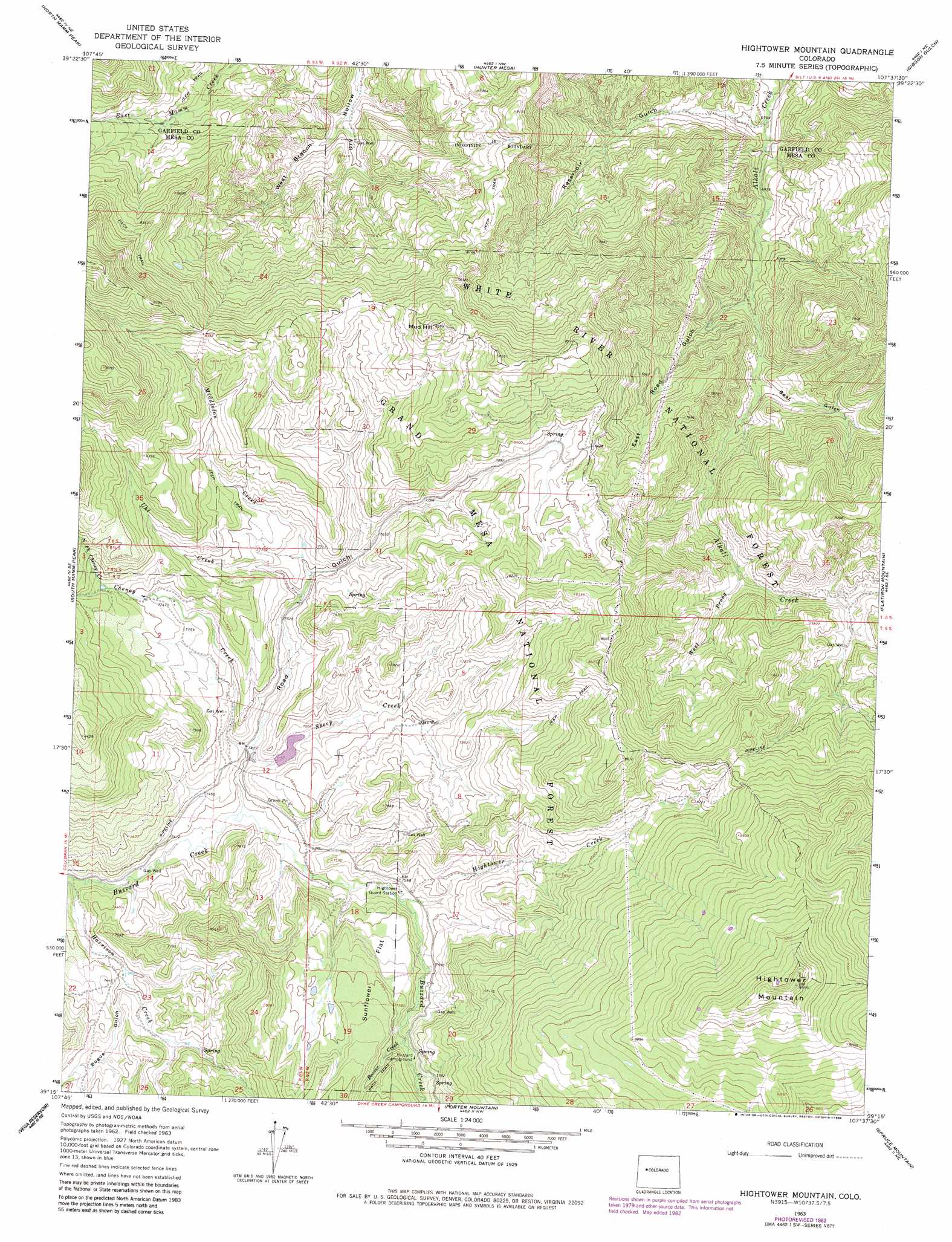
Hightower Mountain Topo Map Colorado
To zoom in, hover over the map of Hightower Mountain
USGS Topo Quad 39107c6 - 1:24,000 scale
| Topo Map Name: | Hightower Mountain |
| USGS Topo Quad ID: | 39107c6 |
| Print Size: | ca. 21 1/4" wide x 27" high |
| Southeast Coordinates: | 39.25° N latitude / 107.625° W longitude |
| Map Center Coordinates: | 39.3125° N latitude / 107.6875° W longitude |
| U.S. State: | CO |
| Filename: | o39107c6.jpg |
| Download Map JPG Image: | Hightower Mountain topo map 1:24,000 scale |
| Map Type: | Topographic |
| Topo Series: | 7.5´ |
| Map Scale: | 1:24,000 |
| Source of Map Images: | United States Geological Survey (USGS) |
| Alternate Map Versions: |
Hightower Mountain CO 1963, updated 1967 Download PDF Buy paper map Hightower Mountain CO 1963, updated 1967 Download PDF Buy paper map Hightower Mountain CO 1963, updated 1982 Download PDF Buy paper map Hightower Mountain CO 1963, updated 1984 Download PDF Buy paper map Hightower Mountain CO 2011 Download PDF Buy paper map Hightower Mountain CO 2013 Download PDF Buy paper map Hightower Mountain CO 2016 Download PDF Buy paper map |
| FStopo: | US Forest Service topo Hightower Mountain is available: Download FStopo PDF Download FStopo TIF |
1:24,000 Topo Quads surrounding Hightower Mountain
Anvil Points |
Rifle |
Silt |
New Castle |
Storm King Mountain |
Rulison |
North Mamm Peak |
Hunter Mesa |
Gibson Gulch |
Center Mountain |
Hawxhurst Creek |
South Mamm Peak |
Hightower Mountain |
Flatiron Mountain |
Quaker Mesa |
Collbran |
The Meadows |
Porter Mountain |
Spruce Mountain |
Elk Knob |
Grand Mesa |
Leon Peak |
Chalk Mountain |
Electric Mountain |
Bull Mountain |
> Back to 39107a1 at 1:100,000 scale
> Back to 39106a1 at 1:250,000 scale
> Back to U.S. Topo Maps home
Hightower Mountain topo map: Gazetteer
Hightower Mountain: Dams
Currier Number 2 Dam elevation 2304m 7559′Hightower Mountain: Flats
Sunflower Flat elevation 2370m 7775′Hightower Mountain: Reservoirs
Currier Number 2 Reservoir elevation 2304m 7559′Hightower Mountain: Springs
Mud Spring elevation 2424m 7952′Hightower Mountain: Streams
Beaver Creek elevation 2332m 7650′Cheney Creek elevation 2257m 7404′
Hightower Creek elevation 2277m 7470′
Middleton Creek elevation 2308m 7572′
North Fork Cheney Creek elevation 2408m 7900′
Sheep Creek elevation 2257m 7404′
Uhl Creek elevation 2300m 7545′
West Prong Alkali Creek elevation 2269m 7444′
Hightower Mountain: Summits
Hightower Mountain elevation 2901m 9517′Mud Hill elevation 2610m 8562′
Hightower Mountain: Valleys
Bear Gulch elevation 2170m 7119′Bogue Gulch elevation 2248m 7375′
East Road Gulch elevation 2139m 7017′
Reservoir Gulch elevation 2061m 6761′
Road Gulch elevation 2242m 7355′
West Branch Dry Hollow elevation 2193m 7194′
Hightower Mountain digital topo map on disk
Buy this Hightower Mountain topo map showing relief, roads, GPS coordinates and other geographical features, as a high-resolution digital map file on DVD: