The Meadows Topo Map Colorado
To zoom in, hover over the map of The Meadows
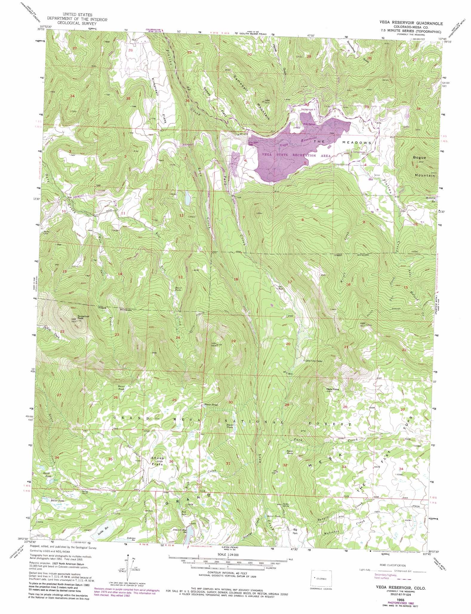
USGS Topo Quad 39107b7 - 1:24,000 scale
| Topo Map Name: | The Meadows |
| USGS Topo Quad ID: | 39107b7 |
| Print Size: | ca. 21 1/4" wide x 27" high |
| Southeast Coordinates: | 39.125° N latitude / 107.75° W longitude |
| Map Center Coordinates: | 39.1875° N latitude / 107.8125° W longitude |
| U.S. State: | CO |
| Filename: | o39107b7.jpg |
| Download Map JPG Image: | The Meadows topo map 1:24,000 scale |
| Map Type: | Topographic |
| Topo Series: | 7.5´ |
| Map Scale: | 1:24,000 |
| Source of Map Images: | United States Geological Survey (USGS) |
| Alternate Map Versions: |
The Meadows CO 1955, updated 1957 Download PDF Buy paper map The Meadows CO 1955, updated 1957 Download PDF Buy paper map The Meadows CO 1955, updated 1963 Download PDF Buy paper map The Meadows CO 1955, updated 1963 Download PDF Buy paper map The Meadows CO 1955, updated 1974 Download PDF Buy paper map The Meadows CO 1955, updated 1974 Download PDF Buy paper map The Meadows CO 1955, updated 1981 Download PDF Buy paper map Vega Reservoir CO 1955, updated 1984 Download PDF Buy paper map Vega Reservoir CO 2011 Download PDF Buy paper map Vega Reservoir CO 2013 Download PDF Buy paper map Vega Reservoir CO 2016 Download PDF Buy paper map |
| FStopo: | US Forest Service topo Vega Reservoir is available: Download FStopo PDF Download FStopo TIF |
1:24,000 Topo Quads surrounding The Meadows
Parachute |
Rulison |
North Mamm Peak |
Hunter Mesa |
Gibson Gulch |
Housetop Mountain |
Hawxhurst Creek |
South Mamm Peak |
Hightower Mountain |
Flatiron Mountain |
Molina |
Collbran |
The Meadows |
Porter Mountain |
Spruce Mountain |
Mesa Lakes |
Grand Mesa |
Leon Peak |
Chalk Mountain |
Electric Mountain |
Hells Kitchen |
Cedaredge |
Dry Creek |
Gray Reservoir |
Bowie |
> Back to 39107a1 at 1:100,000 scale
> Back to 39106a1 at 1:250,000 scale
> Back to U.S. Topo Maps home
The Meadows topo map: Gazetteer
The Meadows: Canals
Erie Canal elevation 2475m 8120′The Meadows: Dams
Anderson Brothers Number 1 Dam elevation 3129m 10265′Grove Creek Number 1 Dam elevation 3160m 10367′
Grove Creek Number 2 Dam elevation 3173m 10410′
McKelvie Number 1 Dam elevation 2543m 8343′
Vega Dam elevation 2429m 7969′
The Meadows: Flats
Big Park elevation 2908m 9540′Kirkendall Flats elevation 2341m 7680′
Sheep Flats elevation 3126m 10255′
Swede Flats elevation 2391m 7844′
The Meadows (historical) elevation 2432m 7979′
The Meadows: Reservoirs
Anderson Brothers Reservoir elevation 3109m 10200′Anderson Brothers Reservoir Number 1 elevation 3129m 10265′
Anderson Reservoir elevation 3185m 10449′
Grove Creek Reservoir Number 1 elevation 3160m 10367′
Grove Creek Reservoir Number 2 elevation 3173m 10410′
Labbe Reservoir elevation 3149m 10331′
McKelvie Reservoir elevation 2540m 8333′
McKelvie Reservoir Number 1 elevation 2543m 8343′
Rock Lake elevation 3093m 10147′
Vega Reservoir elevation 2429m 7969′
The Meadows: Ridges
Hads Point elevation 3060m 10039′The Meadows: Springs
Goody Spring elevation 2880m 9448′The Meadows: Streams
Anne Holland Creek elevation 2543m 8343′East Salt Creek elevation 2220m 7283′
Leon Creek elevation 2267m 7437′
Park Creek elevation 2312m 7585′
Ranger Creek elevation 2829m 9281′
Two Creek elevation 2534m 8313′
West Salt Creek elevation 2220m 7283′
Wilson Creek elevation 2459m 8067′
Youngs Creek elevation 2834m 9297′
The Meadows: Summits
Boque Mountain elevation 2734m 8969′Campbell Mountain elevation 2682m 8799′
Sugarloaf Peak elevation 2792m 9160′
The Meadows digital topo map on disk
Buy this The Meadows topo map showing relief, roads, GPS coordinates and other geographical features, as a high-resolution digital map file on DVD: