Manti Topo Map Utah
To zoom in, hover over the map of Manti
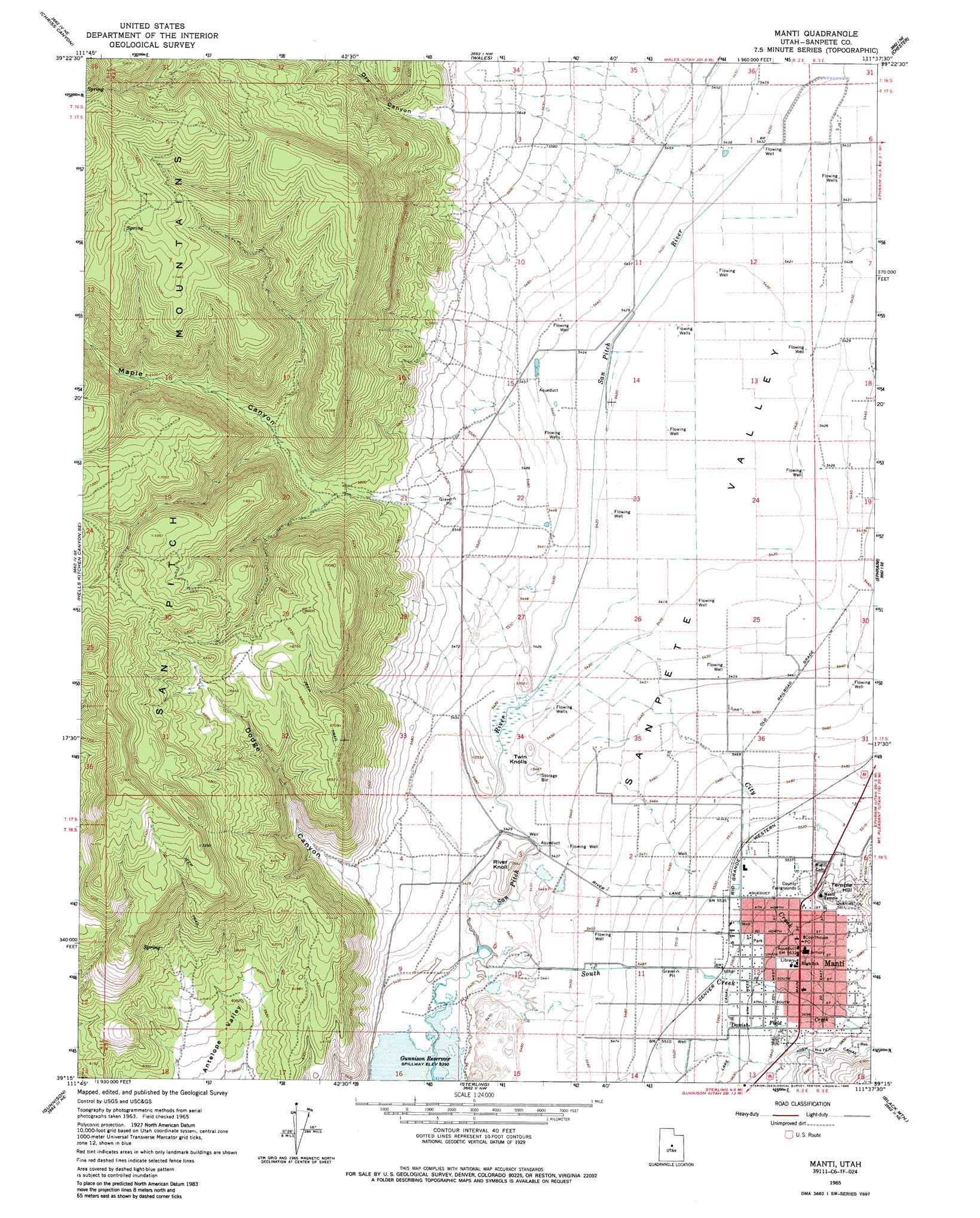
USGS Topo Quad 39111c6 - 1:24,000 scale
| Topo Map Name: | Manti |
| USGS Topo Quad ID: | 39111c6 |
| Print Size: | ca. 21 1/4" wide x 27" high |
| Southeast Coordinates: | 39.25° N latitude / 111.625° W longitude |
| Map Center Coordinates: | 39.3125° N latitude / 111.6875° W longitude |
| U.S. State: | UT |
| Filename: | o39111c6.jpg |
| Download Map JPG Image: | Manti topo map 1:24,000 scale |
| Map Type: | Topographic |
| Topo Series: | 7.5´ |
| Map Scale: | 1:24,000 |
| Source of Map Images: | United States Geological Survey (USGS) |
| Alternate Map Versions: |
Manti UT 1965, updated 1967 Download PDF Buy paper map Manti UT 1965, updated 1985 Download PDF Buy paper map Manti UT 2011 Download PDF Buy paper map Manti UT 2014 Download PDF Buy paper map |
1:24,000 Topo Quads surrounding Manti
Juab |
Levan |
Fountain Green South |
Moroni |
Mount Pleasant |
Skinner Peaks |
Chriss Canyon |
Wales |
Chester |
Spring City |
Hells Kitchen Canyon Sw |
Hells Kitchen Canyon Se |
Manti |
Ephraim |
Danish Knoll |
Hayes Canyon |
Gunnison |
Sterling |
Black Mountain |
Ferron Reservoir |
Redmond Canyon |
Redmond |
Mayfield |
Woods Lake |
Heliotrope Mountain |
> Back to 39111a1 at 1:100,000 scale
> Back to 39110a1 at 1:250,000 scale
> Back to U.S. Topo Maps home
Manti topo map: Gazetteer
Manti: Canals
High Water Canal elevation 1806m 5925′Manti: Parks
South Neba Wildlife Management Area elevation 2010m 6594′Manti: Populated Places
Manti elevation 1710m 5610′Manti: Post Offices
Manti Post Office elevation 1713m 5620′Manti: Streams
City Creek elevation 1658m 5439′South Creek elevation 1644m 5393′
Manti: Summits
River Knoll elevation 1712m 5616′Temple Hill elevation 1705m 5593′
Twin Knolls elevation 1661m 5449′
Manti: Valleys
Dodge Canyon elevation 1670m 5479′Dry Canyon elevation 1763m 5784′
Maple Canyon elevation 1752m 5748′
Sanpete Valley elevation 1665m 5462′
Manti digital topo map on disk
Buy this Manti topo map showing relief, roads, GPS coordinates and other geographical features, as a high-resolution digital map file on DVD: