C Canyon Topo Map Utah
To zoom in, hover over the map of C Canyon
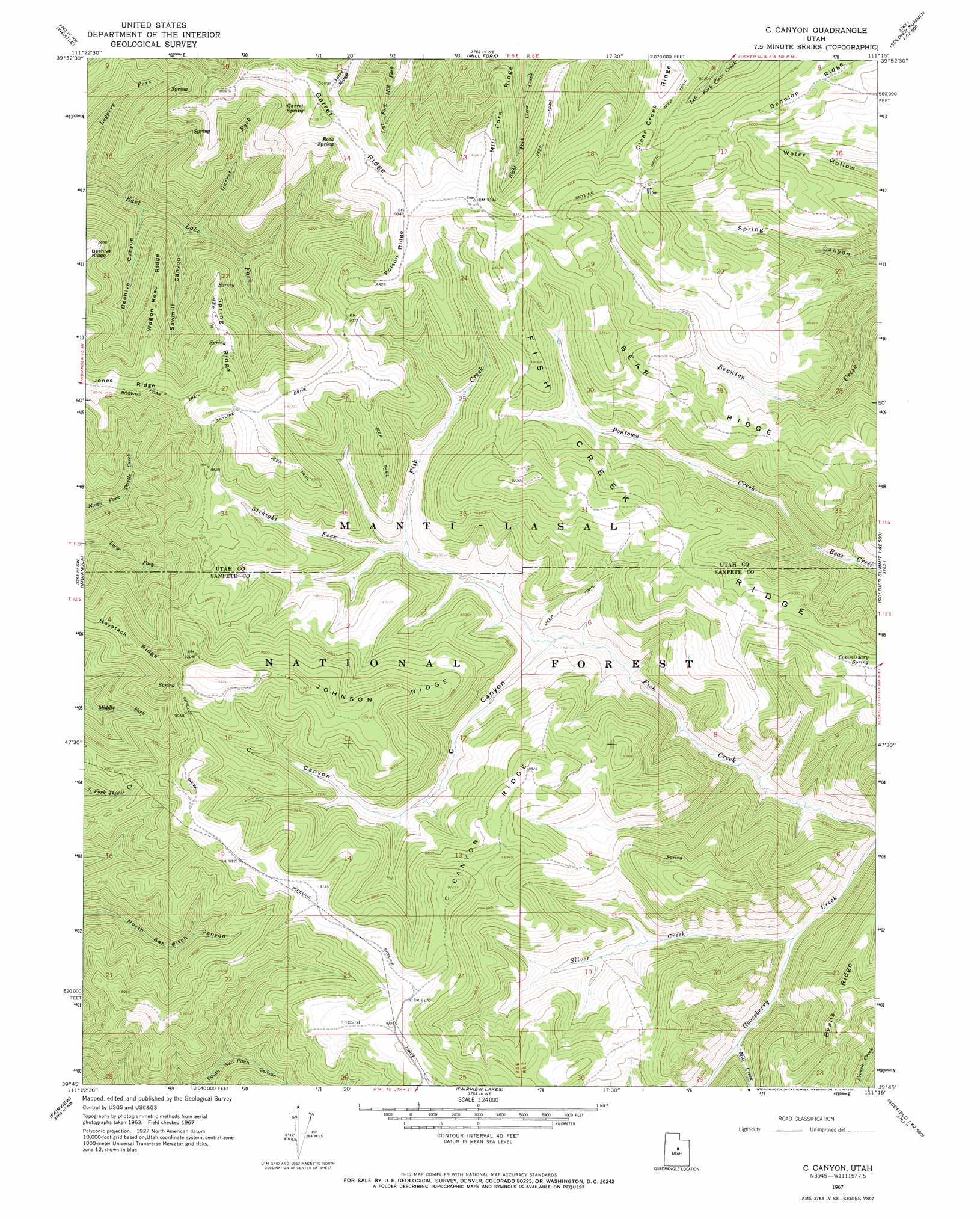
USGS Topo Quad 39111g3 - 1:24,000 scale
| Topo Map Name: | C Canyon |
| USGS Topo Quad ID: | 39111g3 |
| Print Size: | ca. 21 1/4" wide x 27" high |
| Southeast Coordinates: | 39.75° N latitude / 111.25° W longitude |
| Map Center Coordinates: | 39.8125° N latitude / 111.3125° W longitude |
| U.S. State: | UT |
| Filename: | o39111g3.jpg |
| Download Map JPG Image: | C Canyon topo map 1:24,000 scale |
| Map Type: | Topographic |
| Topo Series: | 7.5´ |
| Map Scale: | 1:24,000 |
| Source of Map Images: | United States Geological Survey (USGS) |
| Alternate Map Versions: |
C Canyon UT 1967, updated 1970 Download PDF Buy paper map C Canyon UT 2001, updated 2004 Download PDF Buy paper map C Canyon UT 2011 Download PDF Buy paper map C Canyon UT 2014 Download PDF Buy paper map |
| FStopo: | US Forest Service topo C Canyon is available: Download FStopo PDF Download FStopo TIF |
1:24,000 Topo Quads surrounding C Canyon
Spanish Fork Peak |
Billies Mountain |
Rays Valley |
Strawberry Reservoir Sw |
Strawberry Reservoir Se |
Birdseye |
Thistle |
Mill Fork |
Tucker |
Soldier Summit |
Spencer Canyon |
Indianola |
C Canyon |
Scofield Reservoir |
Colton |
Big Hollow |
Fairview |
Fairview Lakes |
Scofield |
Jump Creek |
Moroni |
Mount Pleasant |
Huntington Reservoir |
Candland Mountain |
Wattis |
> Back to 39111e1 at 1:100,000 scale
> Back to 39110a1 at 1:250,000 scale
> Back to U.S. Topo Maps home
C Canyon topo map: Gazetteer
C Canyon: Ridges
Bean Ridge elevation 2694m 8838′Bear Ridge elevation 2734m 8969′
C Canyon Ridge elevation 2685m 8809′
Fish Creek Ridge elevation 2746m 9009′
Garret Ridge elevation 2800m 9186′
Johnson Ridge elevation 2762m 9061′
Poison Ridge elevation 2845m 9333′
Spring Ridge elevation 2695m 8841′
Wagon Road Ridge elevation 2595m 8513′
C Canyon: Springs
Commissary Spring elevation 2730m 8956′Garret Spring elevation 2707m 8881′
Rock Spring elevation 2760m 9055′
C Canyon: Streams
Garret Fork elevation 2388m 7834′Mill Creek elevation 2422m 7946′
Silver Creek elevation 2398m 7867′
Straight Fork elevation 2519m 8264′
C Canyon: Trails
Fish Creek National Recreation Trail elevation 2424m 7952′C Canyon: Valleys
Beehive Canyon elevation 2344m 7690′C Canyon elevation 2471m 8106′
Sawmill Canyon elevation 2378m 7801′
C Canyon digital topo map on disk
Buy this C Canyon topo map showing relief, roads, GPS coordinates and other geographical features, as a high-resolution digital map file on DVD: