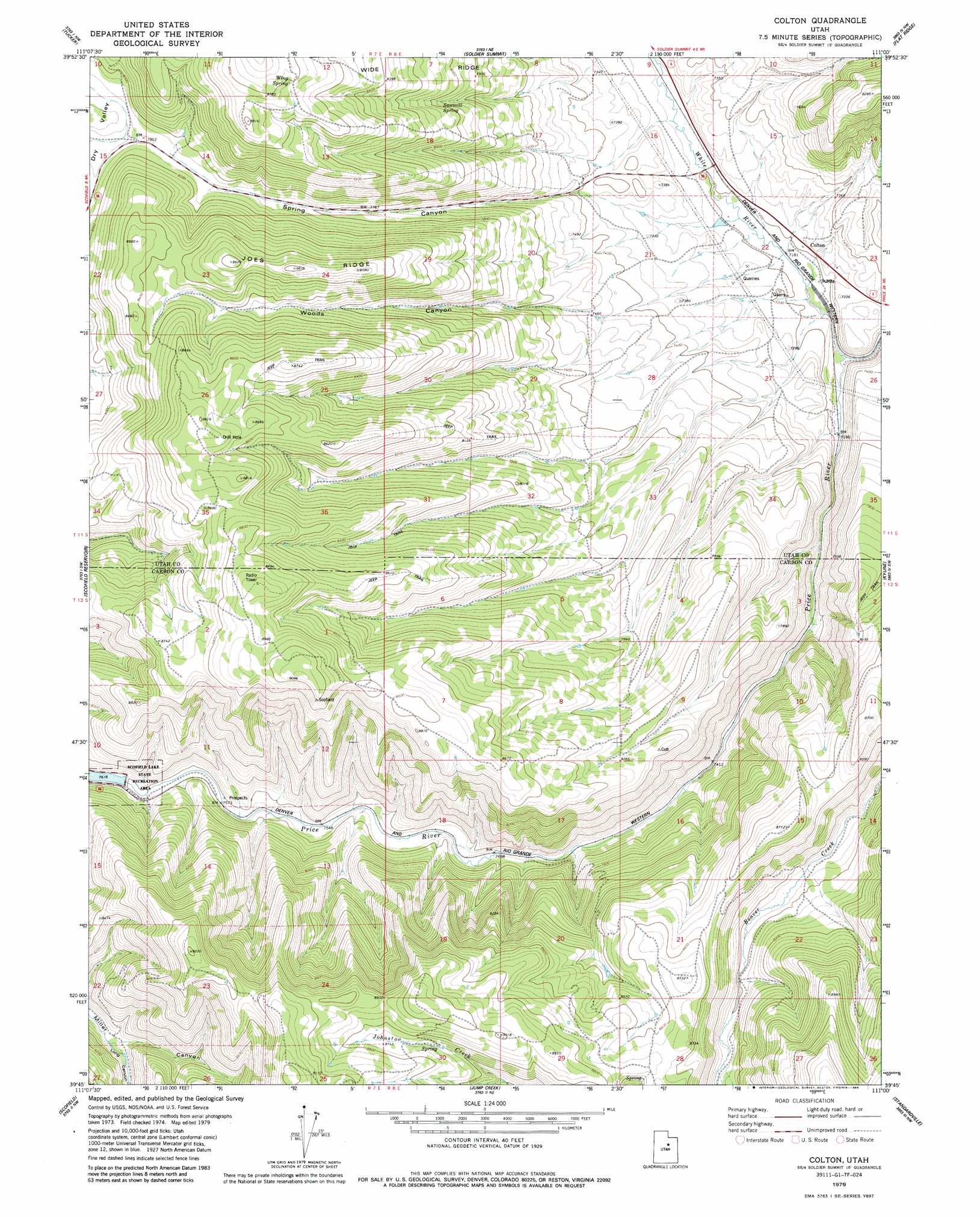
Colton Topo Map Utah
To zoom in, hover over the map of Colton
USGS Topo Quad 39111g1 - 1:24,000 scale
| Topo Map Name: | Colton |
| USGS Topo Quad ID: | 39111g1 |
| Print Size: | ca. 21 1/4" wide x 27" high |
| Southeast Coordinates: | 39.75° N latitude / 111° W longitude |
| Map Center Coordinates: | 39.8125° N latitude / 111.0625° W longitude |
| U.S. State: | UT |
| Filename: | o39111g1.jpg |
| Download Map JPG Image: | Colton topo map 1:24,000 scale |
| Map Type: | Topographic |
| Topo Series: | 7.5´ |
| Map Scale: | 1:24,000 |
| Source of Map Images: | United States Geological Survey (USGS) |
| Alternate Map Versions: |
Colton UT 1979, updated 1979 Download PDF Buy paper map Colton UT 1979, updated 1985 Download PDF Buy paper map Colton UT 2011 Download PDF Buy paper map Colton UT 2014 Download PDF Buy paper map |
1:24,000 Topo Quads surrounding Colton
Rays Valley |
Strawberry Reservoir Sw |
Strawberry Reservoir Se |
Strawberry Peak |
Avintaquin Canyon |
Mill Fork |
Tucker |
Soldier Summit |
Flat Ridge |
Gray Head Peak |
C Canyon |
Scofield Reservoir |
Colton |
Kyune |
Matts Summit |
Fairview Lakes |
Scofield |
Jump Creek |
Standardville |
Helper |
Huntington Reservoir |
Candland Mountain |
Wattis |
Pinnacle Peak |
Price |
> Back to 39111e1 at 1:100,000 scale
> Back to 39110a1 at 1:250,000 scale
> Back to U.S. Topo Maps home
Colton topo map: Gazetteer
Colton: Dams
Scofield Dam elevation 2323m 7621′Colton: Populated Places
Colton elevation 2206m 7237′Colton: Reservoirs
Scofield Reservoir elevation 2320m 7611′Colton: Ridges
Joes Ridge elevation 2615m 8579′Colton: Springs
Sawmill Spring elevation 2414m 7919′Wing Spring elevation 2682m 8799′
Colton: Streams
White River elevation 2183m 7162′Colton: Valleys
Dry Valley elevation 2414m 7919′Long Canyon elevation 2398m 7867′
Spring Canyon elevation 2196m 7204′
Woods Canyon elevation 2194m 7198′
Colton digital topo map on disk
Buy this Colton topo map showing relief, roads, GPS coordinates and other geographical features, as a high-resolution digital map file on DVD: