Sutter Topo Map California
To zoom in, hover over the map of Sutter
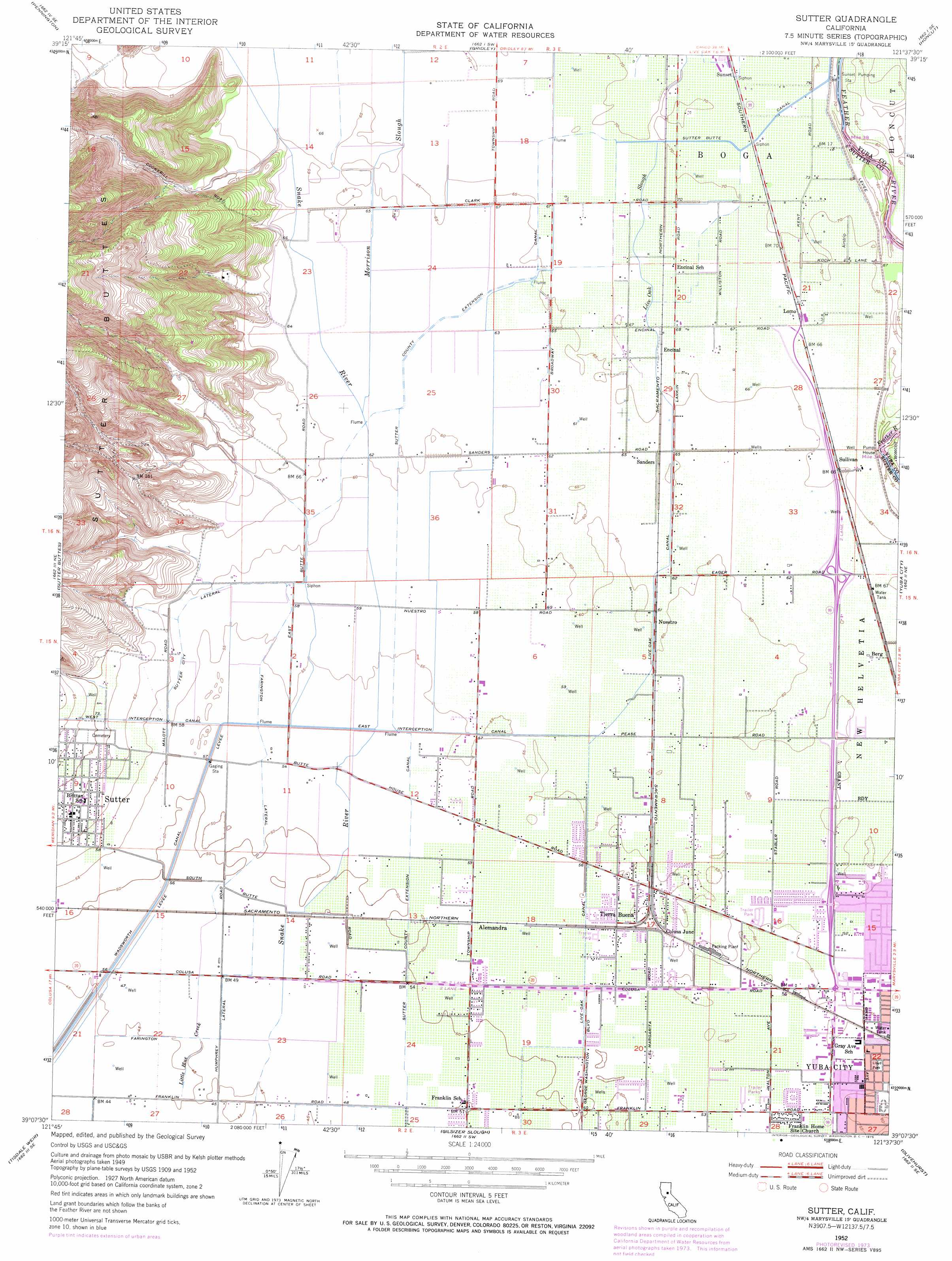
USGS Topo Quad 39121b6 - 1:24,000 scale
| Topo Map Name: | Sutter |
| USGS Topo Quad ID: | 39121b6 |
| Print Size: | ca. 21 1/4" wide x 27" high |
| Southeast Coordinates: | 39.125° N latitude / 121.625° W longitude |
| Map Center Coordinates: | 39.1875° N latitude / 121.6875° W longitude |
| U.S. State: | CA |
| Filename: | o39121b6.jpg |
| Download Map JPG Image: | Sutter topo map 1:24,000 scale |
| Map Type: | Topographic |
| Topo Series: | 7.5´ |
| Map Scale: | 1:24,000 |
| Source of Map Images: | United States Geological Survey (USGS) |
| Alternate Map Versions: |
Sutter CA 1952, updated 1955 Download PDF Buy paper map Sutter CA 1952, updated 1967 Download PDF Buy paper map Sutter CA 1952, updated 1975 Download PDF Buy paper map Sutter CA 1952, updated 1975 Download PDF Buy paper map Sutter CA 2012 Download PDF Buy paper map Sutter CA 2015 Download PDF Buy paper map |
1:24,000 Topo Quads surrounding Sutter
Butte City |
West Of Biggs |
Biggs |
Palermo |
Bangor |
Sanborn Slough |
Pennington |
Gridley |
Honcut |
Loma Rica |
Meridian |
Sutter Buttes |
Sutter |
Yuba City |
Browns Valley |
Grimes |
Tisdale Weir |
Gilsizer Slough |
Olivehurst |
Wheatland |
Dunnigan |
Kirkville |
Sutter Causeway |
Nicolaus |
Sheridan |
> Back to 39121a1 at 1:100,000 scale
> Back to 39120a1 at 1:250,000 scale
> Back to U.S. Topo Maps home
Sutter topo map: Gazetteer
Sutter: Airports
Lomo Airport elevation 22m 72′Sutter: Canals
East Interception Canal elevation 17m 55′Farington Lateral elevation 16m 52′
Humphrey Lateral elevation 15m 49′
Live Oak Canal elevation 19m 62′
Sutter City Lateral elevation 18m 59′
Sutter County Extension Canal elevation 17m 55′
Wadsworth Canal elevation 14m 45′
West Interception Canal elevation 21m 68′
Sutter: Parks
Greenwood Park elevation 18m 59′Kingwood Park elevation 18m 59′
Lloyd Park elevation 17m 55′
Sam Brannan Park elevation 18m 59′
Sutter: Populated Places
Alemandra elevation 17m 55′Berg elevation 20m 65′
Butte House (historical) elevation 18m 59′
Colusa Junction elevation 17m 55′
Encinal elevation 21m 68′
Lomo elevation 21m 68′
Mendoza (historical) elevation 22m 72′
Nuestro elevation 19m 62′
Pease (historical) elevation 18m 59′
Sanders elevation 21m 68′
Stafford (historical) elevation 22m 72′
Sullivan elevation 20m 65′
Tierra Buena elevation 18m 59′
Sutter: Post Offices
Sutter Post Office elevation 22m 72′Sutter: Streams
Live Oak Slough elevation 21m 68′Morrison Slough elevation 19m 62′
Sutter: Valleys
Kinch Canyon elevation 25m 82′Sutter digital topo map on disk
Buy this Sutter topo map showing relief, roads, GPS coordinates and other geographical features, as a high-resolution digital map file on DVD: