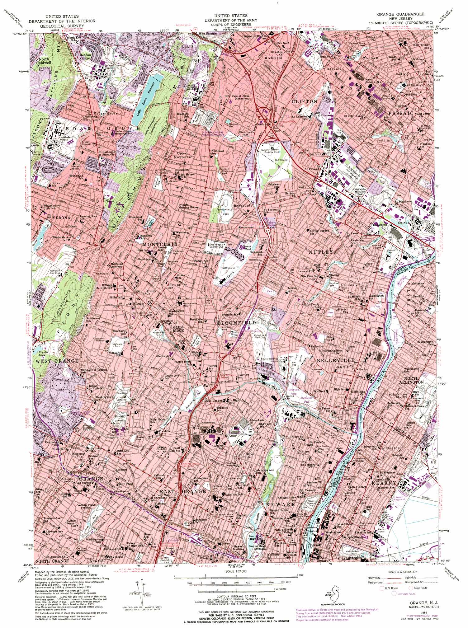
Orange Topo Map New Jersey
To zoom in, hover over the map of Orange
USGS Topo Quad 40074g2 - 1:24,000 scale
| Topo Map Name: | Orange |
| USGS Topo Quad ID: | 40074g2 |
| Print Size: | ca. 21 1/4" wide x 27" high |
| Southeast Coordinates: | 40.75° N latitude / 74.125° W longitude |
| Map Center Coordinates: | 40.8125° N latitude / 74.1875° W longitude |
| U.S. State: | NJ |
| Filename: | o40074g2.jpg |
| Download Map JPG Image: | Orange topo map 1:24,000 scale |
| Map Type: | Topographic |
| Topo Series: | 7.5´ |
| Map Scale: | 1:24,000 |
| Source of Map Images: | United States Geological Survey (USGS) |
| Alternate Map Versions: |
Orange NJ 1947 Download PDF Buy paper map Orange NJ 1955, updated 1958 Download PDF Buy paper map Orange NJ 1955, updated 1965 Download PDF Buy paper map Orange NJ 1955, updated 1972 Download PDF Buy paper map Orange NJ 1955, updated 1982 Download PDF Buy paper map Orange NJ 1995, updated 2000 Download PDF Buy paper map Orange NJ 2011 Download PDF Buy paper map Orange NJ 2014 Download PDF Buy paper map Orange NJ 2016 Download PDF Buy paper map |
1:24,000 Topo Quads surrounding Orange
Newfoundland |
Wanaque |
Ramsey |
Park Ridge |
Nyack |
Boonton |
Pompton Plains |
Paterson |
Hackensack |
Yonkers |
Morristown |
Caldwell |
Orange |
Weehawken |
Central Park |
Chatham |
Roselle |
Elizabeth |
Jersey City |
Brooklyn |
Plainfield |
Perth Amboy |
Arthur Kill |
The Narrows |
Coney Island |
> Back to 40074e1 at 1:100,000 scale
> Back to 40074a1 at 1:250,000 scale
> Back to U.S. Topo Maps home
Orange topo map: Gazetteer
Orange: Airports
Caldwell-Wright Airport (historical) elevation 75m 246′Elmwood Park Heliport elevation 48m 157′
Hoffmann-La Roche Incorporated Heliport elevation 43m 141′
Martens Stadium Heliport elevation 48m 157′
Oval Park Heliport elevation 43m 141′
Soverel Park Heliport elevation 45m 147′
State Police Bloomfield Heliport elevation 54m 177′
Suburban Helistop elevation 36m 118′
Orange: Channels
Arlington Reach elevation 0m 0′Belleville Reach elevation 0m 0′
Kearny Reach elevation 0m 0′
Nutley Reach elevation 0m 0′
Orange: Crossings
Interchange 10 elevation 57m 187′Interchange 11 elevation 58m 190′
Interchange 12 elevation 49m 160′
Interchange 13 elevation 38m 124′
Interchange 145 elevation 52m 170′
Interchange 147 elevation 43m 141′
Interchange 148 elevation 43m 141′
Interchange 148A elevation 36m 118′
Interchange 149 elevation 36m 118′
Interchange 150 elevation 36m 118′
Interchange 151 elevation 54m 177′
Interchange 153 elevation 61m 200′
Interchange 9 elevation 69m 226′
Orange: Dams
Verona Lake Dam elevation 109m 357′Orange: Lakes
Clarks Pond elevation 48m 157′Crystal Lake elevation 183m 600′
Kingsland Lake elevation 9m 29′
Orange: Parks
Alonzo F Bonsal Wildlife Preserve elevation 64m 209′Alumni Green elevation 130m 426′
Anderson Park elevation 102m 334′
Ashland Stadium elevation 46m 150′
Belleville Park elevation 38m 124′
Bergen County Park South elevation 3m 9′
Booth Park elevation 26m 85′
Branch Brook Park elevation 31m 101′
Branch Brook Skating Rink elevation 30m 98′
Brookdale County Park elevation 61m 200′
Brookdale Park elevation 58m 190′
Brookside Park elevation 40m 131′
Cedar Grove Community Park elevation 73m 239′
Columbian Playground elevation 42m 137′
Davella Mills County Park elevation 143m 469′
Demuro Park elevation 45m 147′
Eagle Rock Reservation elevation 177m 580′
Edgemont Memorial Park elevation 96m 314′
Edison National Historic Site elevation 78m 255′
Elmwood Park elevation 49m 160′
Essex Avenue Park elevation 85m 278′
Everett Park elevation 145m 475′
Father Glotzbach Park elevation 6m 19′
Flora Louden Park elevation 41m 134′
Foley Field elevation 34m 111′
Glenfield Park elevation 64m 209′
Hendricks Field elevation 36m 118′
Kearny Playground elevation 5m 16′
Kingsland Park elevation 7m 22′
Memorial Park elevation 17m 55′
Mills Reservation County Park elevation 153m 501′
Monsignor Owens Park elevation 10m 32′
Mountainside Park elevation 127m 416′
Nichols Park elevation 27m 88′
Nishuane Park elevation 83m 272′
Orange Oval elevation 49m 160′
Orange Park elevation 61m 200′
Passaic River Park elevation 3m 9′
Pearl Brook Park elevation 60m 196′
Porter Park elevation 91m 298′
Pulaski Park elevation 47m 154′
Rand Park elevation 85m 278′
Riverbank Park elevation 19m 62′
Soverel Park elevation 42m 137′
Sprague Field elevation 114m 374′
Tuers Park elevation 73m 239′
Vassar Field elevation 59m 193′
Verona Park elevation 112m 367′
Veterans Memorial Park elevation 20m 65′
Watsessing Park elevation 36m 118′
Weasel Brook Park elevation 24m 78′
West Hudson Park elevation 15m 49′
Woodman Field elevation 90m 295′
Yantacaw Brook Park elevation 64m 209′
Yantacaw Park elevation 32m 104′
Yogi Berra Stadium elevation 118m 387′
Orange: Populated Places
Allwood elevation 43m 141′Ampere elevation 37m 121′
Arlington elevation 36m 118′
Athenia elevation 36m 118′
Avondale elevation 35m 114′
Belleville elevation 16m 52′
Bloomfield elevation 45m 147′
Brookdale elevation 53m 173′
Cedar Grove elevation 91m 298′
Clifton elevation 57m 187′
Delawanna elevation 11m 36′
East Orange elevation 48m 157′
Elm Park Village elevation 54m 177′
Glen Ridge elevation 66m 216′
Great Notch elevation 95m 311′
Kearny elevation 32m 104′
Little Falls elevation 110m 360′
Llewellyn Park elevation 98m 321′
Meadow Village elevation 96m 314′
Montclair elevation 93m 305′
Montclair Heights elevation 109m 357′
North Arlington elevation 42m 137′
Nutley elevation 43m 141′
Orange elevation 59m 193′
Passaic elevation 34m 111′
Richfield elevation 60m 196′
Roseville elevation 42m 137′
The Village at Little Falls elevation 116m 380′
Upper Montclair elevation 96m 314′
Verona elevation 125m 410′
West Orange elevation 135m 442′
Orange: Post Offices
Belleville Post Office elevation 15m 49′Cedar Grove Post Office elevation 91m 298′
Clifton Post Office elevation 35m 114′
East Orange Main Post Office elevation 49m 160′
Kearney Post Office elevation 40m 131′
Montclair Post Office elevation 82m 269′
Nutley Post Office elevation 22m 72′
Passaic Main Post Office elevation 19m 62′
Orange: Reservoirs
Basking Reservoir elevation 74m 242′Cedar Grove Reservoir elevation 119m 390′
Hendricks Pond elevation 30m 98′
Hughes Lake elevation 17m 55′
Oakes Pond (historical) elevation 29m 95′
Verona Lake elevation 109m 357′
Yantacaw Pond elevation 11m 36′
Orange: Streams
Plog Brook elevation 34m 111′Second River elevation 0m 0′
Third River elevation 0m 0′
Weasel Brook elevation 15m 49′
Orange: Summits
Stony Hill elevation 179m 587′Orange digital topo map on disk
Buy this Orange topo map showing relief, roads, GPS coordinates and other geographical features, as a high-resolution digital map file on DVD:
Atlantic Coast (NY, NJ, PA, DE, MD, VA, NC)
Buy digital topo maps: Atlantic Coast (NY, NJ, PA, DE, MD, VA, NC)
 map DVD")