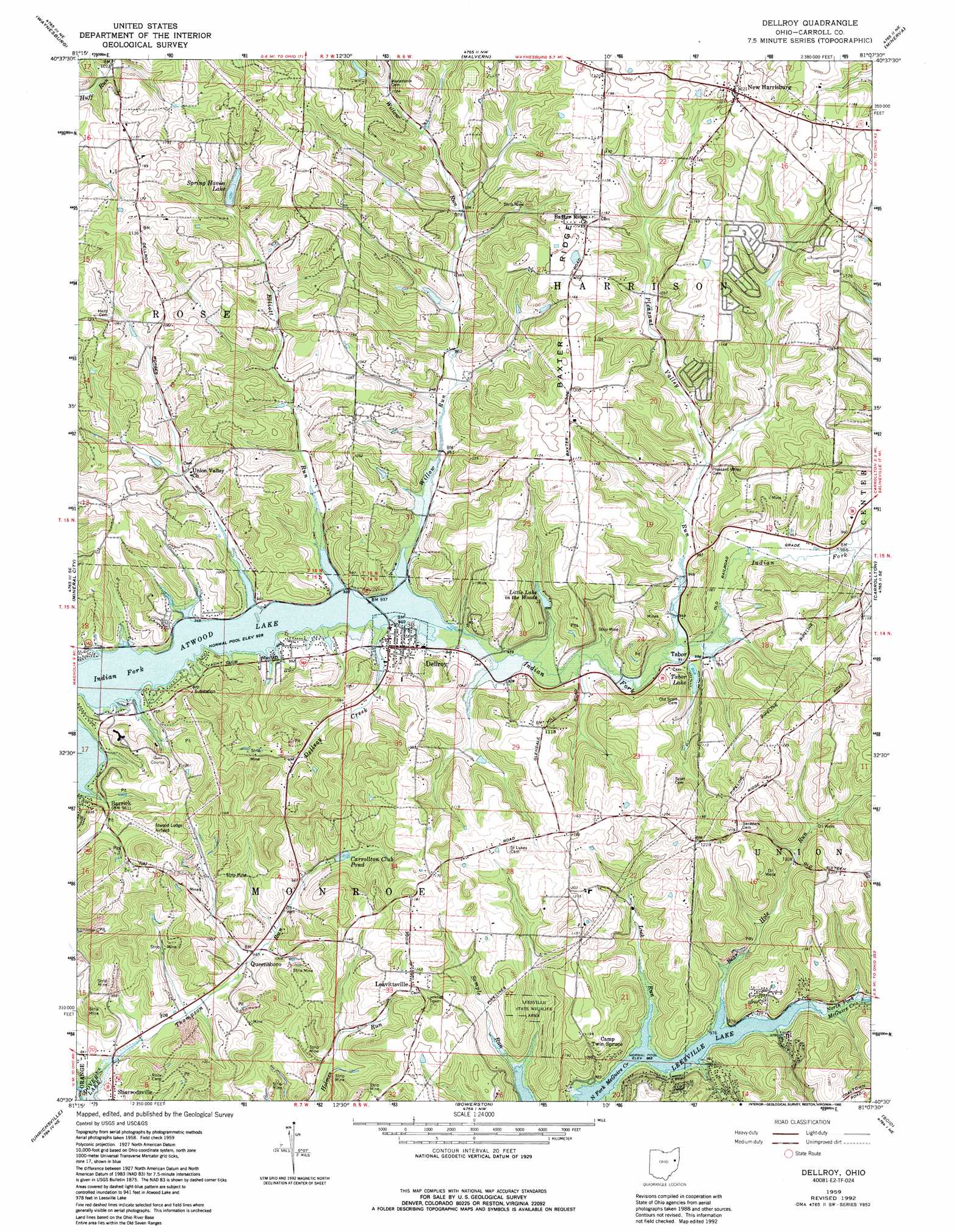
Dellroy Topo Map Ohio
To zoom in, hover over the map of Dellroy
USGS Topo Quad 40081e2 - 1:24,000 scale
| Topo Map Name: | Dellroy |
| USGS Topo Quad ID: | 40081e2 |
| Print Size: | ca. 21 1/4" wide x 27" high |
| Southeast Coordinates: | 40.5° N latitude / 81.125° W longitude |
| Map Center Coordinates: | 40.5625° N latitude / 81.1875° W longitude |
| U.S. State: | OH |
| Filename: | o40081e2.jpg |
| Download Map JPG Image: | Dellroy topo map 1:24,000 scale |
| Map Type: | Topographic |
| Topo Series: | 7.5´ |
| Map Scale: | 1:24,000 |
| Source of Map Images: | United States Geological Survey (USGS) |
| Alternate Map Versions: |
Dellroy OH 1959, updated 1961 Download PDF Buy paper map Dellroy OH 1959, updated 1972 Download PDF Buy paper map Dellroy OH 1959, updated 1978 Download PDF Buy paper map Dellroy OH 1959, updated 1992 Download PDF Buy paper map Dellroy OH 1994, updated 1998 Download PDF Buy paper map Dellroy OH 2010 Download PDF Buy paper map Dellroy OH 2013 Download PDF Buy paper map Dellroy OH 2016 Download PDF Buy paper map |
1:24,000 Topo Quads surrounding Dellroy
Canton West |
Canton East |
Robertsville |
Homeworth |
Hanoverton |
Bolivar |
Waynesburg |
Malvern |
Minerva |
Kensington |
Dover |
Mineral City |
Dellroy |
Carrollton |
Bergholz |
New Philadelphia |
Uhrichsville |
Bowerston |
Scio |
Amsterdam |
Gnadenhutten |
Tippecanoe |
Deersville |
Jewett |
Cadiz |
> Back to 40081e1 at 1:100,000 scale
> Back to 40080a1 at 1:250,000 scale
> Back to U.S. Topo Maps home
Dellroy topo map: Gazetteer
Dellroy: Airports
Atwood Lodge Airport elevation 319m 1046′Atwood Lodge Heliport elevation 330m 1082′
Dellroy: Dams
Little Lake in the Woods Dam elevation 305m 1000′Dellroy: Lakes
Carrollton Club Pond elevation 307m 1007′Spring Haven Lake elevation 320m 1049′
Tabor Lake elevation 295m 967′
Dellroy: Parks
Leesville State Wildlife Area elevation 309m 1013′Dellroy: Populated Places
Arrowhead elevation 287m 941′Atwood (historical) elevation 282m 925′
Atwood Cove elevation 286m 938′
Atwood Crossing elevation 287m 941′
Atwood Pines elevation 287m 941′
Atwood Valley elevation 293m 961′
Atwood Village elevation 293m 961′
Cove Cottage Area elevation 294m 964′
Dellroy elevation 292m 958′
Glenmar elevation 290m 951′
Grampian Hills elevation 348m 1141′
Lakeview elevation 298m 977′
Leavittsville elevation 356m 1167′
New Harrisburg elevation 372m 1220′
Palermo-on-the-Lakes elevation 319m 1046′
Paradise Point elevation 291m 954′
Pine Hill elevation 315m 1033′
Pines Cottage Area elevation 290m 951′
Piney View elevation 331m 1085′
Queensboro elevation 288m 944′
Rockwood Park elevation 304m 997′
Tabor elevation 288m 944′
Valleyview elevation 288m 944′
Dellroy: Post Offices
Atwood Post Office (historical) elevation 282m 925′Dellroy Post Office elevation 293m 961′
Leavittsville Post Office (historical) elevation 354m 1161′
New Harrisburg Post Office (historical) elevation 372m 1220′
Tabor Post Office (historical) elevation 289m 948′
Dellroy: Reservoirs
Little Lake in the Woods elevation 305m 1000′Dellroy: Ridges
Baxter Ridge elevation 366m 1200′Dellroy: Streams
Bear Hole Run elevation 298m 977′Cold Spring Run elevation 290m 951′
Dellroy Creek elevation 286m 938′
Elliott Run elevation 286m 938′
Falling Branch elevation 279m 915′
Lick Run elevation 295m 967′
Pleasant Valley Run elevation 285m 935′
Thompson Run elevation 273m 895′
Willow Run elevation 285m 935′
Dellroy digital topo map on disk
Buy this Dellroy topo map showing relief, roads, GPS coordinates and other geographical features, as a high-resolution digital map file on DVD:
 map DVD")