Ashland South Topo Map Ohio
To zoom in, hover over the map of Ashland South
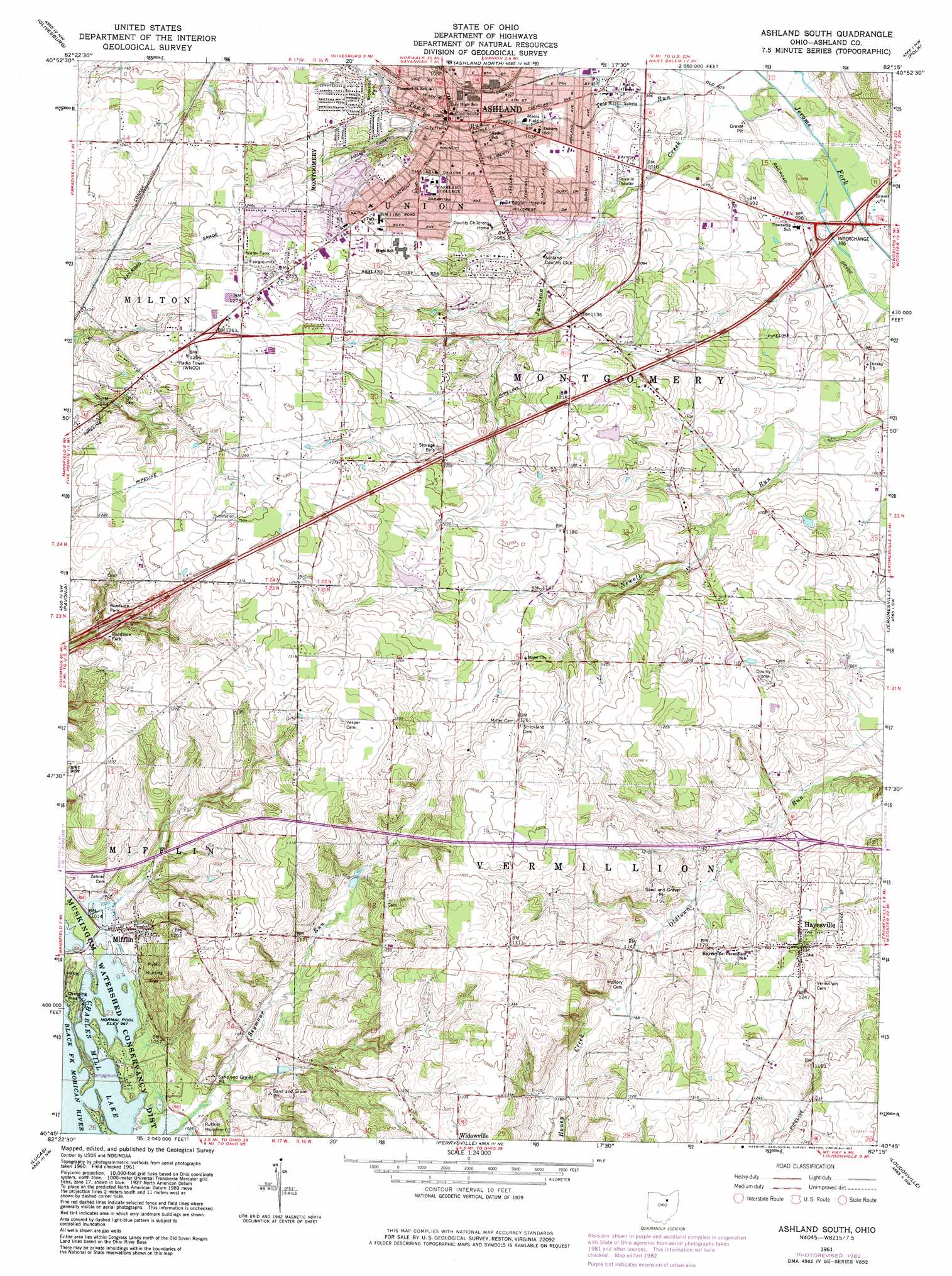
USGS Topo Quad 40082g3 - 1:24,000 scale
| Topo Map Name: | Ashland South |
| USGS Topo Quad ID: | 40082g3 |
| Print Size: | ca. 21 1/4" wide x 27" high |
| Southeast Coordinates: | 40.75° N latitude / 82.25° W longitude |
| Map Center Coordinates: | 40.8125° N latitude / 82.3125° W longitude |
| U.S. State: | OH |
| Filename: | o40082g3.jpg |
| Download Map JPG Image: | Ashland South topo map 1:24,000 scale |
| Map Type: | Topographic |
| Topo Series: | 7.5´ |
| Map Scale: | 1:24,000 |
| Source of Map Images: | United States Geological Survey (USGS) |
| Alternate Map Versions: |
Ashland South OH 1961, updated 1963 Download PDF Buy paper map Ashland South OH 1961, updated 1973 Download PDF Buy paper map Ashland South OH 1961, updated 1983 Download PDF Buy paper map Ashland South OH 2010 Download PDF Buy paper map Ashland South OH 2013 Download PDF Buy paper map Ashland South OH 2016 Download PDF Buy paper map |
1:24,000 Topo Quads surrounding Ashland South
Greenwich |
New London |
Nova |
Sullivan |
Lodi |
Shiloh |
Olivesburg |
Ashland North |
Polk |
West Salem |
Mansfield North |
Pavonia |
Ashland South |
Jeromesville |
New Pittsburg |
Mansfield South |
Lucas |
Perrysville |
Loudonville |
Shreve |
Bellville |
Butler |
Jelloway |
Greer |
Glenmont |
> Back to 40082e1 at 1:100,000 scale
> Back to 40082a1 at 1:250,000 scale
> Back to U.S. Topo Maps home
Ashland South topo map: Gazetteer
Ashland South: Airports
Samaritan Hospital Heliport elevation 341m 1118′Ashland South: Crossings
Interchange 186 elevation 300m 984′Ashland South: Dams
Jacobs Lake Dam elevation 358m 1174′Ashland South: Parks
Brookside Park elevation 345m 1131′Cahn Grove Park elevation 309m 1013′
Center Street Historic District elevation 340m 1115′
Charles Mill Lake Park elevation 315m 1033′
Davis Road Park elevation 301m 987′
Donges Field elevation 354m 1161′
Myers Field elevation 314m 1030′
Ruffner Monument elevation 317m 1040′
Sarver Field elevation 356m 1167′
Ashland South: Populated Places
Ashland elevation 325m 1066′Carpenters Mobile Home Park elevation 308m 1010′
Hayesville elevation 378m 1240′
Hopes Mobile Home Park elevation 309m 1013′
Mifflin elevation 326m 1069′
Mifflin Cottage Area elevation 308m 1010′
South Peninsula Cottage Area elevation 308m 1010′
Trailerville Mobile Home Park elevation 308m 1010′
Westview Mobile Home Park elevation 379m 1243′
Ashland South: Post Offices
Ashland Post Office elevation 326m 1069′Hayesville Post Office elevation 378m 1240′
Mifflin Post Office (historical) elevation 327m 1072′
Ashland South: Reservoirs
Jacobs Lake elevation 358m 1174′Ashland South: Streams
Jamison Creek elevation 299m 980′Ruffner Run elevation 304m 997′
Ashland South digital topo map on disk
Buy this Ashland South topo map showing relief, roads, GPS coordinates and other geographical features, as a high-resolution digital map file on DVD:
 map DVD")