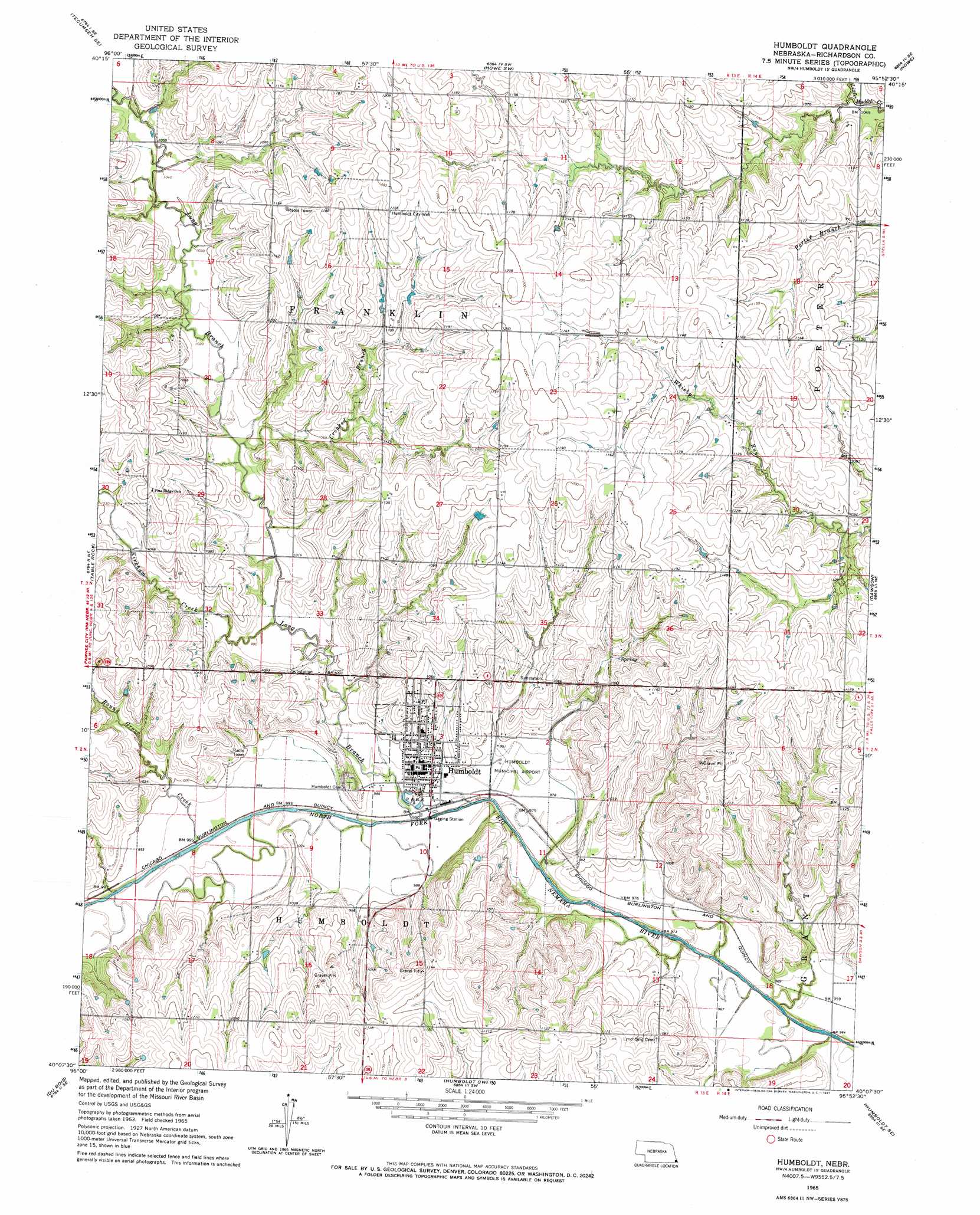
Humboldt Topo Map Nebraska
To zoom in, hover over the map of Humboldt
USGS Topo Quad 40095b8 - 1:24,000 scale
| Topo Map Name: | Humboldt |
| USGS Topo Quad ID: | 40095b8 |
| Print Size: | ca. 21 1/4" wide x 27" high |
| Southeast Coordinates: | 40.125° N latitude / 95.875° W longitude |
| Map Center Coordinates: | 40.1875° N latitude / 95.9375° W longitude |
| U.S. State: | NE |
| Filename: | O40095B8.jpg |
| Download Map JPG Image: | Humboldt topo map 1:24,000 scale |
| Map Type: | Topographic |
| Topo Series: | 7.5´ |
| Map Scale: | 1:24,000 |
| Source of Map Images: | United States Geological Survey (USGS) |
| Alternate Map Versions: |
Humboldt NE 1965, updated 1967 Download PDF Buy paper map Humboldt NE 2011 Download PDF Buy paper map Humboldt NE 2014 Download PDF Buy paper map |
1:24,000 Topo Quads surrounding Humboldt
Tecumseh Nw |
Tecumseh Ne |
Brock |
Auburn |
Peru |
Tecumseh |
Tecumseh Se |
Howe Sw |
Howe |
Nemaha |
Steinauer |
Table Rock |
Humboldt |
Dawson |
Verdon |
Pawnee City |
Du Bois |
Humboldt Sw |
Humboldt Se |
Salem |
Seneca Nw |
Saint Benedict |
Bern |
Sabetha |
Morrill |
> Back to 40095a1 at 1:100,000 scale
> Back to 40094a1 at 1:250,000 scale
> Back to U.S. Topo Maps home
Humboldt topo map: Gazetteer
Humboldt: Airports
Humboldt Hospital Heliport elevation 304m 997′Humboldt: Dams
Yearling Dam elevation 344m 1128′Humboldt: Parks
Humboldt Lake Park elevation 301m 987′Kirkmans Cove Recreation Area elevation 317m 1040′
Lions Club Fountain elevation 312m 1023′
Town Square Park elevation 310m 1017′
Humboldt: Populated Places
Humboldt elevation 312m 1023′Humboldt: Post Offices
Humboldt Post Office elevation 312m 1023′Long Branch Post Office (historical) elevation 327m 1072′
Monond Post Office (historical) elevation 298m 977′
Humboldt: Reservoirs
Kirkmans Cove Lake elevation 317m 1040′Yearling Reservoir elevation 344m 1128′
Humboldt: Streams
Crooked Branch elevation 307m 1007′Kirkham Creek elevation 305m 1000′
Long Branch elevation 291m 954′
Round Grove Creek elevation 299m 980′
Humboldt: Wells
Humboldt City Well elevation 364m 1194′Humboldt digital topo map on disk
Buy this Humboldt topo map showing relief, roads, GPS coordinates and other geographical features, as a high-resolution digital map file on DVD: