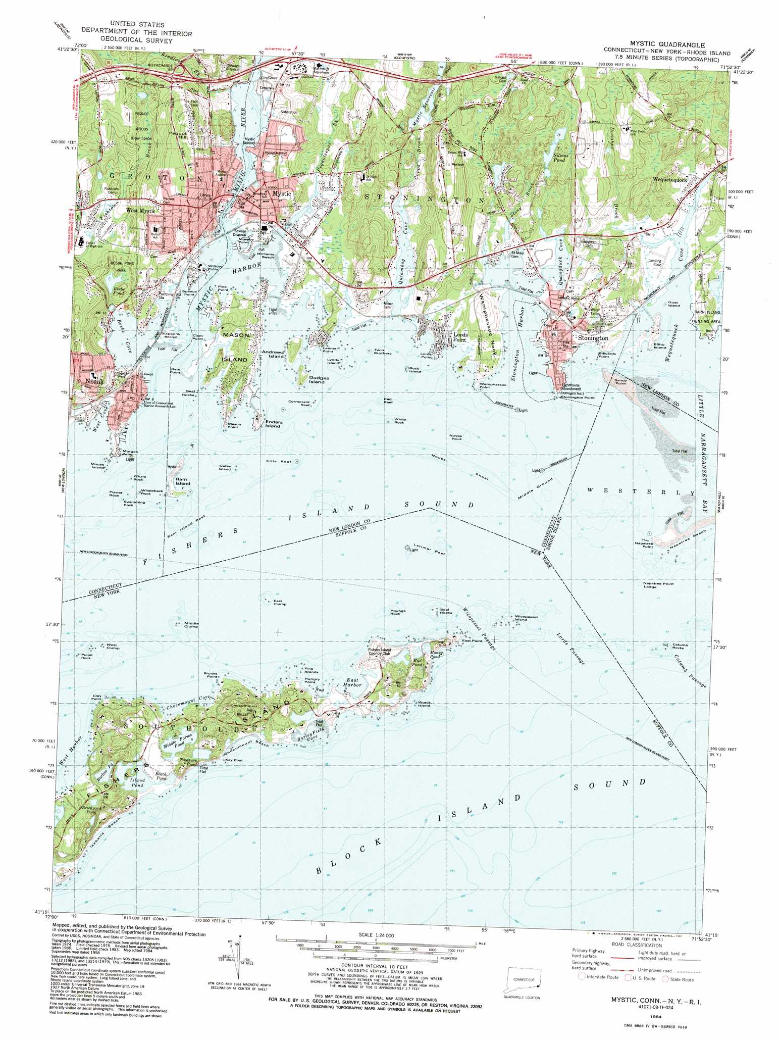
Mystic Topo Map Connecticut
To zoom in, hover over the map of Mystic
USGS Topo Quad 41071c8 - 1:24,000 scale
| Topo Map Name: | Mystic |
| USGS Topo Quad ID: | 41071c8 |
| Print Size: | ca. 21 1/4" wide x 27" high |
| Southeast Coordinates: | 41.25° N latitude / 71.875° W longitude |
| Map Center Coordinates: | 41.3125° N latitude / 71.9375° W longitude |
| U.S. States: | CT, NY, RI |
| Filename: | o41071c8.jpg |
| Download Map JPG Image: | Mystic topo map 1:24,000 scale |
| Map Type: | Topographic |
| Topo Series: | 7.5´ |
| Map Scale: | 1:24,000 |
| Source of Map Images: | United States Geological Survey (USGS) |
| Alternate Map Versions: |
Mystic CT 1958, updated 1959 Download PDF Buy paper map Mystic CT 1958, updated 1968 Download PDF Buy paper map Mystic CT 1958, updated 1970 Download PDF Buy paper map Mystic CT 1984, updated 1984 Download PDF Buy paper map Mystic CT 1984, updated 1987 Download PDF Buy paper map Mystic CT 2011 Download PDF Buy paper map Mystic CT 2012 Download PDF Buy paper map Mystic CT 2015 Download PDF Buy paper map |
1:24,000 Topo Quads surrounding Mystic
Fitchville |
Norwich |
Jewett City |
Voluntown |
Hope Valley |
Montville |
Uncasville |
Old Mystic |
Ashaway |
Carolina |
Niantic |
New London |
Mystic |
Watch Hill |
Quonochontaug |
Plum Island |
||||
Gardiners Island West |
Gardiners Island East |
Montauk Point |
> Back to 41071a1 at 1:100,000 scale
> Back to 41070a1 at 1:250,000 scale
> Back to U.S. Topo Maps home
Mystic topo map: Gazetteer
Mystic: Airports
Stonington Airpark elevation 1m 3′Stonington Landing Field elevation 0m 0′
Mystic: Bars
Catumb Rocks elevation 0m 0′Cormorant Reef elevation 0m 0′
East Clump elevation 0m 0′
Eel Grass Ground elevation 0m 0′
Ellis Reef elevation 0m 0′
Latimer Reef elevation 0m 0′
Middle Clump elevation 0m 0′
Noyes Shoal elevation 0m 0′
Pulpit Rock elevation 0m 0′
Ram Island Shoal elevation 0m 0′
Red Reef elevation 0m 0′
Seal Rocks elevation 0m 0′
West Clump elevation 0m 0′
Mystic: Bays
Barleyfield Cove elevation 0m 0′Beebe Cove elevation 0m 0′
Chocomount Cove elevation 0m 0′
Collins Cove elevation 0m 0′
East Harbor elevation 0m 0′
Fishers Island Sound elevation 0m 0′
Fishers Island Sound elevation 0m 0′
Ice Harbor elevation 0m 0′
Lamberts Cove elevation 0m 0′
Lobster Cove elevation 2m 6′
Mine Cove elevation 0m 0′
Mud Cove elevation 0m 0′
Mystic Harbor elevation 0m 0′
Peggy Bay elevation 0m 0′
Quanaduck Cove elevation 0m 0′
Quiambog Cove elevation 0m 0′
Stonington Harbor elevation 0m 0′
Wequetequock Cove elevation 0m 0′
West Cove elevation 0m 0′
Mystic: Beaches
Chocomount Beach elevation 0m 0′DuBois Beach elevation 0m 0′
Esker Point Beach elevation 0m 0′
Isabella Beach elevation 0m 0′
Nauyaug Coast elevation 0m 0′
South Beach elevation 0m 0′
Mystic: Benches
Napatree Point Ledge elevation 0m 0′Mystic: Bridges
Mystic Bascule Bridge elevation 0m 0′The Riding Way elevation 1m 3′
Mystic: Capes
Abigail Point elevation 0m 0′Brooks Point elevation 7m 22′
Clam Point elevation 0m 0′
Clay Point elevation 11m 36′
East Point elevation 6m 19′
Esker Point elevation 0m 0′
Hungry Point elevation 11m 36′
Lords Point elevation 0m 0′
Mason Neck elevation 0m 0′
Mason Point elevation 3m 9′
Mistack elevation 7m 22′
Money Point elevation 0m 0′
Morgan Point elevation 0m 0′
Mud Point elevation 2m 6′
Murphy Point elevation 1m 3′
Napatree Point elevation 10m 32′
Palmer Neck elevation 3m 9′
Pine Point elevation 0m 0′
Ram Point elevation 1m 3′
Randall Point elevation 0m 0′
Sandy Point elevation 4m 13′
Shipyard Point elevation 0m 0′
Spence Point elevation 0m 0′
Stonington Point elevation 3m 9′
The Point elevation 0m 0′
Wamphassuc Neck elevation 12m 39′
Wamphassuc Point elevation 5m 16′
Willow Point elevation 0m 0′
Mystic: Channels
Bass Strait elevation 0m 0′Catumb Passage elevation 0m 0′
Lords Passage elevation 0m 0′
Lords Passage elevation 0m 0′
Wicopesset Passage elevation 0m 0′
Mystic: Crossings
Interchange 89 elevation 30m 98′Mystic: Dams
Deans Reservoir Dam elevation 22m 72′East Breakwater elevation 0m 0′
Old Breakwater elevation 3m 9′
Silvias Pond Dam elevation 23m 75′
Stonington Breakwater elevation 0m 0′
Mystic: Islands
Andrews Island elevation 10m 32′Dodges Island elevation 7m 22′
Elihu Island elevation 7m 22′
Enders Island elevation 8m 26′
Fishers Island elevation 0m 0′
Gatanby Rock elevation 0m 0′
Gates Island elevation 0m 0′
Goat Island elevation 0m 0′
Lyddy Island elevation 1m 3′
Mason Island elevation 10m 32′
Mouse Island elevation 0m 0′
Noyes Rock elevation 0m 0′
Planet Rock elevation 0m 0′
Ram Island elevation 7m 22′
Rock Island elevation 0m 0′
Sandy Point elevation 0m 0′
Seal Rocks elevation 0m 0′
Sixpenny Island elevation 1m 3′
Swimming Rock elevation 0m 0′
Twin Brothers elevation 0m 0′
Whale Rock elevation 0m 0′
Whaleback Rock elevation 0m 0′
White Rock elevation 0m 0′
Wicopesset Island elevation 1m 3′
Wreck Island elevation 0m 0′
Mystic: Lakes
Barlow Pond elevation 0m 0′Beach Pond elevation 0m 0′
Beebe Pond elevation 11m 36′
Brickyard Pond elevation 0m 0′
Ice Pond elevation 5m 16′
Island Pond elevation 0m 0′
Middle Farms Pond elevation 2m 6′
Money Pond elevation 0m 0′
Mud Pond elevation 0m 0′
Treasure Pond elevation 0m 0′
Mystic: Parks
Barn Island Wildlife Management Area elevation 8m 26′Bel-Aire Park elevation 10m 32′
Cannon Square elevation 0m 0′
Denison Homestead elevation 21m 68′
Marinelife Aquarium elevation 8m 26′
Mason Monument elevation 65m 213′
Mystic Bridge Historic District elevation 3m 9′
Mystic Ridge Subdivision Park elevation 53m 173′
Peace Nature Sanctuary elevation 33m 108′
Pequot Woods Public Area elevation 26m 85′
Ramblewood Park elevation 20m 65′
Spicer Park elevation 12m 39′
Stony Hill Subdivision Park elevation 32m 104′
Williams Beach Park elevation 0m 0′
Woodcrest Park elevation 36m 118′
Mystic: Populated Places
Lords Point elevation 4m 13′Mystic elevation 3m 9′
Mystic Seaport elevation 0m 0′
Noank elevation 10m 32′
Stonington elevation 9m 29′
Wequetequock elevation 0m 0′
West Mystic elevation 47m 154′
Mystic: Post Offices
Mystic Post Office elevation 3m 9′Noank Station Groton Post Office elevation 18m 59′
Stonington Post Office (historical) elevation 7m 22′
West Mystic Post Office elevation 5m 16′
Mystic: Reservoirs
Deans Reservoir elevation 22m 72′Mystic Reservoir elevation 14m 45′
Silvias Pond elevation 23m 75′
Mystic: Streams
Bindloss Brook elevation 0m 0′Copps Brook elevation 0m 0′
Donahue Brook elevation 0m 0′
Eccleston Brook elevation 7m 22′
Mystic River elevation 0m 0′
Pequotsepos Brook elevation 0m 0′
Stony Brook elevation 0m 0′
Wequetequock River elevation 0m 0′
Mystic: Summits
Chocomount elevation 43m 141′Pequot Hill elevation 63m 206′
Pine Hill elevation 6m 19′
Mystic digital topo map on disk
Buy this Mystic topo map showing relief, roads, GPS coordinates and other geographical features, as a high-resolution digital map file on DVD:
Maine, New Hampshire, Rhode Island & Eastern Massachusetts
Buy digital topo maps: Maine, New Hampshire, Rhode Island & Eastern Massachusetts